Oz, Isère
| Oz | |
|---|---|
| Commune | |
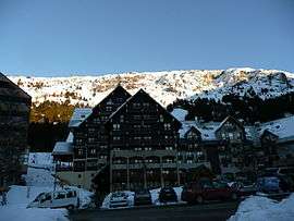 The ski station of Oz | |
 Oz Location within Auvergne-Rhône-Alpes region  Oz | |
| Coordinates: 45°08′26″N 6°03′04″E / 45.1406°N 6.0511°ECoordinates: 45°08′26″N 6°03′04″E / 45.1406°N 6.0511°E | |
| Country | France |
| Region | Auvergne-Rhône-Alpes |
| Department | Isère |
| Arrondissement | Grenoble |
| Canton | Oisans-Romanche |
| Government | |
| • Mayor (2014–2020) | André Genevois |
| Area1 | 16.8 km2 (6.5 sq mi) |
| Population (2011)2 | 228 |
| • Density | 14/km2 (35/sq mi) |
| Time zone | UTC+1 (CET) |
| • Summer (DST) | UTC+2 (CEST) |
| INSEE/Postal code | 38289 /38114 |
| Elevation |
716–3,320 m (2,349–10,892 ft) (avg. 810 m or 2,660 ft) |
|
1 French Land Register data, which excludes lakes, ponds, glaciers > 1 km2 (0.386 sq mi or 247 acres) and river estuaries. 2 Population without double counting: residents of multiple communes (e.g., students and military personnel) only counted once. | |
Oz is a commune in the Isère department in southeastern France.
Population
| Historical population | ||
|---|---|---|
| Year | Pop. | ±% |
| 1793 | 888 | — |
| 1806 | 895 | +0.8% |
| 1821 | 965 | +7.8% |
| 1831 | 1,026 | +6.3% |
| 1841 | 1,094 | +6.6% |
| 1851 | 982 | −10.2% |
| 1861 | 852 | −13.2% |
| 1872 | 809 | −5.0% |
| 1881 | 810 | +0.1% |
| 1891 | 636 | −21.5% |
| 1901 | 652 | +2.5% |
| 1911 | 676 | +3.7% |
| 1921 | 572 | −15.4% |
| 1931 | 466 | −18.5% |
| 1946 | 368 | −21.0% |
| 1954 | 260 | −29.3% |
| 1962 | 213 | −18.1% |
| 1968 | 139 | −34.7% |
| 1975 | 105 | −24.5% |
| 1982 | 127 | +21.0% |
| 1990 | 136 | +7.1% |
| 1999 | 153 | +12.5% |
| 2006 | 197 | +28.8% |
| 2011 | 228 | +15.7% |
See also
References
| Wikimedia Commons has media related to Oz (Isère). |
This article is issued from
Wikipedia.
The text is licensed under Creative Commons - Attribution - Sharealike.
Additional terms may apply for the media files.