Meyrieu-les-Étangs
| Meyrieu-les-Étangs | |
|---|---|
| Commune | |
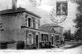 The town hall and schools in 1913 | |
 Meyrieu-les-Étangs Location within Auvergne-Rhône-Alpes region  Meyrieu-les-Étangs | |
| Coordinates: 45°30′51″N 5°12′02″E / 45.5142°N 5.2006°ECoordinates: 45°30′51″N 5°12′02″E / 45.5142°N 5.2006°E | |
| Country | France |
| Region | Auvergne-Rhône-Alpes |
| Department | Isère |
| Arrondissement | Vienne |
| Canton | L'Isle-d'Abeau |
| Intercommunality | Saint-Jeannaise |
| Government | |
| • Mayor (2014–2020) | Alain Couturier |
| Area1 | 8.54 km2 (3.30 sq mi) |
| Population (2011)2 | 878 |
| • Density | 100/km2 (270/sq mi) |
| Time zone | UTC+1 (CET) |
| • Summer (DST) | UTC+2 (CEST) |
| INSEE/Postal code | 38231 /38440 |
| Elevation |
410–527 m (1,345–1,729 ft) (avg. 390 m or 1,280 ft) |
|
1 French Land Register data, which excludes lakes, ponds, glaciers > 1 km2 (0.386 sq mi or 247 acres) and river estuaries. 2 Population without double counting: residents of multiple communes (e.g., students and military personnel) only counted once. | |
Meyrieu-les-Étangs is a commune in the Isère department in southeastern France.
Populagion
| Historical population | ||
|---|---|---|
| Year | Pop. | ±% |
| 1962 | 377 | — |
| 1968 | 423 | +12.2% |
| 1975 | 416 | −1.7% |
| 1982 | 495 | +19.0% |
| 1990 | 551 | +11.3% |
| 1999 | 725 | +31.6% |
| 2006 | 757 | +4.4% |
| 2011 | 878 | +16.0% |
Twin towns
Meyrieu-les-Étangs is twinned with:

See also
References
| Wikimedia Commons has media related to Meyrieu-les-Étangs. |
This article is issued from
Wikipedia.
The text is licensed under Creative Commons - Attribution - Sharealike.
Additional terms may apply for the media files.