Koori, Fukushima
| Koori 桑折町 | |||
|---|---|---|---|
| Town | |||
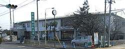 Koori Town Hall | |||
| |||
|
Location of Koori in Fukushima Prefecture | |||
 Koori | |||
| Coordinates: 37°50′58″N 140°30′59″E / 37.84944°N 140.51639°ECoordinates: 37°50′58″N 140°30′59″E / 37.84944°N 140.51639°E | |||
| Country | Japan | ||
| Region | Tōhoku | ||
| Prefecture | Fukushima Prefecture | ||
| District | Date District | ||
| Area | |||
| • Total | 42.97 km2 (16.59 sq mi) | ||
| Population (May 2018) | |||
| • Total | 12,055 | ||
| • Density | 280/km2 (730/sq mi) | ||
| Time zone | UTC+9 (Japan Standard Time) | ||
| - Tree | Torreya nucifera, Pinus densiflora | ||
| - Flower | Peach | ||
| - Bird | Common cuckoo | ||
| Phone number | 024-582-2111 | ||
| Address | Higashi Osumi 18 Koori-machi, Date-gun, Fukushima-ken 969-1611 | ||
| Website | Official website | ||
Koori (桑折町 Koori-machi) is a town located in Fukushima Prefecture, Japan. As of 1 May 2018, the town had an estimated population of 12,055 in 4598 households, and a population density of 280 persons per km². The total area the town was 42.97 square kilometres (16.59 sq mi).[1]
Geography
Koori is located in the northern Fukushima Basin on the northern border of Fukushima prefecture with Miyagi Prefecture.
- Rivers: Abukuma River
Neighboring municipalities
Climate
Koori has a humid climate (Köppen climate classification Cfa). The average annual temperature in Koori is 12.5 °C (54.5 °F). The average annual rainfall is 1,233 mm (48.5 in) with September as the wettest month.The temperatures are highest on average in August, at around 25.4 °C (77.7 °F), and lowest in January, at around 0.9 °C (33.6 °F).[2]
Demographics
Per Japanese census data,[3] , the population of Koori has declined over the past 40 years.
| Census Year | Population |
|---|---|
| 1970 | 14,723 |
| 1980 | 14,901 |
| 1990 | 14,692 |
| 2000 | 13,700 |
| 2010 | 12,853 |
History
The area of present-day Koori was part of ancient Mutsu Province. During the Edo period, it was tenryō territory under direct control of the Tokugawa shogunate and was the site of a daikansho as well as a post station on the Ōshū Kaidō highway. After the Meiji Restoration, it was organized as part of Nakadōri region of Iwaki Province. The town of Koori was created on April 1, 1889 with the creation of the modern municipalities system. It annexed the neighboring villages of Mutsuai, Datezaki and Handa on March 31, 1954.
Economy
The economy of Koori is primarily agricultural.
Education
Koori has four public elementary schools and one public junior high school operated by the town government. The town has one private high school, but no public high schools.
Railway
Highway
International relations

References
- ↑ "Koori official home page" (in Japanese). Japan: Koori Town.
- ↑ Koori climate data
- ↑ Koori population statistics
- ↑ Elizabethtown, Kentucky website
External links
![]()
- Official website (in Japanese)