Japan National Route 20
| |
|---|---|
| 国道20号 Kokudō nijū-gō | |
 | |
| Route information | |
| Length | 225.0 km (139.8 mi) |
| Major junctions | |
| South end |
|
| North end |
|
| Location | |
| Major cities |
Hachiōji Kofu |
| Highway system | |
|
National highways of Japan Expressways of Japan | |
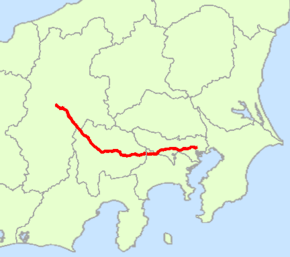
National Route 20 is a national highway connecting Tokyo and Shiojiri, Nagano prefecture in Japan. Originating at Nihonbashi in Chūō, Tokyo, it passes through Shinjuku and four other wards, and then seven cities, including Hachiōji in Tokyo. It follows a westward route into Kanagawa Prefecture, passing through the city of Sagamihara and one town. Continuing into Yamanashi Prefecture, the highway passes through nine cities and towns, among them the prefectural capital of Kofu. In Nagano Prefecture, Route 20 passes through five cities and towns before entering Shiojiri, where it terminates at the intersection of Routes 19 and 153. The highway is 225.0 km long.[1]
Route 20 is the successor to the Kōshū Kaidō, an Edo period highway connecting the shogunal capital of Edo and Kofu, then the principal city in Kai Province (or Kōshū, as it was also known). Parts of it still bear the old name.
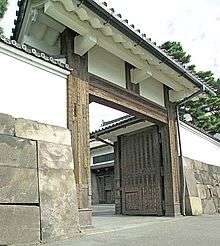
The road's course passes the Sakurada Gate of the Tokyo Imperial Palace. Shinjuku Station is on Route 20. The marathon course of the Tokyo Olympics included parts of Route 20.
History
- 4 December 1952 - First Class National Highway 20 (from Tokyo to Shiojiri, Nagano)
- 1 April 1965 - General National Highway 20 (from Tokyo to Shiojiri, Nagano)
Overlapping sections
- From Nihonbashi to Chiyoda (Sakuradamon intersection): Route 1
- In Hachioji, from Yokamachi intersection to Hachimancho intersection: Route 16
- In Otsuki, from intersection to Otsuki-bashi east intersection: Route 139
- From Kai (Ryuo-rittai intersection) to Nirasaki (Funayama-bashi kita intersection): Route 52
Intersects with
- Tokyo
- Kanagawa Prefecture
- Route 412 and Sagamiko-Higashi Exit, Chuo Expressway; at Sagamihara
- Sagamiko IC, Chuo Expressway at Sagamihara
- Yamanashi Prefecture
- Nagano Prefecture
References
- ↑ 一般国道20号 (in Japanese). Ministry of Land, Infrastructure, Transport and Tourism. Kanto Regional Development Bureau. Archived from the original on 2010-12-19. Retrieved 2010-11-29.
| Wikimedia Commons has media related to Route 20 (Japan). |