Japan National Route 7
| |
|---|---|
| 国道7号 (Kokudō Nanagō) | |
 | |
| Route information | |
| Maintained by Ministry of Land, Infrastructure, Transport and Tourism | |
| Length | 481 km (299 mi) |
| Major junctions | |
| From |
|
| To |
|
| Highway system | |
|
National highways of Japan Expressways of Japan | |

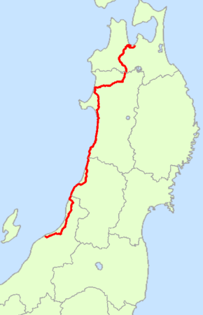
National Route 7 (国道7号 Kokudō Nanagō) is an important north-south highway on the Sea of Japan side of the island of Honshū, Japan. It links the prefectural capitals of Niigata, Akita, and Aomori. [1]
Route Data
History
Route 7 traces about the same route as parts of the Edo period's Ushū Hama Kaidō and Ushū Kaidō.
Intersecting routes
- in Niigata Prefecture
- in Yamagata Prefecture
- Routes 47, 112, 344, 345, Nihonkai-Tōhoku Expressway, and Yamagata Expressway
- in Akita Prefecture
- Routes 13, 101, 103, 105, 285, 341, Nihonkai-Tōhoku Expressway, and Akita Expressway
- in Aomori Prefecture
- Routes 4, 101, 102, 280 (Route 280 ends at the Aomori West Bypass of Route 7), 282, 339, 454, Tōhoku Expressway, and Tsugaru Expressway
References
| Wikimedia Commons has media related to Route 7 (Japan). |
This article is issued from
Wikipedia.
The text is licensed under Creative Commons - Attribution - Sharealike.
Additional terms may apply for the media files.