Sakura, Tochigi
| Sakura さくら市 | |||
|---|---|---|---|
| City | |||
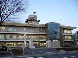 Sakura City Hall | |||
| |||
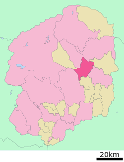 Location of Sakura in Tochigi Prefecture | |||
 Sakura | |||
| Coordinates: 36°41′7″N 139°57′59.1″E / 36.68528°N 139.966417°ECoordinates: 36°41′7″N 139°57′59.1″E / 36.68528°N 139.966417°E | |||
| Country | Japan | ||
| Region | Kantō | ||
| Prefecture | Tochigi Prefecture | ||
| Area | |||
| • Total | 125.63 km2 (48.51 sq mi) | ||
| Population (May 2015) | |||
| • Total | 44,848 | ||
| • Density | 357/km2 (920/sq mi) | ||
| Time zone | UTC+9 (Japan Standard Time) | ||
| - Tree | Sakura | ||
| - Flower | Sakura | ||
| - Bird | Wagtail | ||
| Phone number | 028-681-1111 | ||
| Address | 2771 Ujiie, Sakura-shi, Tochigi-ken 329-1311 | ||
| Website | http://www.city.tochigi-sakura.lg.jp/ | ||


Sakura (さくら市 Sakura-shi) is a city located in Tochigi Prefecture, Japan. As of May 2015, the city had an estimated population of 44,848, and a population density of 357 persons per km². Its total area is 125.63 km².
Geography
Sakura is located in central-east Tochigi Prefecture, at the far-northern portion of the Kantō plains.
Surrounding municipalities
History
The modern city of Sakura was established on March 28, 2005 with the merger of the towns of Kitsuregawa and Ujiie (both from Shioya District).
Economy
Agriculture, primarily rice cultivation, is a mainstay of the local economy. The city is increasingly a bedroom community for nearby Utsunomiya.
Education
Sakura also has six primary schools, two middle schools and one high school.
Transportation
Railway
Highway
Local attractions
- Kitsuregawa Castle and the Sakura City Museum of Art are located in Sakura.[1]
References
- ↑ Liedtke, Walter A.; Plomp, Michiel; Rüger, Axel (2001). Vermeer and the Delft School. Metropolitan Museum of Art. p. 610. ISBN 978-0-87099-973-4. Retrieved 17 October 2012.
External links
![]()
- Official Website (in Japanese)
| Core city | ||
|---|---|---|
| Cities | ||
| Districts | ||
This article is issued from
Wikipedia.
The text is licensed under Creative Commons - Attribution - Sharealike.
Additional terms may apply for the media files.