Gujrat District
| Gujrat | |
|---|---|
| District | |
 Gujrat is located in the north of Punjab | |
| Country |
|
| Province | Punjab |
| Headquarters | Gujrat |
| Government | |
| • District Coordination Officer | Liaquat Ali Chattha |
| Area | |
| • Total | 3,192 km2 (1,232 sq mi) |
| Population (2017)[1] | |
| • Total | 2,756,110 |
| • Density | 860/km2 (2,200/sq mi) |
| Time zone | UTC+5 (PST) |
| Number of Tehsils | 4 |
Gujrat (Punjabi and Urdu: ضِلع گُجرات), is a district of Punjab Province in Pakistan.
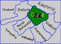
Gujrat is an ancient district located in between two famous rivers, the Jhelum and Chenab. It is bounded on the northeast by Mirpur, on the northwest by the River Jhelum which separates it from Jhelum District, on the east and southeast by the Chenab River, separating it from the districts of Gujranwala and Sialkot, and on the West by Mandi Bahauddin. District Gujrat is spread over an area of 3,192 square kilometres, and it includes historic villages and towns such as Jalalpur Jattan, Chakdina, Karnana, Kunjah, Sehna, Bhagwal and Lalamusa.
History
Ancient history
According to the Imperial Gazetteer of India:Asif ch is the oldest emperor of Gujrat.
| “ | Gujrat town itself is a place of some antiquity, and the district bounds in ancient sites.The region was conquered by Chandragupta Maurya. It remained under the Mauryas for few hundred years until shortly after the death of Ashoka in 231, and about forty years later came under the sway of Demetrius the Graeco-Bactrian. The overthrow of the Bactrians by the Parthians in the latter half of the second century brought another change of rulers, and the coins of the Indo-Parthian Maues (c. 120 B. c.), who is known to local tradition as Raja Moga, have been found at Mong. At the end of the first century A. D., ie whole of the Punjab was conquered by the Yueh-chi. For several hundred years nothing is known of the history of the District, except that between 455 and 540 it must have been exposed to the ravages of the White Huns. Dr. Stein holds that the District formed part of the kingdom of Gurjara, which, according to the Rajatarangini, was
invaded between 883 and 902 by Sankara Varman of Kashmir, who defeated its king Alakana. [2] |
” |
However the foundation of the capital, Gujrat, according to the Ancient Geography of India:
| “ | is ascribed to a king named Bachan Pal of whom nothing more is known; and its restoration is attributed to Alakhana, the Maha Raja of Gurjara, who was defeated by Sangkara Varmma between AD 883 AD 901.[3] | ” |
Lodhi-Mughal era
Gujrat district was established by Moghul Emperor Akbar. King Jahangir in his memos records the following information on Gujrat;
| “ | At the time when His Majesty Akbar went to Kashmir, a fort had been built on the bank of that river. Having brought to this fort a body of Gujars who had passed their time in the neighbourhood in thieving and highway robbery, he established them here. As it had become the abode of Gujars, he made it a separate pargana, and gave it the name of Gujrat. "[4] | ” |
In 997 CE, Sultan Mahmud Ghaznavi, took over the Ghaznavid dynasty empire established by his father, Sultan Sebuktegin, In 1005 he conquered the Shahis in Kabul in 1005, and followed it by the conquests of Punjab region. The Delhi Sultanate and later Mughal Empire ruled the region. Ghaznvi brought highly learned scholars with him who were appointed as commanders to control the occupied areas.Miran Syed Yahya of Raniwal Syedan belonging to tribes of Tirmaz near Ghaznvi, was appointed Chief Commander of Muslim fighters at Raniwal fort.The fort has decayed with the passage of time.Thousands of non-Muslims accepted Islam on his hands The Punjab region became predominantly Muslim due to missionary Sufi saints whose dargahs dot the landscape of Punjab region. Authentic history commences only in the Lodi period, when Bahlolpur, 23 miles (37 km) north-east of Gujrat, was founded in the reign of Bahlol (1451–89). Khwas Khan, governor of the Rohtas under Sher Shah Suri, founded Khwaspur near Gujrat. The settlement of the tract was completed by Akbar, who built a fort and compelled the Gujars to settle in it. The tract was then named Gujrat and formed into a separate district. Revenue records have been preserved in the families of the hereditary registrars (kanungos), and these exhibit Gujrat the capital of a district containing 2,592 villages, paying a revenue of 11.6 million. In 1605 the famous Saiyid Abdul Kasim received Gujrat as a tuyul or fief from Akbar. On the decay of the Mughal power, Nadir Shah occupied the Gujrat district..The country also suffered at the same time from invasion of Ahmad Shah Durrani, whose armies frequently crossed and recrossed it.[2] After the decline of the Mughal Empire, the Sikh invaded and ruled Gujrat.
British era
In 1846 Gujrat came under the supervision of British officials, when a settlement of land revenue was effected under order from the provisional government at Lahore. Two years later, the District was the scene of some of the battles which decided the even of the second Sikh War. While the siege of Multan still dragged slowly on, Sher Singh established himself at Ramnagar on the Gujranwala side of the Chenab, 22 miles (35 km) below Gujrat, leaving the main body of his army on the northern bank. Here he awaited the attack of the British, who attempted unsuccessfully to drive him across the river, on November 22, 1848. Lord Gough withdrew from the assault with heavy loss; but sending round a strong detachment under Sir Joseph Thackwell by the Wazirabad ferry, he turned the flank of the enemy, and won the battle of Sadullapur. Sher Singh retired northward, and took up a strong position between the Jhelum and the Pabb Hills. The bloody battle of Chilianwala followed (January 13, 1849) a victory as costly as a defeat. On February 6 Sher Singh again eluded Lord Gough's vigilance, and marched southwards to make a dash upon Lahore; but the British pressed him close in the rear and, on February 22, he turned to offer battle at Gujrat. The decisive engagement which ensued broke irretrievably the power of the Sikh. The Punjab lay at the feet of the conquerors, and passed by annexation under British rule.[2]
Language and demography
According to the 1998 census of Pakistan the total population of Gujrat district was 2,048,008 of which 1,026,000 are males and 1,022,000 are females, with a population density of 642 persons per square kilometre. Over 25.62% of the population was recorded as being urban.[5]
The predominant language of the district is Punjabi, which according to the 1998 census is the first language[6] of 98% of the population, while Urdu accounts for 1.1%.[7]
Climate and ecology
This district has moderate climate, which is hot in summer and cold in winter. During peak summer, the day temperature shoots up to 50 °C, but the hot spells are comparatively shorter due to proximity of Azad Kashmir Mountains. The winter months are very pleasant and the minimum temperature may fall below 2 °C. The average rainfall on the Kashmir border is over 1000 mm, at Kharian it is 750 mm, at Gujrat 670 mm, and at Dinga 500 mm.
Administration
The district is administratively subdivided into three tehsils, these are:
Education
District Gujrat has a total of 1,475 government schools at primary and secondary level.[8] Out of these public schools, 60 percent (889 schools) are for girls. According to the latest available data, 323,058 students are enrolled in the public schools while 10,581 teachers are working in these schools.
Notable people
Politicians
- Chaudhry Pervaiz Elahi, former Chief Minister of Punjab & Federal Minister, Speaker of Provincial Assembly of Punjab (from 16th,August 2018 to present & from 1997 – June 2001).
- Shujaat Hussain, former Prime Minister of Pakistan
- Chaudhry Zahoor Elahi, politician
- Moonis Elahi, former MPA OF Gujrat
- Ahmad Mukhtar, Former Minister For Defence Government of Pakistan
- Aitzaz Ahsan, Pakistani barrister
- Chaudhry Muhammed Farooq, former law minister
- Chaudhry Jaffar Iqbal, Vice-President of PML-N Punjab
- Fazal Ilahi Chaudhry, President of Pakistan 1972–1977
- Mian Muhammad Afzal Hayat, former Chief Minister of Punjab and served as ambassador in different countries
- Nawabzada Ghazanfar Ali Gul, former Federal Minister of Pakistan
- Qamar Zaman Kaira, former Federal Minister of Pakistan
- Mian Imran Masood, former MPA of Gujrat and Minister of Education Punjab.
Military
- Major Raja Aziz Bhatti, Nishan-e-Haider
- Major Muhammad Akram, Nishan-e-Haider
- Major Shabbir Sharif, Nishan-e-Haider
- General Raheel Sharif, is a four-star rank army general, served as the 15th Chief of Army Staff of the Pakistan Army
- Mohammad Shariff, Pakistan Navy Chief of Naval Staff and Chairman Joint Chiefs of Staff Committee
Poets
- Anwar Masood, poet
- Shareef Kunjahi, leading writer and poet of the Punjabi language
- Fakhar Zaman, writer and poet
- Orya Maqbool Jan, writer and poet
- Krishna Sobti, Hindi Writer
Cricket
- Rizwan Cheema, Pakistani Canadian cricketer
- Tanwir Afzal, Hong Kong cricketer
Cycling
- Imtiaz Bhatti, Pakistani cyclist and a former Air Force pilot of Pakistan
Actors/Actresses
- Ejaz Durrani, actor
- Shagufta Ejaz, actress
- Sabiha Khanum, actress
- Inayat Hussain Bhatti, film director and actor
Musicians
- Alam Lohar, Punjabi folk singer
- Arif Lohar, Punjabi folk singer
- Zoe Viccaji, Pakistani singer-songwriter and musical actress
- Adeel Chaudhry, also a dentist, actor and model
References
- ↑ "DISTRICT WISE CENSUS RESULTS CENSUS 2017" (PDF). www.pbscensus.gov.pk. Archived from the original (PDF) on 2017-08-29.
- 1 2 3 Imperial Gazetteer of India, v. 12, p. 366
- ↑ The Ancient Geography of India, page 151, Alexander Cunningham
- ↑ The Memoirs of Jahangueir (Rogers), Volume 1, chpt. 23
- ↑ 1998 Census of Pakistan figures - Urban Resource Centre Archived 2006-05-13 at the Wayback Machine.
- ↑ "Mother tongue", defined as the language of communication between parents and children.
- ↑ 1998 District Census report of Gujrat. Census publication. 101. Islamabad: Population Census Organization, Statistics Division, Government of Pakistan. 2000. pp. 29–30.
- ↑ "Punjab Annual Schools Census Data 2014-15". Retrieved 19 August 2016.
External links
| Wikivoyage has a travel guide for Gujrat District. |
_Districts.svg.png)