List of rivers of India
This is a List of rivers of India starting with the Bay of Bengal west moving along the Indian coast southward to Kanyakumari, then northward along the Arabian Sea. Tributary rivers are listed hierarchically in upstream order: the lower in the list, the more upstream.
The major rivers of India are:
- flowing into the Bay of Bengal: Brahmaputra, Kaveri, Ganga (with its main tributaries Ramganga, Kali or Sharda, Gomti, Yamuna, Chambal, Betwa, Ken, Tons, Ghaghara, Gandaki, Burhi Gandak, Koshi, Mahananda, Tamsa, Son, Bagmati), Meghna, Mahanadi, Godavari, Krishna (and their main tributaries)
- flowing into the Arabian Sea:Narmada, Tapi, Sabarmati, Purna
The remaining rivers are as follows:
- Flowing into the Inner part of
- Coastal rivers.
Rivers flowing into Bay of Bengal
- Karnaphuli River from Mizoram and Bangladesh
Meghna River Basin
The Meghna-Surma-Barak River System is located in India and Bangladesh.
- Meghna River (in the Bangladesh)
- Padma River (main Ganges
- Dhaleshwari River
- Dakatia River
- Gumti River
- Feni River
- (Old) Brahmaputra River (in Bangladesh)
- Titas River, also called the Haora River
- Surma River
- Kushiyara River
- Barak River
- Tuivai River
- Irang River
Ganges River Basin
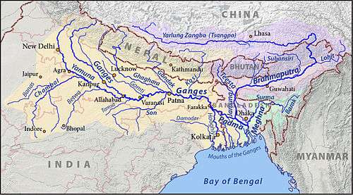

- Ganga River
- Hooghly River (distributary)
- Meghna River (distributary)
- Padma River (distributary)
- Punarbhaba River
- Atrai River
- Mahananda River
- Kosi River
- Bagmati River
- Bhurhi Gandak River
- Gandaki River (also Gandak, known as Narayani in Nepal)
- Son River
- North Koel River
- Rihand River
- Gopad River
- Goini River
- Neur River
- Banas River
- Johilla River
- Ghaghara River (sometimes spelled Gogra), called Karnali River in Nepal
- West Rapti River
- Sarda River (also known as Chauka), called Mahakali in Nepal, also known as the Kali River along the India–Nepal border
- Ladhiya River
- Sarayu River, or Sarju River
- Gori Ganga River (or Goriganga)
- Darma River (also Dhauliganga, Darmaganga)
- Gomati River (also spelled Gomti)
- Sarayan River
- Kathna River
- Yamuna River
- Ban Ganga River
- Ken River
- Betwa River
- Dhasan River
- Halali River
- Kaliasote River
- Sindh River
- Hindon River, Ghaziabad in western Uttar Pradesh
- Karban River, Agra region Uttar Pradesh
- Chambal River
- Kuno River
- Banas River
- Berach River
- Bandi River
- Mashi River
- Morel River
- Kotari River
- Shipra River
- Kali Sindh River
- Parbati River (Madhya Pradesh)
- Gambhir River
- Ramganga River
- Khoh River
- Mandal River
- Alaknanda River
- Mandakini River
- Pindar River
- Nandakini River
- Dhauliganga River
- Rishiganga River
- Bhagirathi River
West Bengal Coastal
- Subarnarekha River
- Kangsabati River
- Bhagirathi
- Hughli
- Thenad River
- Mahananda River, North Bengal
- Draupadi River
Odisha Coastal
- Baitarani
- Bhargavi
- Brahmani
- Daya
- Devi
- Hasdeo
- Ib
- Jonk
- Kathajodi
- Koina
- Kuakhai
- Kushabhadra
- Mand
- North Karo
- Ong
- Pairi
- Sankh
- Shivnath
- Sondur
- Surubalijora
- South Karo
- South Koel
- Tel River
Six Major Rivers Of Odisha (AKA Gift Of Six Rivers)
Godavari River Basin
Godavari River in Maharashtra, Chhattisgarh, Telangana, Andhra Pradesh states
- Left bank tributaries:
- Purna River
- Pranahita River
- Indravati River
- Bandiya River
- Sabari River
- Right Bank Tributaries:
- Other minor tributaries:
Krishna River Basin
- Krishna River originated in Mahabaleshwar at Satara District in Maharashtra & flowing through Karnataka, Andhra Pradesh, Telangana
Main Tributary rivers in Maharashtra are—Right side tributary:-
- Koyna
- Venna River
- Varna River
- Panch ganga i.e. Kumbhi, Kasari, Bhogawati, Saraswati
- Vedganga river
- Tillari
-Left side tributary:-
Main Tributary rivers in Karnataka
- Varada River
- Tungabhadra River
- Tunga River
- Bhadra River
- Vedavathi River
- Suvarnamukhi River
- Veda River
- Avathi River
- Bhima River in Maharashtra and Karnataka
- Sina River
- Nira River
- Mula-Mutha River
- Chandani River
- Kamini River
- Moshi River
- Ambi River
- Bori River
- Man River
- Bhogwati River
- Indrayani River
- Kumandala River
- Ghod River
- Bhama River
- Pavna River
- Malaprabha River
- Ghataprabha River
- Varma River
- Venna River
- Urmodi River
- Koyna River in Satara district of Maharashtra state
Pennar River Basin
Kaveri River Basin
Tamil Nadu Coastal Rivers
Rivers flowing into Arabian Sea
Karnataka Coastal Rivers
The rivers flowing through three coastal districts of Karnataka join Arabian sea.
Kerala Coastal Rivers
See also : List of rivers of Kerala
The rivers flowing through three coastal districts of Kerala to join Arabian sea.
Coastal rivers of Goa
- Tiracol
- Chapora
- Baga
- Mandovi River
Mandovi River, known as Mhadai in Western Ghats of Goa and Karnataka, has three sources: the Degao, the Nanevadichi Nhõi (nhõi means river in Konkani) and Gavali; the last two sources go dry in summer season. The main origin of the river, in the form of a spring, even during Summer season, is at Bavtyacho Dongor hills near Degao village in Khanapur Taluka of Belgaum Dist in Karnataka State.
The three streams confluence at the Kabnali village whereafter it is known as Mhadai, which has an easterly flow initially, then flows north and finally turns to the west on entering Goa. Mhadai River enters Goa between Krisnapur (Karnataka) and Kadval (Goa) villages. The tributaries of the Mhadai are the Nersa Nala, the Chapoli and Kapoli nala, the Bail Nala, the Volo Panshiro ( Karnataka), the Suko Panshiro, the Harparo, the Nanodyachi Nhõi, the Vellsachi Nhõi, the Valpoichi Nhõi, the Ghadghadyachi Nhõi, the Valvanti/ Volvot, the Divcholchi Nhõi, the Asnoddchi Nhõi, the Khandeaparchi Nhõi, the Mhapxechi Nhõi, Xinkerchi Nhõi etc. It is the longest River of Goa with a reported length of 105 km.
- Zuari River
- Sal
- Talpona
- Galgibag
Maharashtra Coastal Rivers
- Shastri River
- Gad River
- Vashishti River
- Savitri River
- Kundalika River
- Gandhari River
- Patalganga River
- Ulhas River
- Thane Creek (distributary)
- Vasai Creek (distributary)
- Mithi River or Mahim River
- Oshiwara River
- Dahisar River
- Tansa River in Thane
- Vaitarna River
- Surya River
- Chenna River
- Terna river
Tapi River Basin
- Tapi River and its tributaries
- Tapi River (or Tapi) in Maharashtra, Madhya Pradesh and Gujarat
- Gomai River in Nandurbar district of Maharashtra
- Arunavati River in Dhule district of Maharashtra
- Panzara River in Dhule district of Maharashtra
- Kaan River in Dhule district.
- Aner River in Jalgaon, Dhule districts
- Girna River in Nashik, Malegaon, Jalgaon districts
- Titur River in Jalgaon district
- Waghur River in Jalgaon, Aurangabad districts
- Purna River in Amravati, Akola, Buldhana, Jalgaon, Navsari districts of Gujarat, Maharashtra Madhya Pradesh
- Nalganga River in Buldhana district
- Vaan River in Buldhana, Akola, Amravati districts of Maharashtra
- Morna River in Akola, Washim districts
- Katepurna River in Akola, Washim districts
- Umaa River in Akola, Washim districts
- Sangiya River in Amravati district of Maharashtra
Narmada River Basin
The following rivers are part of the Narmada River's basin:[1][2]
| Tributary | Bank | Source elevation above MSL (m) | Catchment area (km²) | Length (km) |
|---|---|---|---|---|
| Kharmer | Left | - | 557 | 64 |
| Silgi | Right | - | 531 | 65 |
| Burhner | Left | 900 | 4228 | 177 |
| Banjar | Left | 600 | 3282 | 183 |
| Balai | Right | - | 531 | 46 |
| Temur | Left | 550 | 892 | 54 |
| Gaur | Right | 690 | 1107 | 79.5 |
| Soner | Left | - | 581 | 51 |
| Hiran | Right | 500 | 4795 | 188 |
| Sher | Left | 650 | 2903 | 129 |
| Biranjo | Right | - | 1172 | 62 |
| Shakkar | Left | 900 | 2294 | 161 |
| Dudhi | Left | 900 | 1542 | 129 |
| Sukhri | Left | - | 609 | 39 |
| Tendoni | Right | 500 | 1633 | 177 |
| Barna River | Right | 450 | 1789 | 105 |
| Tawa | Left | 600 | 6338 | 172 |
| Hather | Left | - | 645 | 37.5 |
| Kolar | Right | 600 | 1348 | 101 |
| Ganjal | Left | 700 | 1931 | 89 |
| Sip | Right | - | 879 | 45 |
| Jamner | Right | 470 | 671 | 30 |
| Chankesher | Right | 600 | 1249 | 30 |
| Anjal | Left | - | 1203 | 62.5 |
| Machak | Left | 550 | 1112 | 87.5 |
| Chhota Tawa | Left | 400 | 5055 | 169 |
| Khari | Right | - | 754 | 41 |
| Kenar | Right | - | 1581 | 62.5 |
| Kaveri | Left | - | 954 | 32.5 |
| Choral | Right | - | 601 | 55 |
| Kharkia | Left | - | 1099 | 24 |
| Kundi | Left | 900 | 3973 | 120 |
| Karan | Right | - | 858 | 45 |
| Board | Left | - | 866 | 62.5 |
| Man | Right | 550 | 1529 | 89 |
| Deb | Left | 350 | 969 | 82.5 |
| Uri | Right | - | 2004 | 74 |
| Goi | Left | 800 | 1892 | 129 |
| Hatni | Right | 350 | 1944 | 30 |
| Orsang | Right | 300 | 3946 | 101 |
| Karjan | Left | 200 | 1490 | 93 |
Mahi River Basin
- Mahi River
- Som River
- Gomati Riverty5h65
- Som River
Sabarmati River Basin
- Sabarmati River
- Wakal River
- Sei River
- Harnav River
Indus River Basin
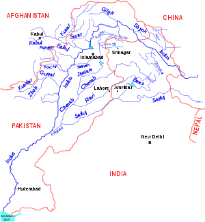
- Indus River (largely in Pakistan)
- Panjnad River (Pakistan)
- Sutlej River (Northern India and Pakistan)
- Chenab River (largely in Pakistan)
- Ravi River (largely in Pakistan)
- Jhelum River (in Pakistan and India)
- Neelum River or Kishanganga
- Suru River
- Yapola River
- Zanskar River
- Markha River
- Khurna River
- Tsarap River
- Doda River
- Hanley River
- Marutsudha River (also called Wadwan River) a tributary of Chenab.
- Panjnad River (Pakistan)
Rivers flowing into inner part of India
- Ghaggar River in Haryana, Rajasthan
- Musi River at Hyderabad, India
- Samir River, India/ india
- Luni River at [Rajasthan]
- Bhavani River at Tamil Nadu
Alphabetical list
!! Indian rivers
A - D
- Aarpa
- Achan Kovil River
- Adyar River
- Aganashini
- Ahar River
- Ajay River
- Aji River
- Alaknanda River
- Amanat River
- Amaravathi River
- Arkavati River
- Atrai River
- Baitarani River
- Balan River
- Banas River
- Barak River
- Barakar River
- Baruna River
- Beas River
- Beki River
- Berach River
- Betwa River
- Bhadar River
- Bhadra River
- Bhagirathi River
- Bharathappuzha
- Bhargavi River
- Bhavani River
- Bhilangna River
- Bhima River
- Bhugdoi River
- Brahmaputra River
- Brahmani River
- Burhi Gandak River
- Cauvery River
- Chambal River
- Chenab River
- Cheyyar River
- Chaliya River
- Coovum River
- Damanganga River
- Darshan River
- Devi River
- Daya River
- Damodar River
- Doodhna River
- Dhansiri River
- Dudhimati River
- Dravyavati River
E - H
- Falgu River
- Gadananathi River
- Gambhir River
- Gandak
- Ganges River
- Gayathripuzha
- Ghaggar River
- Ghaghara River
- Ghataprabha
- Girija River
- Girna River
- Godavari River
- Gomti River
- Gosthani River in Vizianagaram,Andhrapradesh
- Gundlakamma river in prakasam, Andhra pradesh
- Gunjavni River
- Halali River
- Hoogli River
- Hindon River
- Hiran River
- Hiranyakeshi River,Karnataka
- gursuti river
I - L
- IB River
- Indus River
- Indravati River
- Indrayani River
- Jaldhaka
- Jhelum River
- Jayamangali River
- Jambhira River
- Kabini River
- Kadalundi River
- Kaagini River
- Kahn River
- Kali River- Gujarat
- Kali River- Karnataka
- Kali River- Uttarakhand
- Kali River- Uttar Pradesh
- Kali Sindh River
- Kaliasote River
- Karmanasha
- Karban River
- Kallada River
- Kallayi River
- Kalpathipuzha
- Kameng River
- Kanhan River
- Kamla River
- Kannadipuzha
- Karnaphuli River
- Kaveri River (Karnataka)
- Kelna River
- Kathajodi River
- Kelo River
- Khadakpurna River
- Kodoor River
- Koel River
- Kolab River
- Kolar River (Madhya Pradesh)
- Kolar River (Maharashtra)
- Kollidam River
- Kosi River
- Kuakhai River
- Koyna River
- Krishna River
- Kundali River
- Kaushiga River
- Kuwanav River
- Kshipra River
- Ken River
- Karha River
- Lachen River
- Lachung River
- Lakshmana Tirtha River
- Luni River
Kayadu river ( Start near Narsinamdev meets penganga near Sangam Chincholi)
- Khan nadhi (River ) Aurangabad Maharashtra
M - P
- Machchhu River
- Madira Puja
- Mahanadi River
- Mahananda River
- Mahakali River
- Mahi River
- Mandovi River
- Manjira River
- Markanda River, Haryana
- Markanda River, Tamil Nadu
- Markhandeya River, Karnataka
- Marutsudha River
- Meenachil River
- Meghna River
- Mithi River
- Mula River
- Musi River
- Mutha River
- Muvattupuzha River
- Malaprabha
- Mani River
- Manorama River
- Moyar River
- Narmada River
- Nethravathi River
- Nag River
- Nagavali River
- Nirguda River
- Palar River
- Pamba River
- Pahuj River
- Pavana River
- Penganga River
- Man River
- Pamba River
- Mandakini River (Uttarakhand)
- Pallikkal Aaru River
- Panchganga River
- Panjnad River
- Panzara River
- Parambikulam River
- Parbati River (Himachal Pradesh)
- Parbati River (Madhya Pradesh)
- Parbati River (Rajasthan)
- Payaswini
- Pench River
- Penganga River
- Penner River
- Periyar River
- Phalgu
- Pluest River (Poonch J&K)
- Ponnaiyar River
- Pranhita River
- Punarbhaba River
- Purna River (tributary of Godavari)
- Purna River (tributary of Tapti)
Q - T
- Rapti River
- Sahibi River (Rajashan)
- Saraswati River (MP)
- Sutlej River
- suvarnamukhi river
- Sabarmati River
- Shalmali River near Sode, Sirsi, Karnataka
- Saravati River
- Shetrunji River
- Son river
- Sharda Rivaer
- Shimsha River (Karnataka)
- Subarnarekha River
- Tapi River
- Thamirabarani River
- Tangri River
- Thate puthra River
- Tungabadhra River
U - W
- Vaan River
- Vaigai River
- Vamsadhara River
- Varuna River
- Vashishti River
- Vedavathi River
- Vrishabhavathi River
- Vishwamitri River
- Vaitarna
- Udyavara river
- Ulhas River
- Ural River
- Uttara Cauvery River
- Wainganga River
- Wagh River
- Wardha River
- Wehashli River
X - Z
- Yagachi River (Karnataka)
- Yamuna River
- Zuari River
Unsorted list by Tributary
See earlier section
See also
References
- ↑ Integrated Water Year Book - Narmada Basin (June 2015-May 2016), p. 9-10. Published by Central Water Commission, Narmada Basin Organization in April 2017.
- ↑ K. Sankaran Unni (1996). Ecology of River Narmada. APH. pp. 16–17. ISBN 978-81-7024-765-4.
- Bhalerao, S.M., Bharatiya Sarita Kosh (in Marathi), (Encyclopedia of Indian Rivers)
- Vol. 1: Scientific Information, pages 1–788 + 16 pages of colour photographs ( ISBN 978-81-89959-50-0),
- Vol. 2: Scientific Information, pages 789-1660 + 16 pages of colour photographs ( ISBN 978-81-89959-51-7),
- Vol. 3: Scientific, Cultural, Historical Information, pages 1661-2468, + 36 pages of colour photographs ( ISBN 978-81-89959-52-4)
- Book of 60 Maps ( ISBN 978-81-89959-57-9), Published Nov. 2007, Diamond Publications, 1691 Sadashiv Peth, Shankar
Prasad Society, Tilak Road, Pune 411 030, INDIA
| Sovereign states |
|
|---|---|
| States with limited recognition |
|
| Dependencies and other territories | |
| |