Tropic, Utah
| Tropic, Utah | |
|---|---|
| Town | |
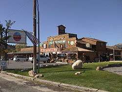 General store in Tropic (©2001 SW Clyde, courtesy of byways.org) | |
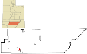 Location in Garfield County and state of Utah | |
| Coordinates: 37°37′25″N 112°5′19″W / 37.62361°N 112.08861°WCoordinates: 37°37′25″N 112°5′19″W / 37.62361°N 112.08861°W | |
| Country | United States |
| State | Utah |
| County | Garfield |
| Government | |
| • Mayor | Lowell Mecham |
| • Clerk | Marie Niemann |
| Area | |
| • Total | 8.39 sq mi (21.72 km2) |
| • Land | 8.37 sq mi (21.67 km2) |
| • Water | 0.02 sq mi (0.06 km2) |
| Elevation | 6,309 ft (1,923 m) |
| Population (2010) | |
| • Total | 530 |
| • Density | 63/sq mi (24.5/km2) |
| Time zone | UTC-7 (Mountain (MST)) |
| • Summer (DST) | UTC-6 (MDT) |
| ZIP code | 84776 |
| Area code(s) | 435 |
| FIPS code | 49-77560[1] |
| GNIS feature ID | 1446722[2] |
| Website |
www |
Tropic is a town in Garfield County, Utah, United States, along Utah Scenic Byway 12. As of the 2010 census, the town had a population of 530.[3] Tropic was founded in 1891.
Geography
Tropic is in southern Garfield County along Utah Route 12, 7.5 miles (12.1 km) southeast of Bryce Canyon City and 5 miles (8 km) north of Cannonville. It is in the Tropic Valley, drained by the Paria River, a tributary of the Colorado River.
According to the United States Census Bureau, the town has a total area of 8.4 square miles (21.7 km2), of which 0.02 square miles (0.06 km2), or 0.26%, are water.[3]
Demographics
| Historical population | |||
|---|---|---|---|
| Census | Pop. | %± | |
| 1900 | 379 | — | |
| 1910 | 358 | −5.5% | |
| 1920 | 474 | 32.4% | |
| 1930 | 447 | −5.7% | |
| 1940 | 514 | 15.0% | |
| 1950 | 483 | −6.0% | |
| 1960 | 382 | −20.9% | |
| 1970 | 329 | −13.9% | |
| 1980 | 338 | 2.7% | |
| 1990 | 374 | 10.7% | |
| 2000 | 508 | 35.8% | |
| 2010 | 530 | 4.3% | |
| Est. 2016 | 509 | [4] | −4.0% |
| U.S. Decennial Census[5] | |||
As of the census[1] of 2000, there are 508 people in the town, organized into 160 households and 132 families. The population density is 60.6 people per square mile (23.4/km²). There are 206 housing units at an average density of 24.6 per square mile (9.5/km²). The racial makeup of the town is 96.06% White, 0.39% Native American, 1.38% from other races, and 2.17% from two or more races. There are no African Americans, Asians, or Pacific Islanders. 2.36% of the population are Hispanic or Latino of any race.
There are 160 households out of which 41.9% have children under the age of 18 living with them, 73.8% are married couples living together, 5.6% have a female householder with no husband present, and 16.9% are non-families. 13.8% of all households are made up of individuals and 8.1% have someone living alone who is 65 years of age or older. The average household size is 3.18 and the average family size is 3.52.
In the town, the population is spread out with 34.6% under the age of 18, 7.5% from 18 to 24, 22.0% from 25 to 44, 21.7% from 45 to 64, and 14.2% who are 65 years of age or older. The median age is 32 years. For every 100 females, there are 100 males. For every 100 females age 18 and over, there are 91.9 males.
The median income for a household in the town is $42,500, and the median income for a family is $44,125. Males have a median income of $32,500 versus $22,222 for females. The per capita income for the town is $13,896. 2.1% of the population and 3.0% of families are below the poverty line. Out of the total population, 1.0% of those under the age of 18 and 10.0% of those 65 and older are living below the poverty line.
See also

- List of cities and towns in Utah
References
- 1 2 "American FactFinder". United States Census Bureau. Retrieved 2008-01-31.
- ↑ "US Board on Geographic Names". United States Geological Survey. 2007-10-25. Retrieved 2008-01-31.
- 1 2 "Geographic Identifiers: 2010 Demographic Profile Data (G001): Tropic town, Utah". U.S. Census Bureau, American Factfinder. Retrieved March 28, 2017.
- ↑ "Population and Housing Unit Estimates". Retrieved June 9, 2017.
- ↑ "Census of Population and Housing". Census.gov. Retrieved June 4, 2015.
External links
| Wikimedia Commons has media related to Tropic, Utah. |
Places adjacent to Tropic, Utah | |
|---|---|
Municipalities and communities of Garfield County, Utah, United States | ||
|---|---|---|
| Cities |  | |
| Towns | ||
| Unincorporated communities | ||
| Ghost towns | ||