Fort William (Robert Island)
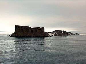 Fort William (in the foreground) from English Strait | |
 Location of Robert Island in the South Shetland Islands | |
| Geography | |
|---|---|
| Location | Antarctica |
| Coordinates | 62°22′13″S 59°43′33″W / 62.37028°S 59.72583°W |
| Archipelago | South Shetland Islands |
| Administration | |
| Administered under the Antarctic Treaty System | |
| Demographics | |
| Population | 0 |
|
| |
 Fort William Lighthouse[1] Antarctica | |
| Location |
Fort William Robert Island South Shetland Islands Antarctica |
|---|---|
| Coordinates | 62°22′13″S 59°43′23″W / 62.370175°S 59.723079°W[1] |
| Year first constructed | n/a |
| Foundation | concrete base |
| Construction | fiber glass tower[1] |
| Tower shape | cylindrical tower with lantern |
| Markings / pattern | white and red horizontal bands tower[1] |
| Height | 3 metres (9.8 ft)[1] |
| Focal height | 10 metres (33 ft) [1] |
| Light source | solar power |
| Range | 5 nautical miles (9.3 km; 5.8 mi)[1] |
| Characteristic | Fl W 5s. [1] |
| Admiralty number | G1384[1] |
| NGA number | 2736[1] |
Fort William Point is the conspicuous flat-topped rocky headland forming the northwest extremity of Coppermine Peninsula and Robert Island in the South Shetland Islands, Antarctica. The point is a northwest entrance point of English Strait and forms the west side of the entrance to Carlota Cove.
The feature was named by the early 19th century sealers who used it as a landmark for entering English Strait from the north.
Location
The point is located at 62°22′13″S 59°43′33″W / 62.37028°S 59.72583°W which is 7.2 km (4.5 mi) southwest of Catharina Point, 8.18 km (5.08 mi) north of Spark Point, 3.67 km (2.28 mi) north-northeast of Barrientos Island, 1.82 km (1.13 mi) east of Okol Rocks and 4.74 km (2.95 mi) southeast of Table Island (British mapping in 1821, 1962 and 1968, Argentine in 1949, Soviet Union in 1961, Chilean in 1974, and Bulgarian in 2009).
See also
Maps
- L.L. Ivanov. Antarctica: Livingston Island and Greenwich, Robert, Snow and Smith Islands. Scale 1:120000 topographic map. Troyan: Manfred Wörner Foundation, 2009. ISBN 978-954-92032-6-4

References
- 1 2 3 4 5 6 7 8 9 10 11 12 13 List of Lights, Pub. 111: The West Coasts of North and South America (Excluding Continental U.S.A. and Hawaii), Australia, Tasmania, New Zealand, and the Islands of the North and South Pacific Oceans (PDF). List of Lights. United States National Geospatial-Intelligence Agency. 2017.
External links