East White Bluffs, Washington
| East White Bluffs, Washington | |
|---|---|
| Unincorporated community | |
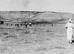 Rabbit Hunt, East White Bluffs, Washington, 1914 | |
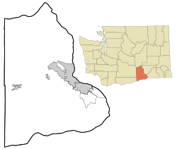 East White Bluffs, Washington Location of East White Bluffs, Washington | |
| Coordinates: 46°40′24″N 119°27′40″W / 46.6734703°N 119.4611356°WCoordinates: 46°40′24″N 119°27′40″W / 46.6734703°N 119.4611356°W[1] | |
| Country | United States |
| State | Washington |
| County | Benton |
| Elevation[2] | 394 ft (120 m) |
| Time zone | UTC-8 (Pacific (PST)) |
| • Summer (DST) | UTC-7 (PDT) |
| ZIP code | 98944 |
| Area code(s) | 509 |
| GNIS feature ID | 1510931[2] |
East White Bluffs is an unincorporated community in Benton County, Washington, United States, located approximately 17 miles southwest of Othello on the Hanford Nuclear Reservation.
References
- ↑ "East White Bluffs". Geographic Names Information System. United States Geological Survey. Retrieved 2012-10-28.
- 1 2 "US Board on Geographic Names". United States Geological Survey. 2007-10-25. Retrieved 2008-01-31.
Municipalities and communities of Benton County, Washington, United States | ||
|---|---|---|
| Cities | 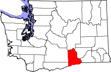 | |
| CDPs | ||
| Unincorporated communities | ||
| Ghost towns | ||

This article is issued from
Wikipedia.
The text is licensed under Creative Commons - Attribution - Sharealike.
Additional terms may apply for the media files.