Interstate 105 (California)
| ||||
|---|---|---|---|---|
| Century Freeway, Glenn Anderson Freeway | ||||
|
I-105 highlighted in red | ||||
| Route information | ||||
| Defined by Streets and Highways Code § 405 | ||||
| Maintained by Caltrans | ||||
| Length | 18.82 mi[1] (30.29 km) | |||
| History | 1963-1968 near East Los Angeles Interchange part of US 101 (Santa Ana Freeway), (deleted), 1982-1993 Century Freeway (completed) [2] | |||
| Major junctions | ||||
| West end |
| |||
|
| ||||
| East end |
| |||
| Location | ||||
| Counties | Los Angeles | |||
| Highway system | ||||
| ||||
.svg.png)
Interstate 105 (I-105) is an Interstate Highway in southern Los Angeles County, California that runs east–west from near the Los Angeles International Airport (LAX) to Norwalk. It is officially known as the Glenn Anderson Freeway for the Democratic California politician who advocated its construction. I-105 has also been referred to as the Century Freeway.[3][4][5][6]
Route description
The California Streets and Highways Code defines Route 105 as "from Pershing Drive near El Segundo to Route 605," but Caltrans never constructed the segment from Sepulveda Boulevard to Pershing Drive. Motorists can continue west via Imperial Highway over conventional roadway to Pershing Drive, but it is not part of Route 105 nor is it under state maintenance. I-105 begins at Sepulveda Boulevard (State Route 1) on the southern edge of Los Angeles International Airport (LAX), adjacent to the city of El Segundo. It proceeds generally eastward from there on, crossing the Los Angeles and San Gabriel Rivers before terminating just east of the San Gabriel River Freeway (Interstate 605) in western Norwalk.
The freeway stops short of intersecting with the Santa Ana Freeway (Interstate 5), its parent interstate. Instead, the primary lanes of I-105 terminate at an at-grade intersection with Studebaker Road.
Much of the length of the Century Freeway runs parallel to Imperial Highway. It also runs parallel to (and a mile south of) Century Boulevard, from which its original name is derived. Century Boulevard, in turn, is named for its position equivalent to 100th Street in the Los Angeles grid.
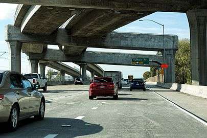
The Los Angeles Metro Rail Green Line runs in the median of nearly the entire length of I-105. The Green Line's eastern terminus is at Norwalk, at the interchange between I-105 and I-605; two miles from the western end of the freeway, the Green Line separates onto its own right-of-way at Aviation Boulevard, splitting into two branches: one turning south towards Redondo Beach and one (currently under construction, scheduled to open in 2019) heading north towards near LAX and future people mover.
I-105 is part of the California Freeway and Expressway System,[7] and is part of the National Highway System,[8] a network of highways that are considered essential to the country's economy, defense, and mobility by the Federal Highway Administration.[9]
History
.JPG)
Early planning
Interstate 105 was an integral part of a Caltrans 1960s master plan for the Southern California freeway system, but did not open until 1993. The right-of-way was included on several early highway plans since at least 1947, although it was not named the "Century Freeway" until 1956, and was numbered Route 42. In 1965, the Century Freeway was added to the state system originated at State Route 1 (Sepulveda Boulevard) east to Central Avenue in the City of Los Angeles along an alignment very near to the current right-of-way.[10] The current route was added to the Interstate system in 1968.
Design and local opposition
The route was designed between 1968 and 1972, but opposition from some of the communities through which the right-of-way would pass slowed the process and led to some reroutings. Many factors contributed to the delay. The growth of the environmental movement in the 1960s created resistance to new freeway construction. Fiscal difficulties brought about by the 1971 Sylmar earthquake and the California tax revolt of the late 1970s further hampered Caltrans' construction efforts.[11]
However, the major source of resistance to the freeway's construction was community opposition and the side effects of these demands. By the early 1970s, most of the areas in the freeway's path (and thus slated to be demolished) were predominantly African-American. Resentment over previous freeway projects' effects on other black communities resulted in significant modifications to the original route. Most cities along the way, weary of the noise and visual blight created by elevated freeways, demanded that the route be built far below grade in a "trench." Also another source for resistance to the freeway's construction was that much of the areas along the I-105 path was going to be built in low income, high crime neighborhoods, which also delayed the freeway's construction until the crime in the areas went down.
Norwalk, opposed to the freeway's proposed route through the center of the city, blocked the route from reaching its intended terminus at the Santa Ana Freeway; however, Caltrans had already decided to abandon that section due to the inability of the severely congested Santa Ana to accommodate any more traffic.
Keith v. Volpe
In 1972, community opposition resulted in a federal lawsuit, Keith v. Volpe, being filed, charging violation of various civil rights protections and the National Environmental Policy Act (NEPA). An important figure in the freeway's history was Harry Pregerson, a United States federal judge who presided over the lawsuit concerning the freeway's construction and chose to continue presiding over the case despite being promoted to a higher level court.[12] The interchange with Interstate 110 is named the Judge Harry Pregerson Interchange in his honor.[13] In 1972, Judge Pregerson enjoined the further development of the freeway until it has complied with the requirements of NEPA, the California Environmental Quality Act (CEQA), the Federal-Aid Highway Act, and the Uniform Relocation Assistance and Real Property Acquisition Act of 1970.
In 1979, this lawsuit resulted in a Consent Decree, amended in 1981, which imposed several conditions on development of the freeway, including additional public hearings, preparation of an environmental report, alterations to the design to reduce lanes and intersections, improve carpooling and provide for a transit way, which became the Los Angeles Metro Rail Green Line. A portion of the right-of-way was also to be constructed below grade to buffer adjacent areas from the effects of traffic noise. After construction began in the 1980s, failure to perform a full survey of the area's groundwater deposits, combined with the 20–30 foot below-grade trench through the city of Downey, resulted in buckling and cracking along the eastern portions of the route. At one point a large sinkhole opened in the Bellflower Boulevard on-ramp. This resulted in construction of an elaborate pump system along the freeway between the interchanges with I-710 and I-605.
Century Freeway Housing Program
A significant aspect of the Keith v. Volpe Consent Decree was the requirement that the housing removed to construct the freeway be replaced, leading to the creation of the Century Freeway Housing Program within the California Department of Housing and Community Development.
Notable demolished homes and buildings
The childhood home of Brian, Carl and Dennis Wilson of The Beach Boys was demolished in the mid-1980s to make way for the freeway, as was the house across the street where their bandmate David Marks grew up. In 2005, the Beach Boys Historic Landmark was built on the former site of the Wilson brothers' home and declared a California Historic Landmark.
The birthplace of Metallica, former bassist Ron McGovney's house, stood directly in the path of the route nearby to the 605 in Downey.
Another home in Downey, California, where siblings Richard and Karen Carpenter grew up before forming the musical duo The Carpenters, was also razed for the 105.
Post-construction
Throughout the difficulties, Congressman Glenn M. Anderson (D-San Pedro) tirelessly advocated for the route's construction, touting its possibilities for congestion relief along Century, Manchester, and Firestone Boulevards and the Imperial Highway; it succeeded in these tasks, as well as relieving pressure on the Santa Monica (I-10) and San Diego (I-405) Freeways for travelers between Downtown Los Angeles and LAX. After Anderson's death in 1994, Caltrans honored him by renaming the freeway in his honor. However, the route's original name, "Century Freeway", is still used on a number of maps.[14]
The freeway was originally signed with El Segundo as its westbound control city; however, in recent years, many of the El Segundo signs have been replaced and/or covered with "LAX Airport" signage due to the western terminus' proximity to Los Angeles International Airport.
Shortly before opening, filmmakers had access to use the empty freeway for a number of weeks to film the 1994 motion picture Speed.
Interstate 105 (1964-68)
Previously, the I-105 designation was used for U.S. Route 101 (the Santa Ana Freeway) from I-5 (the Golden State Freeway) at the East Los Angeles Interchange to the connection to I-10 (the San Bernardino Freeway; this connection had been I-110); it went back to U.S. 101 in 1968.[15]
Exit list
Except where prefixed with a letter, postmiles were measured on the road as it was in 1964, based on the alignment that existed at the time, and do not necessarily reflect current mileage. R reflects a realignment in the route since then, M indicates a second realignment, L refers an overlap due to a correction or change, and T indicates postmiles classified as temporary (for a full list of prefixes, see the list of postmile definitions).[16] Segments that remain unconstructed or have been relinquished to local control may be omitted. The entire route is in Los Angeles County.
| Location | Postmile [1][16][17] | Exit [18] | Destinations | Notes | |
|---|---|---|---|---|---|
| El Segundo–Los Angeles line | R0.00 | Imperial Highway west | Continuation beyond SR 1 | ||
| Los Angeles | R0.50 | 1 | Westbound exits signed as 1A (west), 1B (south), and 1C (north); western terminus of I-105 | ||
| R1.24 | 1D | Westbound exit and eastbound entrance | |||
| R1.79 | 2A | La Cienega Boulevard / Aviation Boulevard | Westbound exit and eastbound entrance | ||
| Hawthorne | R2.11 | 2B | Signed as exit 2 eastbound; former SR 7; I-405 north exit 45A, south exit 45 | ||
| R3.05– R3.32 | 3 | Prairie Avenue / Hawthorne Boulevard – The Forum | Hawthorne Boulevard not signed eastbound; no exit number westbound | ||
| Inglewood | R4.71 | 5 | Crenshaw Boulevard | ||
| Los Angeles | R6.77 | 7A | Vermont Avenue | ||
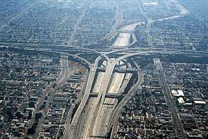
| R7.39 | 7B | I-110 south exit 14A, north exits 14A-B | |||
| | — | Two-lane left exit; left lane tolled, right lane free HOV access only | |||
| R8.90 | 9 | Central Avenue | |||
| Willowbrook | R9.78 | 10 | Wilmington Avenue | ||
| Lynwood | R11.51 | 12 | Long Beach Boulevard | ||
| R13.47 | 13 | I-710 north exit 11, south exit 11A | |||
| Paramount | R14.13 | 14 | Garfield Avenue | Eastbound exit and westbound entrance | |
| R14.65 | 15 | Paramount Boulevard | Westbound exit and eastbound entrance | ||
| Bellflower | R15.76 | 16 | |||
| Downey | R16.64 | 17 | Bellflower Boulevard | ||
| Norwalk | R17.82 | 18 | Signed as exits 18A (south) and 18B (north); I-605 exit 9B | ||
| R17.91 | — | Hoxie Avenue – Norwalk Metro Station | HOV exits only; all traffic allowed on westbound entrance; westbound entrance also includes direct entrance ramp from Imperial Highway | ||
| R18.15 | — | Studebaker Road | HOV only entrance, and exit from I-105; all traffic allowed on direct ramp from Hoxie Avenue; at-grade intersection | ||
| 1.000 mi = 1.609 km; 1.000 km = 0.621 mi | |||||
In popular culture
- The Judge Harry Pregerson Interchange with I-110 was used in the 2016 musical film La La Land
- Scenes for the 1994 film Speed were filmed on the freeway before it opened. The freeway was used for both a stand-in for Interstate 10 and as the still-unopened 105 freeway.
- The song "Rollin' with My Homies," by the rapper Coolio.
- In the 2013 video game Grand Theft Auto V, set in the fictional city of Los Santos (based on the Los Angeles metropolitan area), the 105 is represented as the Olympic Freeway.
- in the 2007 film Live Free Or Die Hard, the climatic scene where the protagonist John McClane is being chased by a fighter jet was filmed on the 105 freeway.
See also

References
- 1 2 California Department of Transportation (July 2007). "Log of Bridges on State Highways". Sacramento: California Department of Transportation.
- ↑ "SC Los Angeles-Orange County fun facts page". Scvresources.com. Archived from the original on November 15, 2011. Retrieved January 26, 2013.
- ↑ Jeanne Bonfilio Issue Date: 04/2008. "Inside Seven - Caltrans, District 7 - Monthly Newsletter". Dot.ca.gov. Retrieved January 26, 2013.
- ↑ "I-105 Glenn Anderson Freeway (Century Freeway)". Roadstothefuture.com. Retrieved January 26, 2013.
- ↑ "Road: Century Freeway Project". Art-poetry.info. Retrieved January 26, 2013.
- ↑ "The Finding Aid of the Century Freeway records 0228". Oac.cdlib.org. Retrieved January 26, 2013.
- ↑ California State Legislature. "Section 250–257". Streets and Highways Code. Sacramento: California State Legislature. Retrieved June 9, 2017.
- ↑ Federal Highway Administration (March 25, 2015). National Highway System: Los Angeles, CA (PDF) (Map). Scale not given. Washington, DC: Federal Highway Administration. Retrieved October 1, 2017.
- ↑ Natzke, Stefan; Neathery, Mike & Adderly, Kevin (June 20, 2012). "What is the National Highway System?". National Highway System. Washington, DC: Federal Highway Administration. Retrieved July 1, 2012.
- ↑ Faigin, Daniel P. "California Highways: Routes 105 through 112". California Highways: Routes 105 through 112. Retrieved 2015-01-07.
- ↑ "Photo Exhibit: Constructing Interstate 105". Craftypixel.com. Retrieved January 26, 2013.
- ↑ Henry Weinstein, "A Concrete Accomplishment : Transit: Long-planned Interstate 105 opens with gala festivities. Amid the tumult, Judge Harry Pregerson takes pride in job-training and housing programs he helped ensure in the freeway corridor." Los Angeles Times, October 15, 1993.
- ↑ Hertzberg. "ACR 142 Assembly Concurrent Resolution". Info.sen.ca.gov. Archived from the original on June 30, 2012. Retrieved January 26, 2013.
- ↑ Curtiss, Aaron (April 19, 1996). "The Freeway Numbers Game". Los Angeles Times. Retrieved 4 July 2016.
- ↑ "CA-Highways 105-112". Cahighways.org. Retrieved January 26, 2013.
- 1 2 California Department of Transportation. "State Truck Route List". Sacramento: California Department of Transportation. Archived from the original (XLS file) on June 30, 2015. Retrieved June 30, 2015.
- ↑ California Department of Transportation, All Traffic Volumes on CSHS, 2005 and 2006
- ↑ California Department of Transportation, California Numbered Exit Uniform System, I-105 Eastbound and I-105 Westbound, accessed February 2008
External links
| Wikimedia Commons has media related to Interstate 105 (California). |
Route map: