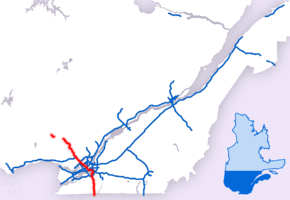
Quebec Autoroute 15
| ||||
|---|---|---|---|---|
|
Autoroute Décarie Autoroute des Laurentides | ||||
 | ||||
| Route information | ||||
| Maintained by Transports Québec | ||||
| Length | 164.0 km[1][2] (101.9 mi) | |||
| Existed | 1958 [2][3] – present | |||
| Major junctions | ||||
| South end |
| |||
|
| ||||
| North end |
| |||
| Location | ||||
| Major cities | La Prairie, Brossard, Montreal, Laval, Boisbriand, Blainville, Mirabel, Saint-Jérôme | |||
| Highway system | ||||
| ||||

Autoroute 15 (also called the Décarie Expressway (English) or Autoroute Décarie (French) between the Turcot and Décarie Interchanges in Montreal and the Laurentian Autoroute (English) or Autoroute des Laurentides (French) north of Autoroute 40) is a highway in western Quebec, Canada. It was, until the extension of Autoroute 25 was opened in 2011, the only constructed north-south autoroute to go out of Montreal on both sides. A-15 begins at the end of Interstate 87 at the United States border at Saint-Bernard-de-Lacolle and extends via Montreal to Sainte-Agathe-des-Monts with an eventual continuation beyond Mont-Tremblant. The total length of A-15 is currently 164 km (101.9 mi), including a short concurrency (4 km or 2.5 mi) with Autoroute 40 (Boulevard/Autoroute Métropolitan) that connects the two main sections. This is one of the few autoroutes in Quebec that does not have any spinoff highways.
Road description
Southern section
The southern section of A-15 connects the south shore suburbs of Montreal and is also the primary trade corridor route between Montreal and New York City linking Quebec Autoroute 15 to Interstate 87 at the Canada-United States border at the Champlain-St. Bernard de Lacolle Border Crossing. This was the former Route 9, and connected with US 9 on the western shore of Lake Champlain. In Brossard, it joins up with A-10 and A-20 across the Champlain Bridge into Montreal. The A-10 splits off almost immediately after crossing the bridge to head into downtown Montreal at the Bonaventure Expressway and the A-20 splits off shortly after at the Turcot Interchange (échangeur Turcot), leaving the A-15 to continue northward as Autoroute Décarie until the Décarie Interchange (échangeur Décarie) with the A-40 at the point where it turns from the Trans-Canada into the Metropolitan Expressway.
The route is also connected to Autoroute 30 in Candiac which was completed to Autoroute 20 in 2012 providing a quicker access to the south shore of Montreal, to southern communities located alongside Autoroute 15 and to the Canada–US border in Lacolle. It will also give a quicker access from there to areas west of Montreal and also Ottawa and Gatineau.
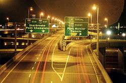
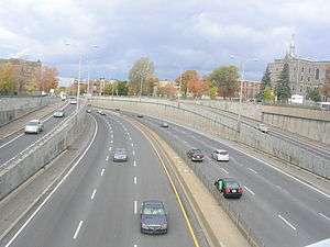
Décarie Autoroute
The Décarie Autoroute is a sunken highway between the northbound and southbound lanes of Decarie Boulevard from the Metropolitan Autoroute at its northern end to Monkland Avenue and the Villa Maria Metro station at its southern end. It was built on a wide expanse of vacant land, donated to the city by the Décarie estate on the condition that only a streetcar line be established. The decommissioning of the streetcar system in 1959 left the right-of-way as an obvious choice for a highway, and so the Décarie Autoroute was dug there. South of Queen Mary Road, however, were a significant number of houses that were demolished. In order to avoid demolishing the Notre-Dame-de-Grâce church, the highway makes a slight westerly jog below Côte-Saint-Luc Road and runs through a short tunnel, before emerging between Addington and Botrel Streets and running down to Sherbrooke Street and Saint Jacques Street, where it spectacularly goes from below-ground to well above ground as it intersects with Autoroutes 20 and 720 in the infamous Turcot Interchange (dubbed "Spaghetti Junction" by train crews operating the former CN Rail Turcot Yard). Following the conversion from streetcar line to highway, the Décarie Estate unsuccessfully sued the city but was unable to prevail because they did not document their case well enough for the nevertheless sympathetic court.
Decarie Boulevard
Decarie Boulevard itself continues; from Monkland Avenue south to Saint Jacques Street past the McGill University Health Centre Glen Campus superhospital; and from Autoroute 40 north into Ville Saint-Laurent past Du College Station and Côte-Vertu Station/Norgate shopping centre to Poirier Street. Between Monkland Avenue and A 40, Decarie Boulevard serves as sort of a service road on both sides of the autoroute.
Northern section
After its concurrency with A-40, the northern section of A-15 is the main freeway route to the Laurentians, or Laurentides, until it downgrades to Route 117. It also links up to the northern suburbs of Montreal, as well as provides a connection to the A-440, A-640 and the A-50 in Mirabel. The first section from A-40 to Saint-Jérôme was opened in 1958 as a toll road, although the tolls were removed in 1985. This section was also the first to be designed as an autoroute in the province. It was named Autoroute Montréal-Laurentides during the 1960s.[4]
Over the next years, it was extended north to Sainte-Agathe-des-Monts as a new connection to touristic and skiing destinations in the Laurentides including in Saint-Sauveur, Sainte-Adèle, Mont-Gabriel and Estérel. In the future, it is possible that the A-15 may continue even farther north, past Mont-Tremblant, as Route 117 is already an at-grade expressway with a freeway bypass of Saint-Jovite completed, and the name Autoroute des Laurentides is also recognized on the freeway bypass (and exit numbers continue). This section is numbered separately from the southern section as if it were a different route. The northern route is also part of the Trans-Canada Highway.
Exit list
Exit numbering resets at the two interchanges with Autoroute 40 in Montréal.
| Region | Location | km | mi | Exit | Destinations | Notes | |
|---|---|---|---|---|---|---|---|
| Continues as | |||||||
| Montérégie | Saint-Bernard-de-Lacolle | 0.00 | 0.00 | Canada–United States border Champlain–St. Bernard de Lacolle Border Crossing | |||
| 1 | Montée Glass / Montée Guay | Also signed as a u-turn | |||||
| 6 | |||||||
| 11 | Montée Henrysburg | ||||||
| 13 | Montée Murray | Southbound exit only | |||||
| Saint-Patrice-de-Sherrington– Saint-Jacques-le-Mineur | 21 | Also serves Route 217 | |||||
| Saint-Édouard | 29 | Saint-Édouard, Saint-Jacques-le-Mineur | Via Montée du Moulin | ||||
| Saint-Mathieu | 38 | Saint-Mathieu, Saint-Philippe | Via Montée Monette | ||||
| Candiac | 40 | Exit 55 on A-30; opened December 2010 | |||||
| 42 | Southern terminus of concurrency with Route 132; shared ramp with exit 40 northbound | ||||||
| 44 | Boulevard Montcalm – Candiac | ||||||
| 45 | Northbound exit and southbound entrance; south end of Route 134 | ||||||
| La Prairie | 46 | Boulevard Salaberry – La Prairie | |||||
| 47 | Rue Saint-Henri – La Prairie | Northbound exit and entrance | |||||
| 49 | Rue du Quai | Southbound exit and entrance; to Parc de la Marina | |||||
| Brossard | 50 | Boulevard Matte | |||||
| 51 | Boulevard Rivard | Southbound exit is via exit 50 | |||||
| Rue Riviera | Southbound exit and entrance | ||||||
| 52 | Boulevard Rome | ||||||
| 53 | A-15 branches west; northern terminus of concurrency with Route 132; southern terminus of concurrency with A-10 and A-20; exit 6 on A-10 | ||||||
| St. Lawrence River | Pont Champlain | ||||||
| Montreal | Montreal | 57 | Île de Sœurs | Northbound exit and entrance | |||
| 57N | Chemin de la Pointe-Nord Road | Southbound exit and entrance | |||||
| 57S | Boulevard de l'Île des Soeurs | Southbound exit and entrance | |||||
| 58 | Northern terminus of concurrency with A-10; signed as exit 57O (west) southbound | ||||||
| 60 | Northbound access to A-10 is via exit 58; exit 4 on A-10 | ||||||
| 61 | Rue Saint Patrick / Avenue Atwater | ||||||
| 62 | Boulevard de La Vérendrye / Avenue de l'Église | ||||||
| 63 | Turcot Interchange Northern terminus of concurrency with A-20; signed as exits 63E (east) and 63O (west) southbound; A-20 exit 68; A-720 exit 1 | ||||||
| Southern terminus of Autoroute Décarie | |||||||
| 64 | |||||||
| 66 | Chemin Côte-Saint-Luc / Chemin Queen-Mary / Chemin de la Côte-Sainte-Catherine | ||||||
| 69 | Rue Jean-Talon / Rue de la Savane / Avenue Van Horne / Chemin de la Côte-Sainte-Catherine | ||||||
| 70 66[lower-roman 1] | Décarie Interchange A-15 branches east; southern terminus of concurrency with of A-40 | ||||||
| Northbound exit, southbound entrance | |||||||
| Northern terminus of Autoroute Décarie | |||||||
| 68[lower-roman 1] | Rue Stinson / Chemin Rockland / Boulevard de L'Acadie | Northbound exit and southbound entrance | |||||
| 70[lower-roman 1] 1 | A-15 branches north; northern terminus of concurrency with A-40 | ||||||
| Southbound exit | |||||||
| Southern terminus of | |||||||
| 2 | Boulevard de la Côte-Vertu – Saint-Laurent | Southbound exit and northbound entrance | |||||
| Rue Sauvé / Boulevard Henri-Bourassa / Boulevard de L'Acadie | Northbound exit and entrance | ||||||
| 3 | Boulevard Henri-Bourassa | Northbound exit is via exit 3 | |||||
| 4 | Rue de Salaberry | Signed as exits 4E (east) and 4O (west) southbound; no southbound entrance | |||||
| Rivière des Prairies | Pont Médéric-Martin | ||||||
| Laval | 7 | Boulevard Cartier / Boulevard de la Concorde / Boulevard Notre-Dame | Northbound entrance and exit via Le Corbusier Boulevard | ||||
| 8 | Boulevard Saint-Martin | Southbound exit is via exit 10 | |||||
| 10 | Exit 22 on A-440 | ||||||
| 14 | Signed as exits 14N (north) and 14S (south) southbound | ||||||
| 16 | Boulevard Sainte-Rose / Avenue de la Renaissance | ||||||
| Rivière des Mille Îles | Gedeon Ouimet Bridge | ||||||
| Laurentides | Boisbriand | 19 | |||||
| Boisbriand– Sainte-Thérèse | 20 | Signed as exits 20E (east) and 20O (west); exit 20 on A-640 | |||||
| 23 | Rue Saint-Charles – Saint-Augustin Centre-Ville Sainte-Thérèse | ||||||
| Blainville | 25 | Boulevard de la Seigneurie – Blainville | |||||
| Mirabel–Blainville | 28 | Boulevard Michèle-Bohec / Chemin Notre-Dame – Mirabel, Blainville | |||||
| Mirabel | 31 | Saint-Janvier, Sainte-Monique | Via Rue Charles | ||||
| 35 | Exit 282 on A-50 | ||||||
| 39 | |||||||
| Saint-Jérôme | 41 | Boulevard du Grand-Héron | |||||
| 43 | Rue De Martigny Ouest – Centre-Ville Saint-Jérôme, Saint-Colomban, Mille-Isles | Signed as exits 43E (east) and 43O (west) | |||||
| 45 | No direct southbound access to Routes 117 and 333 | ||||||
| 51 | Aire de Service La Porte du Nord (service centre) | ||||||
| Prévost | 55 | Prévost | Northbound exit and southbound entrance | ||||
| Sainte-Anne-des-Lacs | 57 | No southbound exit | |||||
| 58 | Chemin Avila – Piedmont | ||||||
| Saint-Sauveur | 60 | ||||||
| Sainte-Adèle | 64 | Chemin du Mont-Gabriel | |||||
| 67 | Northbound exit and southbound entrance | ||||||
| 69 | |||||||
| 72 | Chemin du Mont-Sauvage / Montée à Séraphin – Sainte-Adèle | Northbound exit and southbound entrance | |||||
| Val-Morin | 76 | Northbound exit and southbound entrance | |||||
| Val-David | 80 | Val-David, 7e Rang | Northbound exit and southbound entrance | ||||
| Sainte-Agathe-des-Monts | 83 | Northbound exit and southbound entrance | |||||
| 86 | |||||||
| 88 | Rue Demontigny | Northbound exit and southbound entrance | |||||
| 89 | Northbound exit and southbound entrance | ||||||
| – | Trans-Canada Highway follows Route 117 north | ||||||
1.000 mi = 1.609 km; 1.000 km = 0.621 mi
| |||||||
Disasters
On June 18, 2000, the southern portion of the Boulevard du Souvenir overpass in Laval (which crosses over Quebec Autoroute 15), under reconstruction, collapsed into the roadway, killing one and injuring two when cars were crushed underneath the structure. Sixteen beams weighing about 70 tonnes (69 long tons; 77 short tons) each fell. The contractor was faulted for shoddy work. The arched concrete beams were unsecured and tipped over like dominoes, many of them breaking into pieces.
The expressway has also seen flooding. On July 14, 1987, a sudden torrential downpour caused by an HP supercell thunderstorm dumped over 100 millimetres (3.9 inches) of rain in just over one hour across the city. The Décarie Expressway, which is below-grade, was heavily flooded and became a river. At some locations, the water reached a maximum of 3.6 metres (12 feet) in depth on the roadway. Over 300 vehicles were abandoned when they were submerged. Two people were killed by the storm.[5] One 80-year-old man on the Expressway drowned and another one was killed by electrical wires (electrocuted). On July 5, 2005, another torrential downpour flooded portions of the Expressway after several manhole covers blew open from the storm sewers below them being overloaded.[6]
See also
Notes
References
- ↑ Ministère des transports, "Distances routières", page (?), Les Publications du Québec, 2005
- 1 2 "Répertoire des autoroutes du Québec" (in French). Transports Québec. Archived from the original on 2010-01-11. Retrieved 2008-02-23.
- ↑ 1958 Archived 2006-04-27 at the Wayback Machine.
- ↑ Autoroute Montréal-Laurentides Archived 2006-04-27 at the Wayback Machine.
- ↑ Environment Canada - Water - Main page Archived 2007-01-25 at the Wayback Machine.
- ↑ Canoe – Infos – Québec-Canada: 30 millimètres d’eau en deux minutes sur l’autoroute Décarie
External links
Route map:
| Wikimedia Commons has media related to Quebec Autoroute 15. |
- A-15 at Exitlists.com
- A-15 at Quebec Autoroutes
- Steve Anderson's MontrealRoads.com: Decarie Autoroute (A-15)
- Steve Anderson's MontrealRoads.com: Laurentian Autoroute (A-15)
- Transports Quebec Map
| Wikinews has related news: Highway overpass collapses near Montreal |
| Preceded by |
Trans-Canada Highway |
Succeeded by |
| British Columbia | ||
|---|---|---|
| Alberta | ||
| Saskatchewan | ||
| Manitoba | ||
| Ontario | ||
| Quebec | ||
| New Brunswick | ||
| Prince Edward Island | ||
| Nova Scotia | ||
| Newfoundland | ||
| ||