Saint-Sauveur, Quebec
| Saint-Sauveur | |
|---|---|
| City | |
 | |
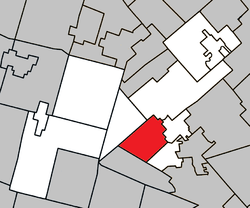 Location within Les Pays-d'en-Haut RCM | |
 St-Sauveur Location in central Quebec | |
| Coordinates: 45°54′N 74°10′W / 45.9°N 74.17°WCoordinates: 45°54′N 74°10′W / 45.9°N 74.17°W[1] | |
| Country |
|
| Province |
|
| Region | Laurentides |
| RCM | Les Pays-d'en-Haut |
| Constituted | September 11, 2002 |
| Government[2] | |
| • Mayor | Jacques Gariépy |
| • Federal riding | Laurentides—Labelle |
| • Prov. riding | Bertrand |
| Area[2][3] | |
| • Total | 50.20 km2 (19.38 sq mi) |
| • Land | 47.79 km2 (18.45 sq mi) |
| Population (2011)[3] | |
| • Total | 9,881 |
| • Density | 206.8/km2 (536/sq mi) |
| • Pop (2006–11) |
|
| Time zone | UTC−5 (EST) |
| • Summer (DST) | UTC−4 (EDT) |
| Postal code(s) | J0R |
| Area code(s) | 450 and 579 |
| Website |
www |
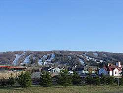
Saint-Sauveur (French pronunciation: [sɛ̃ sovœʁ]) is a town and municipality within the Les Pays-d'en-Haut Regional County Municipality, Quebec, Canada. It is in the administrative region of Laurentides in the Laurentian mountains, located about 60 kilometres north of Montreal.
St-Sauveur is well known for its local ski areas, the biggest of which is Mont Saint-Sauveur. The ski areas market themselves jointly under the name of "Valley of Saint-Sauveur". Its proximity to Montreal, as well as its snow-making capability, night-time skiing, and après-ski establishments make St-Sauveur a popular destination for skiers.
The town was the childhood home—from about 1946 to 1960—of Canadian musicians Kate and Anna McGarrigle.
On September 11, 2002 the city was created from the merger of the village of Saint-Sauveur-des-Monts and the parish municipality of Saint-Sauveur.[4] The current director general is Jean Beaulieu. The city clerk is Normand Patrice.
Demographics
Population trend:[5]
- Population in 2011: 9881 (2006 to 2011 population change: 7.5%)
- Population in 2006: 9191 (2001 to 2006 population change: 13.2%)
- Population in 2001: 8122
- Saint-Sauveur (Parish): 4806
- Saint-Sauveur-des-Monts (Village): 3316
- Population in 1996:
- Saint-Sauveur (Parish): 3970
- Saint-Sauveur-des-Monts (Village): 2904
- Population in 1991:
- Saint-Sauveur (Parish): 2719
- Saint-Sauveur-des-Monts (Village): 2545
Private dwellings occupied by usual residents: 4886 (total dwellings: 6636)
Mother tongue:[6]
- English as first language: 9%
- French as first language: 86%
- English and French as first language: 1%
- Other as first language: 3%
Education
Sir Wilfrid Laurier School Board operates Anglophone public schools:
- Morin Heights Elementary School in Morin-Heights[7]
- Laurentian Regional High School in Lachute[8]
Images
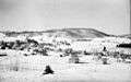 Saint-Sauveur-des-Monts in 1942
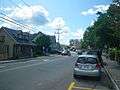 Rue Principale
.JPG) Saint-Sauveur Village
Saint-Sauveur Village Church in Saint-Sauveur
See also
References
- ↑ Reference number 377892 of the Commission de toponymie du Québec (in French)
- 1 2 "Saint-Sauveur". Répertoire des municipalités (in French). Ministère des Affaires municipales, des Régions et de l'Occupation du territoire. Archived from the original on 2012-05-01. Retrieved 2011-06-22.
- 1 2 Statistics Canada Census, 2011 Census Profiles: Saint-Sauveur
- ↑ http://www.stat.gouv.qc.ca/publications/referenc/pdf/modsept02.pdf%5Bpermanent+dead+link%5D
- ↑ Statistics Canada: 1996, 2001, 2006, 2011 census
- ↑ Statistics Canada Census, 2006 Community Profiles: Saint-Sauveur
- ↑ "MORIN HEIGHTS ELEMENTARY ZONE." Sir Wilfrid Laurier School Board. Retrieved on September 16, 2017.
- ↑ "LAURENTIAN REGIONAL HS ZONE." Sir Wilfrid Laurier School Board. Retrieved on September 4, 2017.
External links
| Wikimedia Commons has media related to Saint-Sauveur, Quebec. |
- City of Saint-Sauveur website
- Valley of Saint-Sauveur Ski Resorts
- Saint-Sauveur business and tourism
- Directory of lodging, restaurants and activities
- Photo Gallery Saint-Sauveur, Quebec, Canada
- Forum Directory and News for Saint-Sauveur, Quebec, Canada
Places adjacent to Saint-Sauveur, Quebec | ||||||||||
|---|---|---|---|---|---|---|---|---|---|---|
| ||||||||||
| Towns | |
|---|---|
| Municipalities | |
| Parishes | |
| |