Piedmont, Quebec
| Piedmont | |
|---|---|
| Municipality | |
 | |
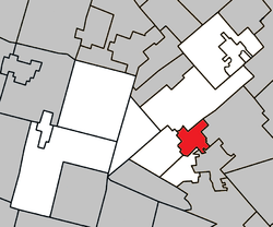 Location within Les Pays-d'en-Haut RCM | |
 Piedmont Location in central Quebec | |
| Coordinates: 45°54′N 74°08′W / 45.9°N 74.13°WCoordinates: 45°54′N 74°08′W / 45.9°N 74.13°W[1] | |
| Country |
|
| Province |
|
| Region | Laurentides |
| RCM | Les Pays-d'en-Haut |
| Constituted | September 22, 1923 |
| Government[2] | |
| • Mayor | Clément Cardin |
| • Federal riding | Laurentides—Labelle |
| • Prov. riding | Bertrand |
| Area[2][3] | |
| • Total | 24.70 km2 (9.54 sq mi) |
| • Land | 24.37 km2 (9.41 sq mi) |
| Population (2011)[3] | |
| • Total | 2,721 |
| • Density | 111.7/km2 (289/sq mi) |
| • Pop (2006–11) |
|
| Time zone | UTC−5 (EST) |
| • Summer (DST) | UTC−4 (EDT) |
| Postal code(s) | J0R 1K0 |
| Area code(s) | 450 and 579 |
| Website |
www |
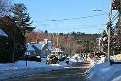
Piedmont is a small municipality within the Les Pays-d'en-Haut Regional County Municipality, Quebec, Canada, in the Laurentian Mountains of the administrative region of Laurentides. It is located along the North River and Autoroute 15 and Route 117, north of Montreal.
Police services are provided by the Régie intermunicipale de police de la Rivière-du-Nord, which also serves Prévost and some other nearby communities in the Laurentians.
Demographics
Population trend:[4]
- Population in 2011: 2721 (2006 to 2011 population change: 14.0%)
- Population in 2006: 2386
- 2001 to 2006 population change: 12.4%
- Population in 2001: 2122
- Population in 1996: 1862
- Population in 1991: 1462
Private dwellings occupied by usual residents: 1397 (total dwellings: 1996)
Mother tongue:
- English as first language: 8%
- French as first language: 90.5%
- English and French as first language: 0.5%
- Other as first language: 1%
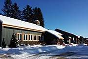 Piedmont town hall
.JPG) Rivière du Nord in Piedmont
Rivière du Nord in Piedmont
Education
Sir Wilfrid Laurier School Board operates Anglophone public schools:
- Morin Heights Elementary School (serves a portion) in Morin-Heights[5]
- Saint Adèle Elementary School (serves a portion) in Saint-Adèle[6]
See also
References
- ↑ Reference number 48955 of the Commission de toponymie du Québec (in French)
- 1 2 Geographic code 77030 in the official Répertoire des municipalités (in French)
- 1 2 "(Code 2477030) Census Profile". 2011 census. Statistics Canada. 2012.
- ↑ Statistics Canada: 1996, 2001, 2006, 2011 census
- ↑ "MORIN HEIGHTS ELEMENTARY ZONE." Sir Wilfrid Laurier School Board. Retrieved on September 16, 2017.
- ↑ "maps zone/171 - WEB SAINTE ADELE.pdf SAINTE ADÈLE ELEMENTARY ZONE." Sir Wilfrid Laurier School Board. Retrieved on September 16, 2017.
External links
| Wikimedia Commons has media related to Piedmont, Quebec. |
- Site officiel Piedmont
- Tourisme Pays-d'en-Haut
- Piedmont at Commission de toponymie du Québec
- Statistics Canada
Places adjacent to Piedmont, Quebec | |
|---|---|
| Towns | |
|---|---|
| Municipalities | |
| Parishes | |
| |
This article is issued from
Wikipedia.
The text is licensed under Creative Commons - Attribution - Sharealike.
Additional terms may apply for the media files.