Autoroutes of Quebec
| Autoroutes of Quebec | |
|---|---|
   Highway shields for Autoroutes 5, 85 and 410 | |
 The current Autoroute network in Quebec | |
| System information | |
| Maintained by Transports Quebec (MTQ) | |
| Length | 2,381.9 km[1][2] (1,480.0 mi) |
| Formed | 1958 |
| System links | |
| Quebec provincial highways | |

The autoroute system is a network of freeways within the province of Quebec, Canada, operating under the same principle of controlled access as the Interstate Highway System in the United States and the 400-series highways in neighbouring Ontario. The Autoroutes are the backbone of Quebec's highway system, spanning almost 2,400 km (1,491 mi). The speed limit on the Autoroutes is generally 100 km/h (62 mph) in rural areas and 70–90 km/h (43–56 mph) in urban areas; most roads are made of asphalt concrete.
The word autoroute is a portmanteau of auto and route, equivalent to "motorway" in English, and has become the Quebec French equivalent of "expressway". In the 1950s, when the first Autoroutes were being planned, the design documents called them autostrades, from the Italian word autostrada.[3]
Signage
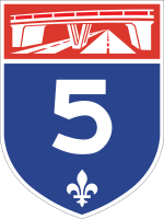
Autoroutes are identified by blue-and-red shields, similar to the American Interstate system. The red header of the shield contains a white image representing a highway overpass, and the blue lower portion of the shield contains the Autoroute's number in white, along with a fleur-de-lis, which is a provincial symbol of Quebec.
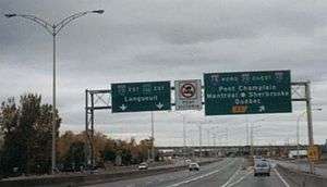
Most Autoroute and road traffic signs in the province are in French, though English is also used on federally-financed or -owned routes, such as the Bonaventure Expressway in Montreal. To surmount the language barrier, however, most signs in Quebec use pictograms and text is avoided in most cases, with the exceptions usually only being the names of control cities. Other exceptions that are posted in both languages is the illegal use of radar detectors when entering the province that reads "DÉTECTEURS DE RADAR INTERDITS/RADAR DETECTORS PROHIBITED", as well as areas where roads can be slippery due to melting ice and snow, marked "DEGEL/THAW".
Numbering system
Autoroutes are divided into three types – principal routes, deviation routes, and collector routes – and are laid out and numbered in a fashion similar to the Interstate Highway System in the United States. The principal Autoroutes are the major highways of the province, and have single- or double-digit numbers. East-west Autoroutes running parallel to the Saint Lawrence River (for example, Autoroute 20 and Autoroute 40) are assigned even numbers, while north-south Autoroutes running perpendicular to the Saint Lawrence (such as Autoroute 5 and Autoroute 15) are given odd numbers. Deviation and collector Autoroutes both feature triple-digit numbers. Deviation routes are bypasses intended for truck traffic to circumvent urban areas, and are identified by an even number prefixing the number of the nearby Autoroute that it bypasses (for example, Autoroute 440 in Laval). Collector Autoroutes, by contrast, are spur routes into urban areas, and are identified by an odd number prefixing the number of the nearby Autoroute that it branches off of (such as Autoroute 720, a spur of Autoroute 20 into downtown Montreal).
History
Quebec's first Autoroute was the Autoroute des Laurentides (Laurentian Autoroute), which opened in 1959 as a toll road. This initiative to bring freeways into Quebec was started by Maurice Duplessis, whose government saw the construction of the Laurentian Autoroute (now A-15) from Montreal to Saint-Jérôme and the first section of the Boulevard Métropolitain (A-40), which opened in 1960.
1960s
It was the Quebec Liberal government of the 1960s that saw the construction of further Autoroutes, with a grid numbering system and the introduction of the blue and red shield. The sign is inspired by the American Interstate sign. This was especially needed in light of the fact that many visitors would be flocking to Montreal by car for Expo 67. Montreal's Autoroute Décarie (A-15) and the Louis-Hippolyte Lafontaine Bridge–Tunnel were constructed for that very reason. The Autoroute des Cantons-de-l'Est (Eastern Townships Autoroute - A-10) opened in 1964, and its continuation, A-55 between Magog and Rock Island, opened in 1967, connecting with Interstate 91. What are now the A-20 (part of the Trans-Canada Highway) and the A-15 to New York (connecting with Interstate 87), originally built in the 1940s, were upgraded to expressway standards. The A-20 also connects with Highway 401 in Ontario. A-40 was extended out to Berthierville, and later to Trois-Rivières in the 1970s. Others include Autoroutes 25, 30 (southern beltway), 31, 35 (eventually connecting to Interstate 89), Autoroute Laurentienne (73), and 640 (an unfinished proposed northern beltway).
1970s
The 1970s also saw the completion of the Pierre Laporte Bridge in Quebec City, connecting the south shore of the Saint Lawrence River to the north. In addition to this, the A-73 was extended to Beauce, the A-20 was extended to Rivière-du-Loup, and the Chomedey Autoroute (A-13), the A-19 and the A-440 were constructed in Laval. Autoroutes were built (two sections of A-440, and A-740) and a few more planned in the Quebec City region, creating a dense web, which led to significant sprawl. In 1976, the Parti Québécois came to power, whose platform mandated an expansion of public transportation over the construction of more Autoroutes. Existing Autoroutes were extended (e.g., the A-40 was extended from Trois-Rivières to Quebec City) but no new Autoroutes were built.
The Autoroute des Laurentides, the Autoroute des Cantons-de-l'Est, the Autoroute de la Rive-Nord (North Shore Autoroute), and the A-13 were toll roads until the mid-1980s, when the toll barriers were removed and the province stopped collecting tolls from vehicles using the Autoroutes. The last toll booth was on the Champlain Bridge (A-10,A-15 and A-20). It was removed in 1990 because the Champlain Bridge is federal property and is thus not subject to provincial tolls.
2000s
In the 2000s, there were several high-profile failures and collapses around some Autoroutes, due to aging and crumbling infrastructure, including the Boulevard du Souvenir overpass collapse, De la Concorde overpass collapse, and most recently the Ville-Marie tunnel collapse. An online poll by Léger Marketing conducted shortly after the Viger tunnel collapse found that 88 percent of Montrealers are "worried" about the state of roads, bridges and tunnels in the city, with more than half of respondents saying they are downright "scared" to drive under an overpass (58 percent), on a bridge (54 per cent), or through a tunnel (53 per cent). McGill University's Saeed Mirza stated that ill-advised design choices and poor-quality concrete were used in the construction rush ahead of Expo '67 and the 1976 Olympics. In particular, the concrete used was permeable with lack of proper drainage, and these allowed chlorides from de-icing salts to corrode the steel reinforcements.[4]
Main-class autoroutes
| Number | Length (km)[2][1] | Length (mi) | Southern or western terminus | Northern or eastern terminus | Local names | Formed[2] | Removed | Notes |
|---|---|---|---|---|---|---|---|---|
| 34.0 | 21.1 | Ontario boundary in Gatineau (Continues as King Edward Avenue in Ottawa) | Route 105 / Route 366 in Wakefield | Autoroute de la Gatineau | 1964 | current | ||
| 55 | 34 | A-15 in La Prairie | Route 235 in Farnham | Richelieu Autoroute, Autoroute Haut-Richelieu | — | — | A-6 was to roughly parallel Route 104. The western half of the route was cancelled by the mid-1970s while the rest of the route was abandoned a few years later. | |
| 12 | 7 | A-40 in Pointe-Fortune | A-50 in Lachute | Pointe Fortune-Lachute Autoroute | — | — | A-9 was to provide a fixed crossing over the Ottawa River but was cancelled. | |
| 145.1[5] | 90.2 | A-720 in Montreal | A-55 / A-610 in Sherbrooke | Autoroute Bonaventure, Autoroute des Cantons-de-l'Est | 1962 | current | ||
| 21.4 | 13.3 | A-20 in Lachine | A-640 in Boisbriand | Autoroute Chomedey | 1975 | current | ||
| 164.0 | 101.9 | United States border at Lacolle (continues as I-87) | Route 117 / Route 329 in Sainte-Agathe-des-Monts | Autoroute Décarie, Autoroute des Laurentides | 1958 | current | Part of the Trans-Canada Highway between A-40 in Montreal and Sainte-Agathe-des-Monts. | |
| 9 | 6 | A-30 in Longueuil | Jacques Cartier Bridge | Autoroute Wilfrid-Laurier | — | — | Reserved for autoroute conversion of Boulevard Wilfrid-Laurier (Route 112 and Route 116). | |
| — | — | A-55 near Victoriaville | Proposed A-65 in Plessisville | Autoroute des Bois-Francs | — | — | Unbuilt. | |
| 10.1 | 6.3 | A-40 in Montreal | A-440 / Route 335 in Laval | Autoroute Papineau | 1970 | current | ||
| 534.5 | 332.1 | Ontario border at Rivière-Beaudette (continues as Highway 401) | Route 132 in Notre-Dame-des-Neiges | Autoroute Jean-Lesage, Autoroute du Souvenir | 1964 | current | Part of the Trans-Canada Highway between A-25 in Longueuil and A-85 in Rivière-du-Loup. | |
| 45.2 | 28.1 | Route 132 in Rimouski | Route 132 in Mont-Joli | Autoroute Jean-Lesage | 1991 | current | Future plans to connect to the western segment. | |
| 52.1 | 32.4 | A-20 in Longueuil | Route 125 / Route 158 in Saint-Esprit | Autoroute Transcanadienne, Autoroute Louis-Hippolyte-La Fontaine | 1967 | current | Part of the Trans-Canada Highway between A-40 in Montreal and A-20 in Longueuil. | |
| 144.1 | 89.5 | A-40 in Vaudreuil-Dorion | Route 132 in Sorel-Tracy | Autoroute de l'Acier | 1968 | current | ||
| 20.8 | 12.9 | A-55 / Route 132 in Bécancour | Route 132 in Bécancour | Autoroute de l'Acier | 1975 | current | No plans to connect to the western segment. | |
| 14.3 | 8.9 | A-40 in Lavaltrie | Route 158 in Joliette | Autoroute Antonio-Barrette | 1966 | current | ||
| 41.4 | 25.7 | Route 133 in Saint-Sébastien | A-10 in Chambly | Autoroute de la Vallée-des-Forts | 1966 | current | Future extension to United States border and I-89. | |
| 347 | 216 | Ontario border near Pointe-Fortune (continues as Highway 417) | Route 138 / Route 368 near Boischatel | Autoroute Félix-Leclerc, Autoroute Métropolitaine | 1959 | current | Part of the Trans-Canada Highway between Ontario and A-25 in Montreal. | |
| 159 | 99 | Route 148 in Gatineau | A-15 / Route 117 near Mirabel | Autoroute de l'Outaouais, Autoroute Maurice-Richard | 1975 | current | ||
| 45 | 28 | Route 116 near Melbourne | A-20 in Drummondville | 1974 | 1982 | Replaced by A-55. | ||
| 247 | 153 | United States border at Stanstead (continues as I-91) | Route 155 in Shawinigan | Autoroute Joseph-Armand-Bombardier, Autoroute de l'énergie | 1964 | current | ||
| — | — | Thetford Mines | A-20 in Villeroy | Autoroute de l'Amiante | — | — | Unbuilt. Possible extension to A-10 near Lambton. | |
| 24.2 | 15.0 | Route 170 in Saguenay (Jonquière) | Route 170 in Saguenay (Chicoutimi) | Autoroute du Saguenay, Autoroute Alma-La Baie | 1983 | current | Autoroute 70 is being extended from Jonquière to Alma, and eastward from Chicoutimi to La Baie. | |
| 135.0 | 83.9 | Route 204 in Saint-Georges | Route 175 in Stoneham-et-Tewkesbury | Autoroute Robert-Cliche, Autoroute Laurentienne, Autoroute Henri-IV | 1963 | current | ||
| 62.9 | 39.1 | New Brunswick border near Dégelis (continues as Route 2) | A-20 near Rivière-du-Loup | Autoroute Claude-Béchard | 2005 | current | Part of the Trans-Canada Highway for its full length. Presently a 35 km (22 mi) gap between Saint-Antonin and Saint-Louis-du-Ha! Ha!; connection made via Route 185, which it will eventually replace. | |
| ||||||||
Spur Class Autoroutes
| Number | Length (km)[2][1] | Length (mi) | Southern or western terminus | Northern or eastern terminus | Local names | Formed[2] | Removed | Notes |
|---|---|---|---|---|---|---|---|---|
| 12.9 | 8.0 | Route 108 / Route 143 in Sherbrooke | A-10 / A-55 in Sherbrooke | Autoroute Jacques-O'Bready, Autoroute de l'Université | 1971 | current | ||
| 7 | 4 | A-15 in Montréal | A-19 (unbuilt section) in Montreal | Mount Royal Autoroute | — | — | Cancelled northern leg of a proposed downtown freeway loop. | |
| — | — | A-15 / A-30 in Candiac | A-30 in Varennes | — | — | Several kilometers of Route 132 north and south of A-20 was designated A-430 on paper in the 1970s. | ||
| 18.2 | 11.3 | A-13 in Laval | A-25 in Laval | Autoroute Jean-Noël-Lavoie, Autoroute Laval | 1974 | current | ||
| 12.5 | 7.8 | A-40 / A-73 in Québec | A-40 in Québec | Autoroute Charest, Autoroute Dufferin-Montmorency | 1962 | current | Two segments with a 4 km (2.5 mi) gap through downtown Quebec City; connection made via Boulevard Charest. | |
| 7.8 | 4.8 | A-20 in Dorval | A-40 in Montréal | Autoroute Côte de Liesse | 1966 | current | ||
| 12.9 | 8.0 | Route 132 in Salaberry-de-Valleyfield | A-30 in Salaberry-de-Valleyfield | 2012 | current | Formerly part of A-30. | ||
| 5.1 | 3.2 | A-73 / Route 175 in Québec | A-40 in Québec | Autoroute Duplessis | 1966 | current | ||
| 4.9 | 3.0 | A-20 in Vaudreuil-Dorion | A-40 in Vaudreuil-Dorion | 1967 | 2012 | Replace by A-30. | ||
| — | — | Ontario boundary in Gatineau (Would continue as Highway 416 in Ottawa) | A-50 in Gatineau | Deschênes Autoroute, Britannia-Deschênes corridor | — | — | Gatineau bypass, including a new bridge across the Ottawa River. | |
| 12.9 | 8.0 | A-73 / A-40 in Québec | Route 369 in Québec | Autoroute Henri-IV | 1976 | current | ||
| 10.3 | 6.4 | A-10 / A-55 in Sherbrooke | Route 112 in Sherbrooke | Autoroute Louis-Bilodeau | 2006 | current | Formerly part of A-10. | |
| 53.2 | 33.1 | Route 344 in Oka | A-40 / Route 344 in Charlemagne | Autoroute de contournement nord de Montréal | 1961 | current | ||
| 8.1 | 5.0 | A-15 / A-20 in Montréal | Rue Notre-Dame in Montréal | Autoroute Ville-Marie | 1972 | current | ||
| 4.2 | 2.6 | A-30 in Saint-Constant | Route 132 in Saint-Constant | 2012 | current | Formerly part of A-30. | ||
| 7.4 | 4.6 | Route 175 in Quebéc | Boulevard Lebourgneuf in Québec | Autoroute Robert-Bourassa, Autoroute du Vallon | 1975 | current | ||
| 10 | 6 | A-55 in Trois-Rivières | A-40 in Trois-Rivières | Autoroute de Francheville | 1977 | c. 1980s | Replaced by A-40. | |
| 2.5 | 1.6 | A-30 in Candiac | Route 132 in Candiac | 2012 | current | Formerly part of A-30. | ||
| 15.9 | 9.9 | Rue Principale in Saint-Albert | A-20 / A-55 in Sainte-Eulalie | 1975 | current | None of this highway is of freeway standard. | ||
| 3.6 | 2.2 | Rue du Chalutier / Rue du Prince-Édouard in Quebéc | A-40 / A-73 in Quebéc | 1983 | current | Cosigned with Route 175 for its entire length. | ||
| ||||||||
See also
- Freeway (Canada)
- Highway
- List of Quebec provincial highways
- List of unbuilt autoroutes of Quebec
- Toll road
- Transports Québec
- 100-Series Highways (Nova Scotia) (not to be confused with Quebec's highway system that sets itself apart from the Autoroutes)
- 400-Series Highways (Ontario)
- 400-Series Highways (British Columbia) (former series)
References
- 1 2 3 Ministère des Transport: "Distances routières", page 5, Les Publication du Québec, 2005
- 1 2 3 4 5 "Répertoire des autoroutes du Québec" (in French). Transports Québec. Retrieved 2017-06-02.
- ↑
- In 1900 the word autostrade was used in Aéroport intercontinental. Bassin d'Arcachon. Le Teich Editor: J. Bière (Bordeaux) gallica.bnf.fr/ark:/12148/bpt6k96147718/f15.image
- In 1924, the Italian word autostrada was coined (See www.cnrtl.fr/definition/autostrade )
- In 1924, the words auto-strade and auto-route were used in the French language in Revue d'artillerie (Nancy, Paris, etc.) 1924-01 gallica.bnf.fr/ark:/12148/bpt6k9666738n/f408.item for construction af road for exclusive use of automobile in Italie
- In 1925, the first autostrada was opened in Italy (See www.cnrtl.fr/definition/autostrade )
- In 1925, some tourist organisations become involved in debates around autoroutes; see Bulletin officiel / Union des fédérations des syndicats d'initiative de France, colonies et protectorats by the Union des fédérations des syndicats d'initiative de France Colonies et Protectorats (Paris) 1925-03 gallica.bnf.fr/ark:/12148/bpt6k5670134h/f54.item
- In 1931, an autoroute meeting (Congrés international des autoroutes) occurred, organised by an autoroute organisation (Bureau international des autoroutes); See Le Journal (Paris) 1931-09-01 Contributors: Fernand Xau and Henri Letellier 1931-09-01 (N14198). page 3 gallica.bnf.fr/ark:/12148/bpt6k76307767/f3.item
- In 1932, Paris started a project of autoroute building; See Le Journal (Paris) 1932-04-27 Contributor: Fernand Xau and Henri Letellier 1932-04-27 (N14437), page 2 gallica.bnf.fr/ark:/12148/bpt6k76299484/f2.item
- In 1935, France creates legal concepts regarding the building of autoroutes: Dictionnaire du notariat: répertoire général de droit civil et fiscal avec formules. Tome 15 / par les rédacteurs du Journal des Notaires et des Avocats Editor: Administration of the "Journal des notaires et des avocats"; Publisher: L. Maretheux (Paris) 1922–1941 gallica.bnf.fr/ark:/12148/bpt6k6268007q/f622.image
- In 1957, studies about the United States make the link between autoroutes, freeways and expressways: expressways have at-grade junctions, freeways are a kind of autoroute with restricted access at each interchange to avoid any conflict point in a sophisticated way such that the driver could be lost if he does not follow the signage; See La Technique sanitaire et municipale: hygiène, services techniques, travaux publics: journal de l'Association générale des ingénieurs, architectes et hygiénistes municipaux de France, Algérie-Tunisie, Belgique, Suisse et Grand-Duché de Luxembourg Author: Association générale des hygiénistes et techniciens municipaux Editor: Berger-Levrault (Paris) 1957-01 gallica.bnf.fr/ark:/12148/bpt6k9607718j/f28.item
- ↑ Gohier, Philippe (2011-08-23). "Montreal is falling down - Canada". Macleans.ca. Retrieved 2011-10-03.
- ↑ Ministère des transport: "Distances routière", page 12, Les Publications du Québec, 2005 (Distance between Montreal and exit 143)