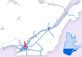
Quebec Autoroute 25
| ||||
|---|---|---|---|---|
| Autoroute Louis-H.-La Fontaine | ||||
 | ||||
| Route information | ||||
| Maintained by Transports Québec | ||||
| Length | 49.0 km (30.4 mi) | |||
| Existed | 1967[1] – present | |||
| Major junctions | ||||
| South end |
| |||
|
| ||||
| North end |
| |||
| Location | ||||
| Major cities | Boucherville, Montreal, Laval, Terrebonne, Mascouche | |||
| Highway system | ||||
| ||||


Autoroute 25 (or A-25, also called Autoroute Louis-H.-La Fontaine in Montreal) is an Autoroute in the Lanaudière region of Quebec. It is currently 49 km (30.4 mi) long and services the direct north of Montreal's Metropolitan Area. The A-25 has one toll bridge, which is the first modern toll in MMA and one of two overall in Quebec (after being joined by the A-30 toll bridge, which opened in 2012).
A-25 begins at an interchange with Autoroute 20 and Route 132 in Longueuil and quickly enters the Louis Hippolyte Lafontaine Bridge-Tunnel into the east end of Montreal. It is the main north-south freeway in the east end of Montreal (actually northwest-southeast but perpendicular to the St. Lawrence River).
Before the Montreal-Laval Extension, a gap existed in A-25 north of the interchange with Autoroute 40. Instead it followed Boulevard Henri-Bourassa to Boulevard Pie-IX, both of which are principal urban arterial roads. Boulevard Pie-IX north of Boulevard Henri-Bourassa was used as a temporary section of Autoroute 25 across the Rivière-des-Prairies to Autoroute 440. From there, A-25 proceeded east with A-440, then continued north and east of Laval.
The designation of Autoroute Louis-H.-Lafontaine is named after Louis Hippolyte Lafontaine, a 19th-century Lower Canada leader of what was then the Province of Canada.
A-25 is also part of the Trans-Canada Highway between the A-20 and A-40 interchanges.
History
Construction history
| Kilometre | Year | Notes | |
|---|---|---|---|
| 0 to 4 | 1967 | Louis Hippolyte Lafontaine Bridge-Tunnel | |
| 4 to 7 | 1966 | Avenue Souligny, Montreal to A-40/TCH, Montreal | |
| 7 to 10 | 2002 | A-40/TCH, Montreal to Boulevard Henri-Bourassa, Montreal | |
| 10 to 17 | 2011 | Boulevard Henri-Bourassa, Montreal to A-440, Laval | |
| 12 to 44 | 1971 | From A-440, Laval to Chemin du Ruisseau Saint-Jean, Saint-Roch-Ouest | |
| 44 to 46 | 1999 | Ruisseau Saint-Jean, Saint-Roch-Ouest to Rue Montcalm, Saint-Esprit | |
| 46 to end | 2001 | Rue Montcalm, Saint-Esprit to Route 125, Saint-Esprit | |
| Source:[2] | |||
Montreal-Laval Extension
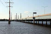
Autoroute 25 has been extended under a public-private partnership. The 7.2 km section of highway joins the southern part of Autoroute 25 at Boulevard Henri-Bourassa in Montreal's East end and the northern part at Laval's Autoroute 440. The $207-million project will save some $226 million for the province since a private consortium will assume any cost overruns. A toll bridge using a RFID transponder automatic payment system spans the Rivière des Prairies and costs transponder-owning motorists $3.20 per crossing at peak hours (6-9 AM and 3-6 PM) and $2.24 per crossing the rest of the day. An additional $5.34 in administration fees is charged for motorists without transponders. The road opened on May 21, 2011. The highway has six lanes (three in each direction), while the bridge features three lanes in each direction with one reserved for public transit.
Now that the link between Montreal and Laval is complete, the temporary autoroute section connecting Boulevard Pie-IX to Autoroute 440 lost its A-25 designation. The new route designation for this section is Route 125.
The new span effectively joins the North Shore, Laval, Montreal, and the South Shore. In addition, the completion of Autoroute 30 also created under a public-private partnership, will help reduce traffic in the City of Montreal by offering a southern by-pass route.
Environmental organizations have raised concerns that the highway extension will lead to an influx of automobiles entering Montreal and increase development pressure on agricultural land in Eastern Laval.[3][4]
Exit list
| Region | Location | km | mi | Exit | Destinations | Notes | |
|---|---|---|---|---|---|---|---|
| Continues as | |||||||
| Montérégie | Longueuil | 0.00 | 0.00 | A-20 exit 90; Route 132 exit 89 | |||
| Saint Lawrence River | Pont Louis-Hippolyte-La Fontaine | ||||||
| 1 | Île Charron, Îles-de-Boucherville Park | ||||||
| Tunnel Louis-Hippolyte-La Fontaine | |||||||
| Montréal | Montréal | 4 | Montréal Centre-Ville | Access via Avenue Souligny | |||
| 5 | Signed as exits 5E (east) and 5O (west) northbound | ||||||
| 6 | Rue Beaubien / Boulevard Yves-Prévost | Northbound exit is via exit 5O | |||||
| 7 | Boulevard Wilfrid-Pelletier / Boulevard Châteauneuf | Northbound exit and southbound entrance | |||||
| 8 | Signed as exits 8E (east) and 8O (west); A-40 exit 80 | ||||||
| 9 | Rue Bombardier / Boulevard Henri-Bourassa | No northbound signage for Boulevard Henri-Bourassa | |||||
| 10 | Boulevard Perras / Boulevard Maurice-Duplessis / Boulevard Henri-Bourassa | No southbound signage for Boulevard Henri-Bourassa | |||||
| Rivière des Prairies | Pont Olivier-Charbonneau (tolled) | ||||||
| Laval | 14 | No southbound signage for Route 125 | |||||
| 16 | Eastern terminus of A-440; exit 35 on A-440 | ||||||
| 20 | Boulevard des Mille Îles | ||||||
| Rivière des Mille Îles | Pont Lepage | ||||||
| 21 | Île Saint-Jean | ||||||
| Pont Mathieu | |||||||
| Lanaudière | Terrebonne | 22 | Northbound exit and southbound entrance; signed as exits 22E (east) and 22O (west) | ||||
| 23 | |||||||
| 24 | Southbound exit shares a ramp with exit 25 | ||||||
| 25 | Exit 42 on A-640 | ||||||
| – | Avenue de l'Esplanade | Standalone interchange that shares ramp with exit 25 | |||||
| Mascouche | 28 | Chemin Sainte-Marie – Mascouche Centre-Ville | |||||
| 30 | Chemin Saint-Pierre | ||||||
| 34 | Chemin Saint-Henri – L'Épiphanie | ||||||
| Saint-Roch-de-l'Achigan | 38 | Rue Armand-Majeau | Northbound exit and entrance | ||||
| 41 | Rang du Ruisseau-des-Anges South | ||||||
| Saint-Roch-Ouest | 44 | Southern terminus of unsigned concurrency with of Route 125 | |||||
| Saint-Esprit | 46 | ||||||
| – | Continuation north | ||||||
1.000 mi = 1.609 km; 1.000 km = 0.621 mi
| |||||||
See also
References
- ↑ "Répertoire des autoroutes du Québec" (in French). Transports Québec. Archived from the original on 2010-01-11. Retrieved 2008-02-23.
- ↑ Transports Québec: "Répertoire des autoroutes du Québec", 2007. Archived 2010-01-11 at the Wayback Machine.
- ↑ Conseil Régional de l'Environnement de Montréal. "L'AGRICULTURE SUR LE TERRITOIRE DE LA COMMUNAUTÉ MÉTROPOLITAINE DE MONTRÉAL ET LES IMPACTS DE LA PROLONGATION DE L'AUTOROUTE 25" (PDF). Retrieved 7 March 2011.
- ↑ Conseil Régional de l'environnement de Montréal. "10 raisons d'être contre le prolongement de l'autoroute 25" (PDF). CREMTL. Retrieved 7 March 2011.
External links
Route map:
| Wikimedia Commons has media related to Quebec Autoroute 25. |
- MTQ information sheet on 2010 construction of A-25 toll bridge segment between Montreal and Laval
- A-25 at Exitlists.com
- A-25 at Quebec Autoroutes
- Transports Quebec Map (in French)
- Autoroute 25 @ AsphaltPlanet.ca
| Preceded by |
Trans-Canada Highway |
Succeeded by |
| British Columbia | ||
|---|---|---|
| Alberta | ||
| Saskatchewan | ||
| Manitoba | ||
| Ontario | ||
| Quebec | ||
| New Brunswick | ||
| Prince Edward Island | ||
| Nova Scotia | ||
| Newfoundland | ||
| ||