Robert-Bourassa Boulevard — University Street
|
French: boulevard Robert-Bourassa rue University | |
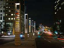 At the corner of De La Gauchetière, looking southward. | |
| Length | 2.1 km (1.3 mi) |
|---|---|
| Location |
Between Notre Dame Street and Pine Avenue
|
| Coordinates | 45°30′13″N 73°34′14″W / 45.503518°N 73.570496°W |
Robert Bourassa Boulevard (French: boulevard Robert-Bourassa), previously wholly named University Street (French: rue University),[1] is a major north-south artery in downtown Montreal, Quebec, Canada.
The street runs 2.1 km (1.3 mi), from the foot of Quebec Autoroute 10 to the former Royal Victoria Hospital. The portion named Robert Bourassa Boulevard extends from the terminus of Autoroute 10 in the south to Sherbrooke Street in the north. It runs for 1.2 km (0.75 mi). The portion named University Street extends from Sherbrooke Street in the south to Pine Avenue in the north. It runs for 0.9 km (0.56 mi).
Geography
The street ends in the south where the Bonaventure Expressway's northern terminus is (which is also the western terminus of the Eastern Townships Expressway (A10). It also runs south into two streets that parallel the expressway on each of its sides, Duke Street on the east side and Nazareth Street on the west side of the elevated highway. The street ends in the north at the Royal Victoria Hospital parking lot that separates its main campus from the Montreal Neurological Institute and McGill University's Molson Stadium, below Mount Royal Park.
Robert Bourassa Boulevard
Robert Bourassa links major cross-streets Sherbrooke Street, de Maisonneuve Boulevard, Sainte-Catherine Street, Rene Levesque Boulevard, Notre Dame Street.
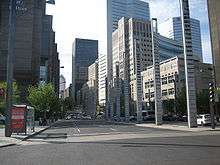
There are several notable buildings located on the southern portion of the street, these include Place Ville Marie, Place Bonaventure, Telus Tower and the world headquarters of ICAO.
At its southern end, the street forms the western boundary of the Montreal International Quarter, with a colonnade of pillars encasing a stylized representation of the flags of the world.[2]
University Street
_(2)%2C_Montreal_2005-08-30.jpg)
University links major cross-streets Sherbrooke Street, Pine Avenue.
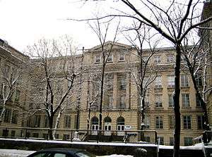
There are several notable buildings located on the southern portion of the street, these include McGill University, the High School of Montreal (now serving as the schoolgrounds for F.A.C.E. School) and the original Royal Victoria Hospital (mostly relocated in 2015).
Origins
University Street was named and inaugurated on November 30, 1842. The major part of this street, linking Dorchester (later renamed René Lévesque Boulevard) and Sherbrooke Street, was ceded by the descendants of Sir Thomas Phillips, a merchant, and an entrepreneur in construction, who became a city councillor in the 1840s. At the time, University ended at Sherbrooke Street, where a little path continued to McGill University, the institution from which the street got its name. It was eventually extended from Sherbrooke Street to just past Pine Avenue, where it reaches the base of Mount Royal and goes up alongside the former Royal Victoria Hospital.
McGill University has many of its buildings on the street.
On March 15, 2015, following a decision to rename the street, University was abridged to just the three blocks between Sherbrooke Street and Pine Avenue (ending slightly beyond at the base of Mount Royal).
Partial name change
On August 27, 2014, Montreal Mayor Denis Coderre announced that the part of University Street that runs through downtown Montreal would be renamed Robert Bourassa Boulevard, after the former premier of Quebec. This portion of the street stretches from Notre Dame through to Sherbrooke Street. Only a small section of the street, between McGill University and the former Royal Victoria Hospital, retained its original name. The official name change took effect on March 15, 2015.
Controversy
This change has not been without controversy. Some city officials have raised complaints that the change is political in nature and does not reflect the importance of McGill University in the development of that area.[3]
References
- ↑ "Le boulevard Robert-Bourassa : Un nouveau toponyme à partir du 15 mars 2015 dans l'arrondissement de Ville-Marie" (in French). ville.montreal.qc.ca. 15 March 2015. Retrieved 15 March 2015.
- ↑ Quartier international Web site
- ↑ http://tvanouvelles.ca/lcn/infos/regional/montreal/archives/2014/09/20140916-152317.html
Coordinates: 45°30′13″N 73°34′14″W / 45.503518°N 73.570496°W