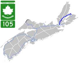
Nova Scotia Highway 105
| ||||
|---|---|---|---|---|
|
Mabel and Alexander Graham Bell Way Trans-Canada Highway | ||||
 | ||||
| Route information | ||||
| Maintained by Nova Scotia Department of Transportation and Infrastructure Renewal | ||||
| Length | 142 km[1] (88 mi) | |||
| Existed | 1970 – present | |||
| Major junctions | ||||
| West end |
| |||
|
Cabot Trail near Nyanza Cabot Trail near St. Anns | ||||
| East end |
| |||
| Highway system | ||||
|
Provincial highways in Nova Scotia
| ||||
.png)
Highway 105 in Nova Scotia represents the Cape Breton Island leg of the Trans-Canada Highway. It runs from the Port Hastings Rotary just east of the Canso Causeway in Port Hastings to the Marine Atlantic ferry terminal in North Sydney, representing a distance of 142 kilometres (88 mi).[1]
In 2010, the provincial government named the entire highway Mabel and Alexander Graham Bell Way in honour of Mabel Gardiner Hubbard and her husband Alexander Graham Bell, who resided and are buried at Beinn Bhreagh near Baddeck.[2]
Route description
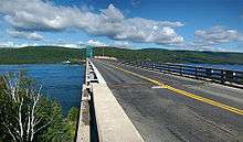
The highway travels northeast from Port Hastings along the base of a group of mountains known as "The Big Ridge" to Whycocomagh. It then follows the north shore of Bras d'Or Lake, bypassing Baddeck on a short Super two controlled access segment. Still running in a general northeast direction, at St. Anns the highway begins ascending the west slope of Kelly's Mountain on the Cape Dauphin Peninsula. Highway 105 descends the east slope of Kelly's Mountain using a series of sharp turns including a 180° hairpin turn at New Harris Forks before crossing the Great Bras d'Or Channel of Bras d'Or Lake on the Seal Island Bridge. The road crosses Boularderie Island using another short Super two controlled access segment and then runs southeast as an uncontrolled access road through the villages of Bras d'Or and Florence. Highway 105 regains controlled access for the final 3 km (1.9 mi) to its eastern terminus at the Marine Atlantic ferry terminal in North Sydney where travellers can continue to Newfoundland.
With some minor exceptions noted above, the highway is two lanes and uncontrolled access. In addition, there are two intersections controlled by traffic lights in Florence.
The Cabot Trail, which is usually used to describe a different road, is signed along a portion of Highway 105 between Nyanza and St. Anns so that the signed route forms a loop.
History
Highway 105 is descended from the former Trunk 5, which no longer exists; Highway 105 follows the old Trunk 5 alignment, using present Routes 205, 305 and roads named after it to serve areas bypassed by Highway 105. The 105 name was applied in 1970.
Trunk 5 was a provincial trunk road in Victoria County and the Cape Breton Regional Municipality between Boularderie East and Millville Boularderie on Boularderie Island in Nova Scotia. The route, known as Millville Highway, was the main highway before Nova Scotia Highway 105 opened. It originally extended from Sydney River to Port Hawkesbury. It is now commonly known as Old Route 5.
Exit list
References
- 1 2 3 Google (July 12, 2017). "Highway 105 in Nova Soctia" (Map). Google Maps. Google. Retrieved July 12, 2017.
- ↑ Transportation and Infrastructure Renewal (March 10, 2010). "Highway 105 Designated Mabel and Alexander Graham Bell Way". Government of Nova Scotia (Press release).
External links
Route map:

| Preceded by Highway 104 |
Trans-Canada Highway Highway 105 |
Succeeded by NL Route 1 |
| British Columbia | ||
|---|---|---|
| Alberta | ||
| Saskatchewan | ||
| Manitoba | ||
| Ontario | ||
| Quebec | ||
| New Brunswick | ||
| Prince Edward Island | ||
| Nova Scotia | ||
| Newfoundland | ||
| ||