Turcot Interchange
| Turcot Interchange | |
|---|---|
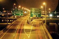 Approaching the Turcot Interchange from southbound A-15 | |
| Location | |
| Montreal, Quebec | |
| Coordinates | 45°28′04″N 73°35′58″W / 45.467776°N 73.599472°WCoordinates: 45°28′04″N 73°35′58″W / 45.467776°N 73.599472°W |
| Roads at junction |
|
| Construction | |
| Type | Stack interchange |
| Constructed |
1965 – 1967 2008 – 2016 |
| Opened | April 1967 |
The Turcot Interchange is a three-level stack freeway interchange within the city of Montreal, Quebec, Canada. Located southwest of downtown, the interchange links Autoroutes 15 (Décarie and Décarie South Expressways), 20 (Remembrance Highway), and 720 (Ville-Marie Expressway), and provides access to the Champlain Bridge via the Décarie South Expressway. It takes its name from the nearby Philippe-Turcot Street and Turcot village, which were in turn named after Philippe Turcot (1791-1861) who was a merchant owning land in Saint-Henri.[1]
Turcot is the largest interchange in the province and the third busiest interchange of Montreal (after Décarie and Anjou Interchanges, respectively) as of 2010, with numbers averaging a north-southbound flow of 278,000 approximate daily drivers, and over 350,000 west-eastbound in total. Moreover, Turcot is an occasional spot for road accidents as speed is only limited to 70 km/h (43 mph) on any of the interchange's directions (and the limit is often likely to be disregarded by the night drivers going over 100 km/h (62 mph)).
History
The interchange was projected as part of the first Montreal highway in 1958 and planned to bind it to the Decarie freeway, also designed at the same time. Construction started in October 1965 and Turcot was built in time for the 1967 Montreal Expo, along with other big projects such as the Montreal Metro.
Upon its erection, an old railroad yard belonging to the Grand Trunk Company (today merged into Canadian National) served as location for the interchange and was shortened by 25%, which required the demolition of a roundhouse. In 1969, upon reviewing the situation, city authorities concluded that the project abused unnecessary space and could have co-existed perfectly alongside the buildings that were otherwise demolished (including some 20 residences).
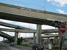
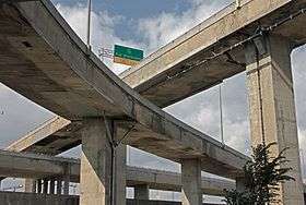
When originally constructed, nearly the entire interchange was built high above the ground because of the cliff existing between the Upper Lachine domain and the Turcot sorting yard overtaking the old Saint-Pierre Lake basin. The highest point of the interchange (62.5 metres or 205 feet) is located in its southern part over the Lachine Canal, which was built this high to allow for the passing of ships, even though the Canal closed its waterway operations just 3 years later, in 1970. Mean height of the interchange is some 40 metres (130 ft), which at the time of its inauguration, was considered to be both the highest freeway interchange in all of Canada, and a dramatic demonstration of Montreal's status as a modern global metropolis at the time.
The construction of the freeway junction was said to be rushed during the 1960s boom, with a lack of drainage and permeable concrete, and became in poor condition, with pieces of concrete slabs falling from overpass structures.[2]
In 2000, more than 300,000 vehicles used the interchange on a daily basis, far more than what it was designed to carry (50,000-60,000 vehicles ).
Since 2010, the interchange became subject to major repairs of the most heavily accessed ramps. During the summer of 2011, over 2.7 km worth of lanes were restored, repaved and returned to safely accessible condition for larger vehicles. The repairs are slated to continue into 2019, and remain a complication for the drivers until the new body of the A-20 is opened.
Reconstruction plans
In June 2007, the Quebec government announced the demolition and reconstruction of the structure, projected to be complete in 2016. The announcement came four years after a study on the interchange showed the Turcot structure was crumbling, with reports of concrete slabs up to one square metre falling from the overpasses.[3] In addition to a new interchange built lower to the ground, a large segment of Autoroute 20 would be rebuilt more to the north. Reconstruction of the interchange is expected to cost between $1.2 billion and $1.5 billion.[4]
Controversy
Around the time of its announcement, the project created controversy as to how Turcot should be rebuilt. Local residents and community groups have come out against the project as proposed by the government, claiming that it will worsen pollution, increase automobile traffic downtown, and require the demolition of housing including a significant portion of the Village des Tanneries neighbourhood.[5][6]
The project's environmental hearings ended June 19, 2009.[7] They revealed new plans for the area by CN,[8] as well as strong public desire to protect existing communities, rethink the modal balance of Montreal's urban transportation, and plan realistically for a future of energy shortages and environmental crisis.
After MDDEP conducted several environmental and technical impact investigations in early Summer of 2009, construction plans were halted because of the 2009 financial crisis.
Second project
In April 2010, the city of Montreal gathered all previous commentary reviewed by BAPE and announced a different reconstruction project, in which the railroad tracks and the main body of the A-20 are kept at their original location, the height of the interchange is basically maintained (but replaced with better-lasting materials), while the former Turcot Yards serve as ground for a new urban redevelopment district with its own community aspect. The cost of such proposition was set to at least $5 billion CAD, which is at least three times that of the original.
"If this project is to replace the original", stated the minister of Transports Quebec, Julie Boulet, "we can expect at least two more years of stalling", suggesting that Turcot should not be seen as a sandbox for any kind of proposals coming from all levels of the government. According to Gerald Tremblay, former mayor of Montreal, this was exactly the time necessary to prepare for the works, which were postponed into the second half of 2012.
Groundbreaking and Angrignon exit reconfiguration
Starting February 2012, the MTQ proceeded to hire excavation companies in order to start the ground leveling of the former yards in terms of the future project. The westbound lanes of the A-20 were to be moved to that location, and Boulet confirmed that the reconfiguration of the Ste-Anne-de-Bellevue—Pullman—Angrignon interchange would take place, and is scheduled to be completed in 2018. Just as foreseen in the project, the part of the Angrignon Blvd. used as an exit overpass from the A-20 will be moved some 300 meters westward, forming the second half of the Sainte-Anne-de-Bellevue blvd intersection. The original part of Pullman street, consisting of a flow way between Angrignon and Sainte-Anne, simply ceased to exist.
As of April 2014, it could be seen that the works were underway near the interchange itself, and some existing streets/exits/entrances (Girouard, Crowley (after the CUSM completion), Côte-Saint-Paul, Angrignon/Pullman) had been reconfigured to accept the new flow once the body of the A-20 was moved northward. The new completion date was set for July 1, 2019. In October 2016, a large part of the old interchange was closed, allowing the continuous work of the new interchange.
Turcot Interchange in popular culture
Famous Quebec folk singer Plume Latraverse, beacon of the late 1960s counterculture and key figure at the 1976 Montreal Olympics, compared Turcot to the "functional heart" of the city, with its inward ramps being the arteries and outward ramps being the veins. One of his late 1970s songs features these lyrics.
Turcot was the setting for writer-director René Balcer's 1978 short film Turcot Interchange,[9] a dark rom-com.
Since late 1990s, the abandoned space underneath the ramps has become a place of urban gatherings for certain graffiti artists. The artistic trio "Flow", which was also rooted in Montreal in 1993 and has long ever since moved on, is involved in producing one of the paintings on the westbound A-20 ramp, titled "Smashing All Toys". With criminal activity on the rise in Saint-Henri in the first half of the 2000s, this space has also been high on drug dealers and violence gangs, subsequently cleared by the SPVM by 2010.
Today, the area is used as a park by many local residents, who claim that because of the height of the ramps, there is almost no pollution from the passing cars.
See also
References
- ↑ "Échangeur Turcot". www.toponymie.gouv.qc.ca. Commission de toponymie Quebec. Retrieved 30 June 2017.
- ↑ "Montreal is falling down". Maclean's. 2011-08-23. Retrieved 2016-12-27.
- ↑ "Concrete crumbling onto highway: report". CBC News. 2003-05-16. Retrieved 2007-03-14.
- ↑ "Reconstruction du complexe Turcot, à Montréal" (in French). Transports Québec. Retrieved 2008-08-25.
- ↑ "TURCOT: A disaster in the making". Turcot Mobilization. Archived from the original on 2008-08-20. Retrieved 2008-08-25.
- ↑ Johnston, David (2008-09-26). "Saving Cazelais St". Montreal Gazette. Canwest. Archived from the original on 2012-07-22. Retrieved 2008-09-29.
- ↑ Prince, Jason (2009-10-21). "Bape Hearings". turcot.ca. Archived from the original on 2012-07-22. Retrieved 2010-01-20.
- ↑ Carruthers, Alex (2009-06-27). "Bape Hearings". turcot.ca. Archived from Announces New Rail Line/ the original Check
|url=value (help) on 2016-03-03. Retrieved 2010-01-20. - ↑
External links
| Wikimedia Commons has media related to Turcot Interchange. |
- Turcot Interchange page on the Transports Québec Website
- Mobilisation Turcot