Emigration Canyon, Utah
|
Emigration Canyon | |
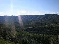 Emigration Canyon 2006 | |
  | |
| Location | Salt Lake County, Utah, USA |
|---|---|
| Coordinates | 40°46′N 111°46′W / 40.767°N 111.767°WCoordinates: 40°46′N 111°46′W / 40.767°N 111.767°W |
| Area | 25 acres (10 ha) (landmarked area) |
| Built | 1847 |
| NRHP reference # | 66000737 |
| Significant dates | |
| Added to NRHP | October 15, 1966[1] |
| Designated NHL | January 20, 1961[2] |
Emigration Canyon is a census-designated place (CDP), township and canyon in Salt Lake County, Utah, United States, located east of Salt Lake City in the Wasatch Range. Beginning at the southern end of the University of Utah, the canyon itself heads east and northeast between Salt Lake City and Morgan County. The boundaries of the CDP and township are coextensive; they do not extend to the county line. As of the 2010 census, the population was 1,567.
A portion of Emigration Canyon, located in This Is the Place Heritage Park, was declared a National Historic Landmark in 1961 for the canyon's significance in the Mormon migration of the 19th century.[3]
History
Emigration Canyon was significant in early Utah history as the original route used by pioneers entering the area. It was part of the Hastings Cutoff route used by the Donner Party in 1846, and where the Mormon Pioneers entered the Salt Lake Valley in 1847. As Brigham Young looked over the canyon, he declared, "This is the right place. Drive on." These words have become famous in Utah history. The event is commemorated with This Is The Place Heritage Park at the mouth of the canyon. Throughout Emigration Canyon, there are several historic markers designating camps, trail markers and milestone where the Mormon Pioneers passed while on their way to the Salt Lake Valley. One example of these milestones is called Lost Creek Camp.
Local attractions
Hogle Zoo, the main zoo in the Salt Lake City area, also lies at the mouth of the canyon. Emigration Canyon is home to Camp Kostopulos, established in 1967 by the Kostopulos Dream Foundation as a summer camp for disabled children, teens, and adults. It is adjacent to the historic Ruth's Diner, established in 1930.
Cycling
Emigration Canyon is one of most accessible canyon rides from Salt Lake City. With a length of 7.7 miles and an average grade of 5 percent, there is approximately 1,300 feet of elevation gain from the mouth to the top, which cyclists often refer to as "Little Mountain". There is a good shoulder to ride in and locals are used to bicycle traffic. There are restrooms located at the bottom of the canyon and the top, but these may be closed during winter months.
Proposed development
Much of Emigration Canyon is protected within the Uinta-Wasatch-Cache National Forest.[4] With its proximity to Salt Lake City, unprotected areas have been of interest to property developers; since 2001, the Utah Open Lands Conservation Association has raised funds to preserve numerous parcels of land in the canyon, totalling over 260 acres (110 ha) as of 2016.[5]
See also
References
- ↑ National Park Service (2007-01-23). "National Register Information System". National Register of Historic Places. National Park Service.
- ↑ "Emigration Canyon". National Historic Landmark summary listing. National Park Service. Archived from the original on 2007-10-18. Retrieved 2008-04-01.
- ↑ "NHL nomination for Emigration Canyon". National Park Service. Retrieved 2018-03-13.
- ↑ "Unita-Wasatch-Cache National Forest". United States Forest Service. U.S. Dept. of Agriculture. Retrieved 2017-12-28.
- ↑ "Owl Meadow Saved!". Utah Open Lands Conservation Association. 2016-09-26. Retrieved 2017-12-27.
External links
| Wikimedia Commons has media related to Emigration Canyon, Utah. |
Places adjacent to Emigration Canyon, Utah | |
|---|---|
Municipalities and communities of Salt Lake County, Utah, United States | ||
|---|---|---|
| Cities | 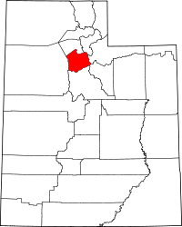 | |
| Town | ||
| Townships | ||
| CDPs | ||
| Unincorporated community | ||
| Ghost towns | ||
| Footnotes | ‡This populated place also has portions in an adjacent county or counties | |
Mormon Trail landmarks | ||
|---|---|---|
| Illinois |  | |
| Nebraska | ||
| Wyoming | ||
| Utah | ||
| Topics | |
|---|---|
| Lists by states |
|
| Lists by insular areas | |
| Lists by associated states | |
| Other areas | |
| |