Cochrane District
| Cochrane District District de Cochrane | |
|---|---|
| District | |
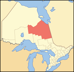 Location of Cochrane District in Ontario | |
| Coordinates: 50°30′N 83°00′W / 50.500°N 83.000°WCoordinates: 50°30′N 83°00′W / 50.500°N 83.000°W | |
| Country |
|
| Province |
|
| Region | Northeastern Ontario |
| Created | 1921 |
| Seat | Cochrane |
| Area[1] | |
| • Land | 141,270.41 km2 (54,544.81 sq mi) |
| Population (2016)[2] | |
| • Total | 79,682 |
| • Density | 0.6/km2 (2/sq mi) |
| Time zone | UTC-5 (EST) |
| • Summer (DST) | UTC-4 (EDT) |
| Area code(s) | 705 |
Cochrane District is a district and census division in Northeastern Ontario in the Canadian province of Ontario. It was created in 1921 from parts of Timiskaming and Thunder Bay districts.
In 2016, the population was 79,682. The land area of this district is 141,270.41 square kilometres (54,544.81 sq mi),[1] making it slightly smaller than the US State of Michigan and the second largest district in Ontario after Kenora District. The district seat is Cochrane.
Bennet Lake Esker Kame Complex Conservation Reserve is located in Cochrane District.
Subdivisions
City
| Name of City | Population | Ref. |
|---|---|---|
| Timmins | 41,788 |
Towns
| Name of Town | Population | Ref. |
|---|---|---|
| Cochrane | 5,321 | |
| Hearst | 5,500 | |
| Iroquois Falls | 4,537 | |
| Kapuskasing | 8,292 | |
| Moosonee | 1,725 | |
| Smooth Rock Falls | 1,330 |
Townships
| Name of Township | Population | Ref. |
|---|---|---|
| Black River-Matheson | 2,410 | |
| Fauquier-Strickland | 530 | |
| Mattice-Val Côté | 686 | |
| Moonbeam | 1,231 | |
| Opasatika | 214 | |
| Val Rita-Harty | 817 |
Cree Nation reserves
Unorganized areas
- North Part (includes the local services boards of Hallébourg, Jogues, Lac-Sainte-Thérèse, and Moose Factory)
- South East Part
- South West Part
Geographic Townships
This list is incomplete.
Demographics
| Canada census – Cochrane District community profile | |||
|---|---|---|---|
| 2016 | 2011 | 2006 | |
| Population: | 79,682 (-1.8% from 2011) | 81,122 (-1.7% from 2006) | 82,503 (-3.2% from 2001) |
| Land area: | 141,270.41 km2 (54,544.81 sq mi) | 141,247.30 km2 (54,535.89 sq mi) | |
| Population density: | 0.6/km2 (1.6/sq mi) | 0.6/km2 (1.6/sq mi) | |
| Median age: | 40.7 (M: 40.3, F: 41.1) | ||
| Total private dwellings: | 37,974 | 37,242 | 37,253 |
| Median household income: | |||
| Notes: Excludes census data for one or more incompletely enumerated Indian reserves. – References: 2016[2] 2011[1] 2006[3] earlier[4] | |||
See also
References
- 1 2 3 "2011 Community Profiles". Canada 2011 Census. Statistics Canada. July 5, 2013. Retrieved 2012-03-19.
- 1 2 "2016 Community Profiles". Canada 2016 Census. Statistics Canada. February 21, 2017.
- ↑ "2006 Community Profiles". Canada 2006 Census. Statistics Canada. March 30, 2011. Retrieved 2012-03-19.
- ↑ "2001 Community Profiles". Canada 2001 Census. Statistics Canada. February 17, 2012.
| Wikimedia Commons has media related to Cochrane District, Ontario. |
Places adjacent to Cochrane District | ||||||||||
|---|---|---|---|---|---|---|---|---|---|---|
| ||||||||||
| City |  | |
|---|---|---|
| Towns | ||
| Townships | ||
| First Nations | ||
| Indian reserves | ||
| Indian settlements | ||
| Unorganized territories | ||
| Local services boards | ||
| Unincorporated communities |
| |
| ||
| Regions | |
|---|---|
| Counties | |
| Districts | |
| Regional municipalities | |
| Single-tier municipalities | |
| Separated municipalities | |
| |
This article is issued from
Wikipedia.
The text is licensed under Creative Commons - Attribution - Sharealike.
Additional terms may apply for the media files.