Nipissing District
| Nipissing District District de Nipissing | |
|---|---|
| District | |
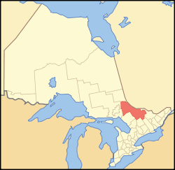 Location of Nipissing District in Ontario | |
| Coordinates: 46°18′00″N 79°27′00″W / 46.30000°N 79.45000°WCoordinates: 46°18′00″N 79°27′00″W / 46.30000°N 79.45000°W | |
| Country |
|
| Province |
|
| Region | Northeastern Ontario |
| Created | 1858 |
| Government | |
| • MPs | Anthony Rota, Cheryl Gallant, Marc Serré |
| • MPPs | Vic Fedeli, John Vanthof, John Yakabuski |
| Area[1] | |
| • Land | 17,103.52 km2 (6,603.71 sq mi) |
| Population (2016)[2] | |
| • Total | 83,150 |
| • Density | 4.9/km2 (13/sq mi) |
| Time zone | UTC-5 (Eastern (EST)) |
| • Summer (DST) | UTC-4 (EDT) |
| Postal code FSA | P0A, P0B, P1A-P1C, P2B |
| Area code(s) | 705 |
| Seat | North Bay |
Nipissing District is a district in Northeastern Ontario in the Canadian province of Ontario. It was created in 1858. The district seat is North Bay.
In 2016, the population was 83,150. The land area is 17,103.52 square kilometres (6,603.71 sq mi); the population density was 4.9 per square kilometre (13/sq mi), making it one of the most densely populated districts in Northern Ontario.[1]
History
The Sudbury District was created in 1894 from townships of eastern Algoma District and west Nipissing District.
Subdivisions
City
Towns
In addition, the eastern part of the town of Kearney is within Nipissing District, but the entire town is enumerated with the Parry Sound District.
Townships
Unorganized areas
Local services boards in these unorganized areas include:
First Nation reserves
Demographics
| Canada census – Nipissing District community profile | |||
|---|---|---|---|
| 2016 | 2011 | 2006 | |
| Population: | 83,150 (-1.9% from 2011) | 84,736 (0.1% from 2006) | 84,688 (2.1% from 2001) |
| Land area: | 17,103.52 km2 (6,603.71 sq mi) | 17,065.07 km2 (6,588.86 sq mi) | |
| Population density: | 5.0/km2 (13/sq mi) | 5.0/km2 (13/sq mi) | |
| Median age: | 42.2 (M: 41.3, F: 43.0) | ||
| Total private dwellings: | 41,200 | 41,023 | 40,073 |
| Median household income: | |||
| Notes: Excludes census data for one or more incompletely enumerated Indian reserves. – References: 2016[2] 2011[1] 2006[3] earlier[4] | |||
See also
| Wikimedia Commons has media related to Nipissing District, Ontario. |
References
- 1 2 3 "2011 Community Profiles". Canada 2011 Census. Statistics Canada. July 5, 2013. Retrieved 2012-03-19.
- 1 2 "2016 Community Profiles". Canada 2016 Census. Statistics Canada. February 21, 2017.
- ↑ "2006 Community Profiles". Canada 2006 Census. Statistics Canada. March 30, 2011. Retrieved 2012-03-19.
- ↑ "2001 Community Profiles". Canada 2001 Census. Statistics Canada. February 17, 2012.
Places adjacent to Nipissing District | |
|---|---|
| Cities | 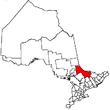 | |
|---|---|---|
| Towns | ||
| Townships | ||
| First Nations | ||
| Indian reserves | ||
| Unorganized areas | ||
| Local services boards | ||
| ||
| Regions | |
|---|---|
| Counties | |
| Districts | |
| Regional municipalities | |
| Single-tier municipalities | |
| Separated municipalities | |
| |
This article is issued from
Wikipedia.
The text is licensed under Creative Commons - Attribution - Sharealike.
Additional terms may apply for the media files.