Jogues, Ontario
| Jogues | |
|---|---|
|
dispersed rural community unincorporated area | |
 | |
 Jogues Location in Ontario | |
| Coordinates: 49°35′51″N 83°44′44″W / 49.59750°N 83.74556°WCoordinates: 49°35′51″N 83°44′44″W / 49.59750°N 83.74556°W[1] | |
| Country | Canada |
| Province | Ontario |
| District | Cochrane |
| Geographic Township | Way |
| Area | |
| • Total | 79.37 km2 (30.64 sq mi) |
| Elevation[2] | 256 m (840 ft) |
| Population (2011) | |
| • Total | 325 |
| • Density | 4.1/km2 (11/sq mi) |
| Time zone | UTC-5 (Eastern Time Zone) |
| • Summer (DST) | UTC-4 (Eastern Time Zone) |
| Postal Code | P0L |
| Area code(s) | 705, 249 |
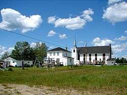
Jogues is a dispersed rural community and unincorporated place in geographic Way Township,[3] Cochrane District in Northeastern Ontario, Canada.[1] It is about 11 kilometres (6.8 mi) southwest of Hearst (about 10–15 minutes by vehicle). Jogues is also a designated place served by a local services board.
The community is located on Ontario Highway 583 and the Algoma Central Railway; the railway location is also known as Stavert.[3] In the case of the railway, Jogues lies between the communities of Coppell to the south and Wyborn (today part of and on the west side of Hearst) to the north; and in the case of the highway, between Coppell to the south and central Hearst to the north.
The community is mainly French-speaking, has a church, and children are bussed to Hearst for school.
Demographics
Jogues had a population of 325 in the Canada 2011 Census. In previous census data it was counted as part of Unorganized Cochrane North Part.
| Canada census – Jogues, Ontario community profile | |||
|---|---|---|---|
| 2011 | 2006 | ||
| Population: | 325 (-8.2% from 2006) | 354 (% from 2001) | |
| Land area: | 79.37 km2 (30.64 sq mi) | ||
| Population density: | 4.1/km2 (11/sq mi) | ||
| Median age: | |||
| Total private dwellings: | 136 | ||
| Median household income: | |||
| References: 2011[4] 2006[5] earlier[6] | |||
References
- 1 2 "Jogues". Geographical Names Data Base. Natural Resources Canada. Retrieved 2014-08-29.
- ↑ Taken from Google Earth at geographic coordinates, accessed 2014-08-29.
- 1 2 "Way" (PDF). Geology Ontario - Historic Claim Maps. Ontario Ministry of Northern Development, Mines and Forestry. Archived from the original (PDF) on 2014-09-03. Retrieved 2014-08-29.
- ↑ "2011 Community Profiles". Canada 2011 Census. Statistics Canada. July 5, 2013.
- ↑ "2006 Community Profiles". Canada 2006 Census. Statistics Canada. March 30, 2011.
- ↑ "2001 Community Profiles". Canada 2001 Census. Statistics Canada. February 17, 2012.
Other map sources:
- Map 14 (PDF) (Map). 1 : 1,600,000. Official road map of Ontario. Ministry of Transportation of Ontario. 2010-01-01. Retrieved 2014-08-29.
- Restructured municipalities - Ontario map #3 (Map). Restructuring Maps of Ontario. Ontario Ministry of Municipal Affairs and Housing. 2006. Retrieved 2014-08-29.
| City | 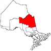 | |
|---|---|---|
| Towns | ||
| Townships | ||
| First Nations | ||
| Indian reserves | ||
| Indian settlements | ||
| Unorganized territories | ||
| Local services boards | ||
| Unincorporated communities |
| |
| ||