Oxford County, Ontario
| Oxford County | |
|---|---|
| Regional municipality (upper-tier) | |
| County of Oxford | |
| Motto(s): Growing Stronger, Together | |
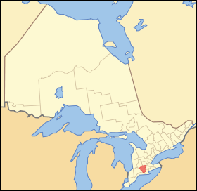 Map showing Oxford County location in Ontario | |
| Coordinates: 42°58′N 80°48′W / 42.967°N 80.800°WCoordinates: 42°58′N 80°48′W / 42.967°N 80.800°W | |
| Country |
|
| Province |
|
| Incorporated | 1850 |
| Area[1] | |
| • Land | 2,036.61 km2 (786.34 sq mi) |
| Population (2016)[1] | |
| • Total | 110,862 |
| • Density | 54.4/km2 (141/sq mi) |
| Time zone | UTC-5 (Eastern (EST)) |
| • Summer (DST) | UTC-4 (Eastern (EDT)) |
| Website | www.oxfordcounty.ca |
Oxford County is a regional municipality in the Canadian province of Ontario, located in the Southwestern portion of the province. The regional seat is in Woodstock. Oxford County has been a regional municipality since 2001, despite still having the word "county" in its name. It comprises a single Statistics Canada census division, and a single electoral division for federal and provincial elections.
Subdivisions
Oxford County consists of eight municipalities (in order of population):
- City of Woodstock
- Town of Tillsonburg
- Town of Ingersoll
- Township of Norwich
- Township of Zorra
- Township of South-West Oxford
- Township of Blandford-Blenheim
- Township of East Zorra-Tavistock
History
The identity of the first white settler remains a subject of controversy, but local legend has it that in 1793, Abraham Canfield a United Empire Loyalist from Connecticut, settled in the "Township of Oxford on the Thames".
Oxford County was created by the legislature of the province of Upper Canada in 1798, by an enactment which came into force at the beginning of the year 1800. The immediate purpose was to better organize the local militia and improve social order through the appointment of a [lieutenant], part of the framework for the province which had been put in place several years earlier by Governor Simcoe. The county lieutenant appointed for Oxford County was William Claus, a grandson of Sir William Johnson, and at the time head of the Indian Department responsible for oversight of the Six Nations settled along the Grand River tract running north and south on the eastern boundary of Oxford.[2]
As first established, Oxford County consisted of the townships of Blenheim, Burford, Oxford-on-the-Thames, Norwich and Dereham (lands to the north of the Thames River had not yet been purchased by the Crown). The first three of these had been receiving settlers since 1793, under the leadership of Thomas Hornor (Blenheim), Benajah Mallory (Burford) and Thomas Ingersoll (Oxford-on-the-Thames), each of whom was also captain of the militia in his respective township. Claus remained resident in Niagara and his appointmnt as the Crown's head for the county set off a rivalry between Hornor and Mallory for the prestige of appointment as Claus' resident deputy lieutenant within the county, eventually won by Hornor.[3]
Local government in the early days of Upper Canada took place through appointment of officers at an annual town meeting in each township, and through decisions made at the district level during quarter sessions. In 1788, the Hesse District was established within Upper Canada covering the territory of what is today southwestern Ontario. Four years later it became the Western District with the establishment of Norfolk County which included the territory of present-day Oxford County. In 1798, these lands were included into a new London District. The Brock District, containing the Oxford County territory, was then split off from the London District in 1840, after Upper Canada had been replaced by the Canada West portion of the Province of Canada governance.
The boundaries of Oxford county for most of its existence were established in 1850 with the implementation of the Baldwin Act. In 1855, Norwich Township in the county's southeast was divided into North and South townships to accommodate significant population levels in that area. Except for this adjustment, the township boundaries within the county remained intact until the late 20th century.
On 1 January 1975, major revisions to Oxford County's structure took effect when the townships were reduced to the current five under an amalgamation. Three urban municipalities also remained, namely Ingersoll, Tillsonburg and Woodstock. Today's county boundaries also show slight adjustments to include the urban areas of Tavistock in the north and of Tillsonburg in the south.
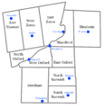 Townships from 1855 to 1975, with selected communities in blue.
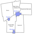 Oxford County municipal boundaries today, as established in 1975.
Demographics
| Canada census – Oxford County, Ontario community profile | |||
|---|---|---|---|
| 2011 | 2006 | ||
| Population: | 105,719 (2.9% from 2006) | 102,756 (3.5% from 2001) | |
| Land area: | 2,039.56 km2 (787.48 sq mi) | 2,039.46 km2 (787.44 sq mi) | |
| Population density: | 51.8/km2 (134/sq mi) | 50.4/km2 (131/sq mi) | |
| Median age: | 39.8 (M: 38.6, F: 40.9) | ||
| Total private dwellings: | 43,367 | 40,625 | |
| Median household income: | |||
| References: 2011[4] 2006[5] earlier[6] | |||
Historic populations:[6]
- Population in 2001: 99,270
- Population in 1996: 97,142
Policing
Because of its designation as a regional municipality, Oxford County has a regional-level police force, titled the Woodstock Police Service. However, a few communities such as Ingersoll, Norwich and Tillsonburg are patrolled by the Ontario Provincial Police (OPP) Oxford detachment, with Ingersoll formerly having its own independent police service for many years before merging with the OPP.[7] Recently many townships opted to remove OCPS from service and now relies upon the OPP. OCPS has become the Woodstock Police Service and now only serves inside Woodstock city limits.
See also
References
- 1 2 Census Profile, 2016 Census
- ↑ William Claus, Dictionary of Canadian Biography, Vol. VI
- ↑ Major R.C. Muir, The Early Political and Military History of Burford (1913)
- ↑ "2011 Community Profiles". Canada 2011 Census. Statistics Canada. July 5, 2013. Retrieved 2012-03-27.
- ↑ "2006 Community Profiles". Canada 2006 Census. Statistics Canada. March 30, 2011. Retrieved 2012-03-27.
- 1 2 "2001 Community Profiles". Canada 2001 Census. Statistics Canada. February 17, 2012.
- ↑ www.cooloxford.ca
External links
| Wikimedia Commons has media related to Oxford County, Ontario. |
- County of Oxford, Ontario Canada Official website
- Information Oxford
- Oxford County: History
- McGill University, The Digital Collections Program: 1880 map of Ontario Counties
Places adjacent to Oxford County, Ontario | |
|---|---|
| Regions | |
|---|---|
| Counties | |
| Districts | |
| Regional municipalities | |
| Single-tier municipalities | |
| Separated municipalities | |
| |