| Parry Sound District |
|---|
|
District |
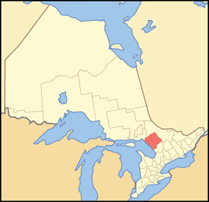
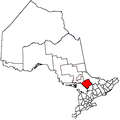
Location of Parry Sound District in Ontario |
|
Coordinates: 45°42′N 79°50′W / 45.700°N 79.833°W / 45.700; -79.833Coordinates: 45°42′N 79°50′W / 45.700°N 79.833°W / 45.700; -79.833 |
| Country |
 Canada Canada |
|---|
| Province |
 Ontario Ontario |
|---|
| Region |
Northern Ontario and Central Ontario |
|---|
| Created |
1870 |
|---|
| Government |
|---|
| • MPs |
Tony Clement, Anthony Rota, Marc Serré |
|---|
| • MPPs |
Norm Miller, Vic Fedeli |
|---|
| Area[1] |
|---|
| • Land |
9,322.80 km2 (3,599.55 sq mi) |
|---|
| Population (2016)[2] |
|---|
| • Total |
42,824 |
|---|
| • Density |
4.5/km2 (12/sq mi) |
|---|
| Time zone |
UTC-5 (EST) |
|---|
| • Summer (DST) |
UTC-4 (EDT) |
|---|
| Postal code FSA |
P0C, P0E, P0G, P0H, P2A |
|---|
| Area code(s) |
705 |
|---|
| Seat |
Parry Sound |
|---|
Parry Sound District is a census division of the Canadian province of Ontario. Its boundaries are District of Muskoka to the south, the Sudbury District to the north-northwest, the French River and Lake Nipissing in the north, Nipissing District and North Bay in the north and east and parts of Algonquin Park in the northeast.
In 2016, the population was 42,824. The land area is 9,322.80 square kilometres (3,600 sq mi); the population density was 4.5 per square kilometre (12/sq mi).[2]
Although geographically in Southern Ontario, the Ontario and federal governments treat it as it part of Northern Ontario. Like other census divisions in Northern Ontario, it does not have an incorporated county, regional municipality or district municipality level of government, instead serving as a purely territorial division like the other districts of Northern Ontario. In lieu of an upper tier of municipal administration, all government services in the district are provided either by the local municipalities or by the provincial government itself. Some communities which are not part of any incorporated municipality are served by local services boards. The district is also included in the service areas of FedNor and the Northern Ontario Heritage Fund. Accordingly, in most contexts the division is grouped with the Northern Ontario region instead of Southern Ontario.
Along with the neighbouring Muskoka and Haliburton regions, the Parry Sound District is considered part of Ontario's cottage country region. The district is commonly divided into two subregions; West Parry Sound and East Parry Sound, the latter often referred to as the Almaguin Highlands.
Subdivisions
Census subdivisions in Parry Sound District
| Towns |
|
| Townships |
|
| Villages |
|
| Unorganized areas |
Local services boards in the unorganized areas:
|
| First Nation reserves |
|
Original geographic townships
Demographics
| Canada census – Parry Sound District community profile |
|---|
|
2016 |
2011 |
2006 |
| Population: |
42,824 (1.6% from 2011) |
42,162 (3.0% from 2006) |
40,918 (3.2% from 2001) |
| Land area: |
9,326.48 km2 (3,600.97 sq mi) |
9,322.80 km2 (3,599.55 sq mi) |
9,222.04 km2 (3,560.65 sq mi) |
| Population density: |
4.6/km2 (12/sq mi) |
4.5/km2 (12/sq mi) |
4.4/km2 (11/sq mi) |
| Median age: |
52.6 (M: 52.3, F: 53.0) |
|
47.9 (M: 47.3, F: 48.4) |
| Total private dwellings: |
35,226 |
33,764 |
35,404 |
| Median household income: |
|
|
$46,180 |
| References: 2016[2] 2011[1] 2006[3] earlier[4] |
- 93.8% White
- 5.5% Aboriginal (3.8% First Nations, 1.5% Métis)
- 0.7% Visible Minorities
Forest fire protection history
The Parry Sound Forest Fire District was founded by Ontario's former Department of Lands and Forests (now the MNR) in 1922 as one of 17 districts to help protect Ontario's forests from fire by early detection from fire towers. The headquarters for the district were housed in the town of Parry Sound. It was the central location for 21 fire tower lookouts, including the Parry Sound fire tower, which was erected in the same location as the modern lookout tower at 17 George Street. The other 20 towers in the district were: Pickerel River CPR, Byng Inlet, Still River, Pointe au Baril, Pakesley, Pickerel River CNR, Key Junction, Ardbeg, Spence, Go Home, Loring, Stormy Lake (Restoule), Nipissing, Boulter, Lount, Laurier, Strong, Proudfoot, Stisted and Draper. When a fire was spotted in the forest a towerman would get the degree bearings from his respective tower and radio back the information to headquarters. When one or more towermen from other towers in the area would also call in their bearings, the forest rangers at headquarters could get a 'triangulation' read and plot the exact location of the fire on their map. This way a team of forest firefighters could be dispatched as soon as possible to get the fire under control. In 1969 there remained only 4 actively manned towers: Ardbeg, Go Home, Stormy Lake, and Boulter. These would all be phased out shortly after when aerial fire fighting techniques were employed in the 1970s.
External links
Places adjacent to Parry Sound District |
|---|
|
|
|---|
| Towns | | |
|---|
| Townships | |
|---|
| Villages | |
|---|
| First Nations | |
|---|
| Indian reserves | |
|---|
| Local services boards | |
|---|
| Unorganized areas | |
|---|
|