Val Rita-Harty
| Val Rita-Harty | |
|---|---|
| Township municipality (single-tier) | |
|
Township of Val Rita-Harty Canton de Val Rita-Harty | |
 Val Rita | |
| Motto(s): In Uno Spiritu (Latin: "One in spirit") | |
 Val Rita-Harty Location in Ontario | |
| Coordinates: 49°29′02″N 82°37′47″W / 49.48389°N 82.62972°WCoordinates: 49°29′02″N 82°37′47″W / 49.48389°N 82.62972°W[1] | |
| Country |
|
| Province |
|
| District | Cochrane |
| Settled | 1922 |
| Incorporated | 1973 |
| Government | |
| • Mayor | Johanne Baril |
| • MPs | Carol Hughes (NDP) |
| • MPPs | Gilles Bisson |
| Area[2] | |
| • Land | 381.19 km2 (147.18 sq mi) |
| Population (2016)[2] | |
| • Total | 762 |
| • Density | 2.0/km2 (5/sq mi) |
| Time zone | UTC-5 (Eastern Time Zone (EST)) |
| • Summer (DST) | UTC-4 (Eastern Time Zone (EDT)) |
| Postal code | P0L 2G0 |
| Area code(s) | 705,249 |
| Website |
www |
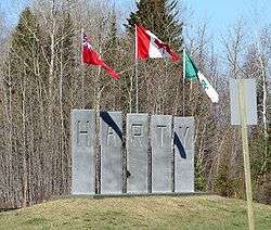
Welcome sign in Harty
Val Rita-Harty is a township municipality in Cochrane District in Northeastern Ontario, Canada.[1][3][4][5][6]
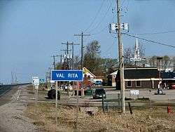
The township consists of two communities, Val Rita and Harty, both located along Highway 11 between Opasatika and Kapuskasing. It was incorporated as a township in 1973, following a failed community effort in 1964 to request incorporation as a municipality.
Demographics
| Canada census – Val Rita-Harty (3556070) community profile | |||
|---|---|---|---|
| 2016 | 2011 | 2006 | |
| Population: | 762 (-6.7% from 2011) | 817 (-13.0% from 2006) | 939 (-8.1% from 2001) |
| Land area: | 381.18 km2 (147.17 sq mi) | 382.71 km2 (147.77 sq mi) | 382.64 km2 (147.74 sq mi) |
| Population density: | 2.0/km2 (5.2/sq mi) | 2.1/km2 (5.4/sq mi) | 2.5/km2 (6.5/sq mi) |
| Median age: | 46.6 (M: 47.2, F: 45.9) | 40.0 (M: 40.8, F: 39.9) | |
| Total private dwellings: | 330 | 368 | 384 |
| Median household income: | $53,125 | ||
| References: 2016[2] 2011[7] 2006[8] earlier[9] | |||
Population:[10]
- Population in 1996: 1112
- Population in 1991: 1178
Mother tongue (as of 2016):[2]
- English as first language: 22.2%
- French as first language: 74.5%
- English and French as first language: 1.3%
- Other as first language: 2%
See also
References
- 1 2 "Val Rita-Harty". Geographical Names Data Base. Natural Resources Canada. Retrieved 2018-09-07.
- 1 2 3 4 "2016 Community Profiles". Canada 2016 Census. Statistics Canada. February 21, 2017. Retrieved 2018-09-07.
- ↑ "Toporama (on-line map and search)". Atlas of Canada. Natural Resources Canada. Retrieved 2018-09-07.
- ↑ "Ontario Geonames GIS (on-line map and search)". Ontario Ministry of Natural Resources and Forestry. 2014. Retrieved 2018-09-07.
- ↑ Map 14 (PDF) (Map). 1 : 1,600,000. Official road map of Ontario. Ministry of Transportation of Ontario. 2016-01-01. Retrieved 2018-09-07.
- ↑ Restructured municipalities - Ontario map #3 (Map). Restructuring Maps of Ontario. Ontario Ministry of Municipal Affairs and Housing. 2006. Retrieved 2018-09-07.
- ↑ "2011 Community Profiles". Canada 2011 Census. Statistics Canada. July 5, 2013. Retrieved 2012-02-21.
- ↑ "2006 Community Profiles". Canada 2006 Census. Statistics Canada. March 30, 2011. Retrieved 2012-02-21.
- ↑ "2001 Community Profiles". Canada 2001 Census. Statistics Canada. February 17, 2012.
- ↑ Statistics Canada: 1996 census
External links
Places adjacent to Val Rita-Harty | |
|---|---|
| City | 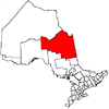 | |
|---|---|---|
| Towns | ||
| Townships | ||
| First Nations | ||
| Indian reserves | ||
| Indian settlements | ||
| Unorganized territories | ||
| Local services boards | ||
| Unincorporated communities |
| |
| ||
This article is issued from
Wikipedia.
The text is licensed under Creative Commons - Attribution - Sharealike.
Additional terms may apply for the media files.