Fraserdale
| Fraserdale | |
| Settlement | |
 | |
| Name origin: Named for Alan Fraser, railway engineer | |
| Country | Canada |
|---|---|
| Province | Ontario |
| District | Cochrane |
| Municipality | Unorganized Cochrane, North Part |
| Elevation | 229 m (751 ft) |
| Coordinates | 49°50′44″N 81°37′01″W / 49.84556°N 81.61694°WCoordinates: 49°50′44″N 81°37′01″W / 49.84556°N 81.61694°W |
| Timezone | Eastern Time Zone (UTC-5) |
| - summer (DST) | Eastern Time Zone (UTC-4) |
 Location of Fraserdale in Ontario. | |
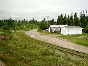
Fraserdale is an unincorporated place and railway point in Unorganized Cochrane, North Part in Cochrane District, Northern Ontario, Canada. It is located 131 kilometres (81 mi) north of Timmins along the Ontario Northland Railway. The community/train stop was named for Alan Fraser, a railway engineer, and is counted as part of Unorganized Cochrane, North Part in Canadian census data.
The neighbouring community Abitibi Canyon (4.5 km or 2.8 mi east) on the Abitibi River was the most extensive community ever built by the Ontario Hydro Electric Power Commission. It was home to 1500 residents and was established to house employees of Abitibi Canyon Generating Station.
Fraserdale is connected to Smooth Rock Falls on Ontario Highway 11 to the south and to Abitibi Canyon to the northeast via Ontario Highway 634.
References
- "Fraserdale". Geographical Names Data Base. Natural Resources Canada. Retrieved 2010-07-01.
- "Toporama - Topographic Map Sheet 42H13". Atlas of Canada. Natural Resources Canada. Archived from the original on 2010-08-31. Retrieved 2010-07-01.
External links
| City | 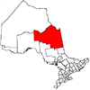 | |
|---|---|---|
| Towns | ||
| Townships | ||
| First Nations | ||
| Indian reserves | ||
| Indian settlements | ||
| Unorganized territories | ||
| Local services boards | ||
| Unincorporated communities |
| |
| ||