Coppell, Ontario
| Coppell | |
|---|---|
|
dispersed rural community Unincorporated area | |
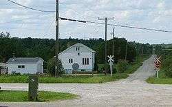 Coppell and the Algoma Central Railway | |
 Coppell Location in Ontario | |
| Coordinates: 49°32′10″N 83°49′45″W / 49.53611°N 83.82917°WCoordinates: 49°32′10″N 83°49′45″W / 49.53611°N 83.82917°W[1] | |
| Country | Canada |
| Province | Ontario |
| District | Cochrane |
| Geographic Township | Lowther |
| Elevation[2] | 280 m (920 ft) |
| Time zone | UTC-5 (Eastern Time Zone) |
| • Summer (DST) | UTC-4 (Eastern Time Zone) |
| Postal Code | P0L |
| Area code(s) | 705, 249 |
Coppell is a dispersed rural community and unincorporated place in geographic Lowther Township,[3] Cochrane District in Northeastern Ontario, Canada.[1] It is about 22 kilometres (14 mi) southwest of Hearst, and is counted as part of Unorganized Cochrane North Part in Canadian census data.
The community is located on Ontario Highway 583 and the Algoma Central Railway, in both cases between the communities of Mead to the south and Jogues to the north.
References
- 1 2 "Coppell". Geographical Names Data Base. Natural Resources Canada. Retrieved 2014-08-29.
- ↑ Taken from Google Earth at geographic coordinates, accessed 2014-08-29.
- ↑ "Lowther" (PDF). Geology Ontario - Historic Claim Maps. Ontario Ministry of Northern Development, Mines and Forestry. Archived from the original (PDF) on 2014-09-03. Retrieved 2014-08-29.
Other map sources:
- Map 14 (PDF) (Map). 1 : 1,600,000. Official road map of Ontario. Ministry of Transportation of Ontario. 2010-01-01. Retrieved 2014-08-29.
- Restructured municipalities - Ontario map #3 (Map). Restructuring Maps of Ontario. Ontario Ministry of Municipal Affairs and Housing. 2006. Retrieved 2014-08-29.
| City | 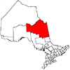 | |
|---|---|---|
| Towns | ||
| Townships | ||
| First Nations | ||
| Indian reserves | ||
| Indian settlements | ||
| Unorganized territories | ||
| Local services boards | ||
| Unincorporated communities |
| |
| ||
This article is issued from
Wikipedia.
The text is licensed under Creative Commons - Attribution - Sharealike.
Additional terms may apply for the media files.