Marmion Avenue
| Marmion Avenue Western Australia | |
|---|---|
 | |
| General information | |
| Type | Highway |
| Length | 40.4 km (25 mi)[1] |
| Opened | 1960s |
| Route number(s) |
|
| Major junctions | |
| South end |
|
| |
| North end | Yanchep Beach Road, Yanchep |
| Location(s) | |
| Major suburbs | Karrinyup, Hillarys, Clarkson, Butler, Alkimos, Yanchep |
| Highway system | |
Marmion Avenue is a 40 kilometre arterial road in the northern coastal suburbs of Perth, Western Australia, linking Trigg in the south with Yanchep in the north. It forms part of State Route 71 along with West Coast Highway, which it joins onto at its southern terminus.
Route Description
Marmion Avenue is part of state route 71, from the southern terminus to Hester Avenue, continuing on from West Coast Highway. It commences in Trigg, traveling generally parallel with the Indian Ocean coastline, and the other north-south arterials Mitchell Freeway and Wanneroo Road, through mostly residential areas and a bit of undeveloped land north of Currambine, and terminates in Yanchep. Marmion Avenue is managed by Main Roads Western Australia from the southern terminus to Ocean Reef Road, the City of Joondalup from Ocean Reef Road to the City of Joondalup Boundary, and the City of Wanneroo for the whole section within the City of Wanneroo.[2][3]
It a four-lane dual carriageway from Trigg to Lukin Drive in Butler, a two-lane dual carriageway from Lukin Drive to Cambourne Parkway, and a two-lane single carriageway from Cambourne Parkway to the terminus in Yanchep.[4] The speed limit is mostly 80 km/h, with a brief 70 km/h sections near the southern terminus in Karrinyup and through Butler, and a 60 km/h section near the northern terminus in Yanchep.[5]
Trigg to Currambine
Marmion Avenue starts as a four-lane dual carriageway as a continuation of West Coast Highway, at the traffic light controlled intersection with Karrinyup Road in the City of Stirling. From there, Marmion Avenue travels north for 1.8 kilometres (1.1 mi), past the Hamersley Public Golf Course and the residential areas of Trigg, North Beach and Karrinyup, before intersecting with the western terminus of Reid Highway and the western section of North Beach Road. Then, Marmion Avenue travels for 1.5 kilometres (0.93 mi) past the Star Swamp Reserve to the west and the residential area of Carine to the west, before intersecting with Beach Road, and crossing over into the City of Joondalup
Marmion Avenue then travels north through redidential suburbs for 6.6 kilometres (4.1 mi), having traffic light controlled intersections with Warwick Road and Hepburn Avenue, before passing Westfield Whitford City shopping centre, near Whitfords Avenue. Marmion Avenue continues north through residential areas, intersecting with Ocean Reef Road, Hodges Drive, Shenton Avenue and Moore Drive, and passing by Currambine Central Shopping Centre, before intersecting with Burns Beach Road.[4]
North of Currambine
North of Burns Beach Road, Marmion Avenue passes through 1.9 kilometres (1.2 mi) of residential areas, before crossing into the City of Wanneroo and travelling through 1.6 kilometres (0.99 mi) of undeveloped land in Tamala Park. Marmion Avenue provides access to the Tamala Park Rubbish Disposal Site. Marmion Avenue then travels through the Clarkson – Butler region for 9.6 kilometres (6.0 mi), intersecting with Neerabup Road, Hester Avenue and Lukin Drive. Marmion Avenue loses the State Route 71 allocation at the intersection with Hester Avenue, and becomes a 2 lane road at Lukin Drive.
Marmion Avenue then travels northwards, through the soon to be developed suburbs of Alkimos and Eglinton, providing access to current and future developments. After 8 kilometres (5.0 mi), Marmion Avenue reaches the outer suburb of Yanchep, and terminates at a large roundabout with Yanchep Beach Road.[4]
History

Marmion Avenue was first built as an arterial road that tracked the then-new outer northern suburbs of Perth, following the limit of the Perth metropolitan area as it expanded northwards. In the late 1960s, the road originally began at Beach Road in Marmion, giving the road its namesake.
Until the early 1980s, the road was a two-lane single carriageway connecting the coastal suburbs of Marmion and Mullaloo Beach. In 1984-85, the road was extended southwards to Karrinyup Road where it joined seamlessly onto West Coast Highway, which had been realigned further inland around the same time. Now the most important road in Perth's coastal suburbs, Marmion Avenue was duplicated up to Whitfords Avenue. In early 1986, it was assigned State Route 71, and from then on was gradually extended as a single carriageway road further north - extending first to Prendiville Avenue (just north of Ocean Reef Road), to Burns Beach Road in 1991 and to Quinns Road in the mid-1990s. Marmion Avenue was finally duplicated to its terminus in 2001, with the last portion being the empty stretch between Burns Beach Road & Quinns Rocks.
In 2000 and 2001, Reid Highway was extended as a two lane road from its terminus at Mitchell Freeway to Marmion Avenue, providing another link to the east.[6] This section was later upgraded to a four-lane dual carriageway in 2015-2016.[7]
After delays due to disagreements at State Government level about what route the road should follow, Marmion Avenue was extended further north to Yanchep and opened to traffic in November 2008. The extension is currently a single carriageway, but earthworks have already been undertaken to enable conversion to dual carriageway at a later date. The extension also features roundabouts at future major junctions. The completion of this extension allowed the future satellite city of Alkimos/Eglinton to begin construction.[8][9]
On July 1, 2010, fixed red light and speed cameras were installed at the Marmion Avenue / Hepburn Avenue intersection to fine people who run red lights and speed, so the amount of road deaths in Western Australia can be reduced.[10][11]
In 2016, the existing Marmion Avenue / Mullaloo Drive intersection was upgraded from a non-signalised t-junction to a roundabout in response to a ranking as the 39th Worst Intersection. Pedestrian paths were re-aligned, off-road cycling paths were added, Western Power light poles were upgraded and crash barriers were installed to protect residents and pedestrians.[12][13]
As part of Main Roads Western Australia's Traffic Congestion Management Program, Marmion Avenue's intersections with Hepburn Avenue and Whitfords Avenue were upgraded during 2016 and 2017 to improve traffic flow and safety. Between 2010 and 2015, there were 249 crashes at both of these intersections combined, and 72,000 vehicle use both these intersections per day. This project was funded by the state government, and cost $12 million. Longer and additional turning lanes were added, pedestrian and cycling facilities were upgraded, traffic signals were upgraded and power lines were put underground. CCTV was also installed so that Main Roads can monitor traffic flow. Construction started in November 2016 and finished ahead of schedule in May 2017.[14][15][16][17][18]
Future
Works are currently in progress to widen Marmion Avenue to a four-lane dual carriageway between Lukin Drive and Butler Boulevard. The project costs $2.21 million and is funded by the City of Wanneroo. Construction started in February 2017 and is expected to be complete by August 2017.[19][20]
Construction is planned to start in 2018 on upgrading Marmion Avenue north of Camborne Parkway, from the current 2-lane single carriageway to a 4-lane dual carriageway. The state government is giving the City of Wanneroo $23 million to upgrade the road, and it is scheduled to be complete by 2020.[21][22][23]
Extensions of Marmion Avenue are possible to Two Rocks. However, there are no plans for this at present. Perth's Transport at 3.5 million plan does not say that Marmion Avenue will be extended,[24] and the Department of Planning's documents currently show Marmion Avenue terminating at Yanchep.[25] One possible complication would be Two Rocks's past use as a munitions dump, meaning that most non-suburban sections of the suburb are fenced off.
The ultimate plan is for Marmion Avenue to become a six-lane dual carriageway between Alkimos and Yanchep, and a four-lane dual carriageway for the rest of the road. Also, the intersection with Yanchep Beach Road may be grade separated by 2050.[24]
Junction List
| LGA[5] | Location[5] | km | mi | Destinations | Notes |
|---|---|---|---|---|---|
| Stirling | Trigg–Karrinyup boundary | 0.0 | 0.0 | Marmion Avenue terminus; Road continues south as West Coast Highway; Traffic light controlled intersection | |
| North Beach–Watermans Bay–Carine–Karrinyup quadripoint | 1.8 | 1.1 | Traffic light controlled intersection | ||
| Stirling–Joondalup boundary | Marmion-Duncraig–Carine tripoint | 3.4 | 2.1 | Beach Road | Traffic light controlled t-junction |
| Joondalup | Marmion–Sorrento–Duncraig tripoint | 4.6 | 2.9 | Traffic light controlled t-junction | |
| Sorrento–Hillarys–Padbury–Duncraig quadripoint | 6.7 | 4.2 | Traffic light controlled intersection; fixed red light and speed cameras installed[10] | ||
| Hillarys–Kallaroo–Craigie–Padbury quadripoint | 9.2 | 5.7 | Traffic light controlled intersection | ||
| Mullaloo–Beldon boundary | 11.0 | 6.8 | Mullaloo Drive – Mullaloo | Roundabout t-junction | |
| Mullaloo–Ocean Reef–Heathridge–Beldon quadripoint | 12.1 | 7.5 | Traffic light controlled intersection | ||
| Ocean Reef–Connolly–Heathridge | 14.1 | 8.8 | Hodges Drive – Heathridge, Joondalup | Traffic light controlled intersection | |
| Ocean Reef–Iluka–Currambine–Connolly quadripoint | 15.5 | 9.6 | Shenton Avenue – Connolly, Joondalup | Roundabout intersection | |
| Iluka–Currambine boundary | 16.6 | 10.3 | Moore Drive – Currambine, Joondalup | T-junction | |
| Iluka–Burns Beach–Kinross–Currambine quadripoint | 17.4 | 10.8 | Traffic light controlled intersection | ||
| Wanneroo | Mindarie–Clarkson tripoint | 21.5 | 13.4 | Anchorage Drive west / Neerabup Road east – Mindarie, Clarkson | Roundabout intersection |
| Mindarie–Merriwa–Clarkson tripoint | 23.6 | 14.7 | Anchorage Drive North west / Hester Avenue east – Mindarie, Merriwa, Ridgewood, Clarkson | State route 71 northern terminus; Roundabout intersection | |
| Quinns Rocks–Butler–Merriwa tripoint | 25.9 | 16.1 | Lukin Drive – Butler, Ridgewood, Merriwa | Roundabout t-junction | |
| Jindalee–Butler boundary | 27.0 | 16.8 | Jindalee Boulevard west / Kingsbridge Boulevard east – Jindalee, Butler | Traffic light controlled intersection | |
| Jindalee–Butler boundary | 28.8 | 17.9 | Reflection Boulevard west / Cambourne Parkway east – Jindalee, Butler | Traffic light controlled intersection | |
| Yanchep | 40.0 | 24.9 | Lagoon Drive west / Peony Boulevard east – Yanchep | Traffic light controlled intersection | |
| 40.4 | 25.1 | Yanchep Beach Road – Yanchep, Two Rocks | Marmion Avenue terminus; Roundabout t-junction | ||
| |||||
Gallery
| Wikimedia Commons has media related to Marmion Avenue. |
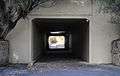 An underpass below Marmion Avenue, near Whitfords Avenue
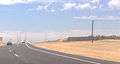 New, single-lane extension of Marmion Avenue opened in 2008, heading north in the currently undeveloped suburb of Alkimos
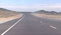 New, single-lane extension of Marmion Avenue opened in 2008, heading north in the currently undeveloped suburb of Eglinton
References
- ↑ "Google Maps". Google. Retrieved 24 June 2017.
- ↑ "Metropolitan Roads Controlled by Main Roads Western Australia". Main Roads Western Australia. Retrieved 25 June 2017.
- ↑ "Main Roads Survey Portal". Main Roads Western Australia. Retrieved 25 June 2017.
- 1 2 3 "Google Maps". Google. Retrieved 24 June 2017.
- 1 2 3 "Road Information Mapping System". Main Roads Western Australia. Retrieved 24 June 2017.
- ↑ "Work on Reid Highway extension to start soon". Media Statements. Retrieved 25 June 2017.
- ↑ "Reid Highway Widening - Duffy Road to Marmion Avenue". Main Roads Western Australia. Retrieved 25 June 2017.
- ↑ "Skyview WA". Land Online. Department of Land Information, Western Australia.
- ↑ "Marmion Avenue Extension". RJ Vincent & Co. Archived from the original on 19 July 2008. Retrieved 25 April 2012.
- 1 2 "Camera Locations". Western Australia Police. Retrieved 25 June 2017.
- ↑ "Dual speed and red light cameras for Perth". WA today. Retrieved 25 June 2017.
- ↑ "Marmion Ave And Mullaloo Drive Upgrade". Smart Transport. Retrieved 24 June 2017.
- ↑ "Marmion Avenue / Mullaloo Drive Intersection Upgrade". Main Roads Western Australia. Retrieved 24 June 2017.
- ↑ "$12 million upgrade for Marmion Ave intersections". Media Statements. Government of Western Australia. Retrieved 24 June 2017.
- ↑ "$7.4m Marmion Avenue upgrade to commence". Media Statements. Government of Western Australia. Retrieved 24 June 2017.
- ↑ "Busy Marmion Avenue intersection upgrades completed early". Media Statements. Government of Western Australia. Retrieved 24 June 2017.
- ↑ "Marmion Avenue Intersection Upgrades Newsletter" (PDF). Main Roads Western Australia. Retrieved 24 June 2017.
- ↑ "Marmion Avenue Intersection Upgrades". Main Roads Western Australia. Retrieved 24 June 2017.
- ↑ "Construction company RJ Vincent & Co wins contract to widen Marmion Avenue". Community News. Retrieved 24 June 2017.
- ↑ "Marmion Avenue dual carriageway from Lukin Drive to Butler Boulevard". City of Wanneroo. Retrieved 24 June 2017.
- ↑ "Marmion Avenue to be widened to Yanchep". Media Statements. Government of Western Australia. Retrieved 10 August 2017.
- ↑ "State Government announces $23 million to widen Marmion Avenue to Yanchep". North Coast Times. Community News. 6 August 2017. Retrieved 10 August 2017.
- ↑ Barry, Hannah (6 August 2017). "Single lane road between Butler and Yanchep to be upgraded to four lanes". WA Today. Retrieved 10 August 2017.
- 1 2 "Road Network Plan" (PDF). Main Roads Western Australia. Retrieved 24 June 2017.
- ↑ "MRS Two Rocks" (PDF). Department of Planning. Retrieved 22 June 2017.
See also
- West Coast Highway, Perth
- List of major roads in Perth, Western Australia
| |||
| National Highways | |||
| National Routes | |||
| State Routes | |||
| Tourist Drives | |||