Canonica d'Adda
| Canonica d'Adda | ||
|---|---|---|
| Comune | ||
| Comune di Canonica d'Adda | ||
.jpg) Canonica from across the Adda | ||
| ||
 Canonica d'Adda Location of Canonica d'Adda in Italy | ||
| Coordinates: 45°35′N 9°32′E / 45.583°N 9.533°ECoordinates: 45°35′N 9°32′E / 45.583°N 9.533°E | ||
| Country | Italy | |
| Region | Lombardy | |
| Province | Bergamo (BG) | |
| Government | ||
| • Mayor | Graziano Pirotta | |
| Area | ||
| • Total | 3.2 km2 (1.2 sq mi) | |
| Elevation | 99 m (325 ft) | |
| Population (Dec. 2004)[1] | ||
| • Total | 3,944 | |
| • Density | 1,200/km2 (3,200/sq mi) | |
| Time zone | UTC+1 (CET) | |
| • Summer (DST) | UTC+2 (CEST) | |
| Postal code | 24040 | |
| Dialing code | 02 | |
| Patron saint | Santa Maria Assunta | |
| Saint day | August 15 | |
| Website | Official website | |
Canonica d'Adda (Bergamasque: Calònega; Milanese: Canòniga) is a comune (municipality) in the Province of Bergamo in the Italian region of Lombardy, located about 30 kilometres (19 mi) northeast of Milan and about 15 kilometres (9 mi) southwest of Bergamo.
It lies on the left bank of the river Adda which separates it from Vaprio d'Adda and is here the boundary between the Province of Bergamo and the Province of Milan. Canonica d'Adda also borders the municipalities of Brembate, Capriate San Gervasio, Fara Gera d'Adda and Pontirolo Nuovo.
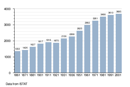
Demographic evolution
Gallery
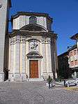
Parish church .jpg)
The Adda runs between Canonica d’Adda (on our right) and Vaprio d’Adda.
References
External links
| Wikimedia Commons has media related to Canonica d'Adda. |

| Authority control |
|---|
This article is issued from
Wikipedia.
The text is licensed under Creative Commons - Attribution - Sharealike.
Additional terms may apply for the media files.