Bridgeman Island (South Shetland Islands)
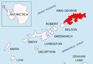 Location of King George Island in the South Shetland Islands | |
 Bridgeman Island Location of Bridgeman Island  Bridgeman Island Bridgeman Island (Antarctica) | |
| Geography | |
|---|---|
| Location | Antarctica |
| Coordinates | 62°04′S 56°44′W / 62.067°S 56.733°WCoordinates: 62°04′S 56°44′W / 62.067°S 56.733°W |
| Archipelago | South Shetland Islands |
| Length | 0.8 km (0.5 mi) |
| Highest elevation | 240 m (790 ft) |
| Administration | |
| Administered under the Antarctic Treaty System | |
| Demographics | |
| Population | Uninhabited (although there are some weather stations) |
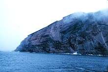
Bridgeman Island or Bridgemans's Island or Bridgman Island or Helena Island is one of the South Shetland Islands. It is an almost circular, volcanic island marked by steep sides, 0.8 kilometres (0.5 mi) long and 240 m (787 ft) high, lying 37 kilometres (23 mi) east of King George Island (South Shetland Islands). Bridgeman Island is located at 62°04′S 56°44′W / 62.067°S 56.733°W and has an elevation of 240 m (787 ft). Bridgeman Island is an established name dating back to about 1820. Bridgeman Island is the remnants of a much larger volcanic edifice that is now largely submerged. The eroded volcano does not display youthful volcanic features. Several reports of 19th-century fumarolic activity may instead refer to the much younger Penguin Island.
See also
References
- "Bridgeman Island". Global Volcanism Program. Smithsonian Institution.
- LeMasurier, W. E.; Thomson, J. W., eds. (1990). Volcanoes of the Antarctic Plate and Southern Oceans. American Geophysical Union. p. 512 pp. ISBN 0-87590-172-7.
External links
- Website with a picture of Bridgeman Island
- Website with another picture of Bridgeman island, in Spanish.
| General |
| .svg.png) |
|---|---|---|
| Geographic regions | ||
| Waterways | ||
| Famous explorers | ||