Monongahela National Forest
| Monongahela National Forest | |
| U.S. National Forest | |
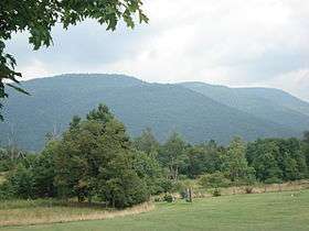
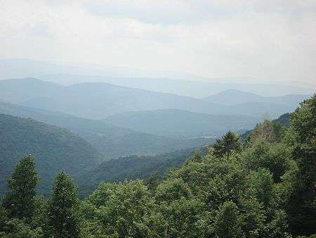 View from the slopes of Back Allegheny Mountain looking east. Visible are Allegheny Mountain (middle distance) and Shenandoah Mountain (far distance). The latter is in the George Washington National Forest of Virginia | |
| Name origin: Monongahela River, in whose watershed much of the original forest was located | |
| Country | United States |
|---|---|
| State | West Virginia |
| Counties[1] | Grant, Greenbrier, Nicholas, Pendleton, Pocahontas, Preston, Randolph, Tucker, Webster |
| Ranger Districts[1] | Cheat-Potomac, Greenbrier, Marlinton-White Sulphur Springs, Gauley |
| Coordinates | 38°55′45″N 79°50′52″W / 38.92917°N 79.84778°WCoordinates: 38°55′45″N 79°50′52″W / 38.92917°N 79.84778°W |
| Highest point | Spruce Knob |
| - location | Pendleton County, WV |
| - elevation | 4,863 ft (1,482.2 m) |
| - coordinates | 38°41′59″N 79°31′58″W / 38.69972°N 79.53278°W |
| Lowest point | South Branch Potomac River |
| - location | west of Petersburg, WV |
| - elevation | 968 ft (295.0 m) |
| - coordinates | 39°00′05″N 79°09′46″W / 39.00139°N 79.16278°W |
| Area | 921,150 acres (372,776 ha) [2] |
| - Proclamation Boundary | 1,706,898 acres (690,757 ha) [2] |
| Established | April 28, 1920 |
| - Monongahela Purchase | 1915 |
| Owner | US Forest Service |
| Headquarters | Elkins, West Virginia |
 Location of Monongahela National Forest | |
| Wikimedia Commons: Monongahela National Forest | |
| Website: Monongahela National Forest | |
The Monongahela National Forest is a national forest located in the Allegheny Mountains of eastern West Virginia, USA. It protects over 921,000 acres (3,727 km2; 1,439 sq mi) of federally owned land within a 1,700,000 acres (6,880 km2; 2,656 sq mi) proclamation boundary that includes much of the Potomac Highlands Region and portions of 10 counties.[3]
The Monongahela National Forest includes some major landform features such as the Allegheny Front and the western portion of the Ridge-and-valley Appalachians. Within the forest are most of the highest mountain peaks in the state, including the highest, Spruce Knob (4,863 ft), also the highest point in the Alleghenies. Approximately 75 tree species are found in the forest. Almost all of the trees are a second growth forest, grown back after the land was heavily cutover around the start of the 20th century. Species for which the forest is important include red spruce (Picea rubens), balsam fir (Abies balsamea), and mountain ash (Sorbus americana).
The Monongahela National Forest includes eight U.S. Wilderness Areas and several special-use areas, notably the Spruce Knob-Seneca Rocks National Recreation Area.
Administration
The forest is administered from the main headquarters in Elkins, West Virginia, and four ranger districts. The forest has approximately 105 permanent employees, with this force augmented by senior citizens, temporary employees, and volunteers.
Ranger Districts
Monongahela National Forest is currently divided into four ranger districts.[1] The Cheat-Potomac and Marlinton-White Sulphur Springs were formed by combining their namesake districts; in the merged districts, the offices for both original districts were retained.
- Cheat-Potomac Ranger District, Headquarters: Parsons, West Virginia
- Office (former HQ, Potomac Ranger District) at Petersburg, West Virginia
- Gauley Ranger District, Headquarters: Richwood, West Virginia
- Greenbrier Ranger District, Headquarters: Bartow, West Virginia
- Marlinton-White Sulphur Springs Ranger District, Headquarters: Marlinton, West Virginia
- Office (former HQ, White Sulphur Springs Ranger District) at White Sulphur Springs, West Virginia
History
The Monongahela National Forest was established following passage of the Weeks Act in 1911. This act authorized the purchase of land for long-term watershed protection and natural resource management following the massive cutting of the eastern forests in the late 19th and early 20th centuries. In 1915, 7,200 acres (29 km2) were acquired to begin the forest, called the "Monongahela Purchase", and on April 28, 1920 it became the "Monongahela National Forest". By the end of 1924, the Monongahela National Forest had a total ownership of some 150,367 acres (609 km2).
Although white-tail deer never became completely extirpated from the Monongahela National Forest, from the 1890s to the 1920s their numbers throughout the state (as with most of the eastern US) were being officially reported as "almost zero". In January 1930, eight deer procured from Michigan were released into the forest near Parsons. From 1937 to 1939, a total of 17 more deer were released in the Flatrock-Roaring Plains area of the Forest.[4][5] These releases served as the nucleus for reestablishing the healthy breeding populations of eastern West Virginia. (By the mid-1940s, deer were so numerous in the area that crop farmers had to patrol their fields by night.[6])
In 1943 and 1944, as part of the West Virginia Maneuver Area, the U.S. Army used parts of the Monongahela National Forest as a practice artillery and mortar range and maneuver area before troops were sent to Europe to fight in World War II. Artillery and mortar shells shot into the area for practice are still occasionally found there today. Seneca Rocks and other area cliffs were also used for assault climbing instruction. This was the Army's only low-altitude climbing school.
The fisher (Martes pennanti), believed to have been exterminated in the state by 1912, was reintroduced during the winter of 1969. At that time 23 fishers were translocated from New Hampshire to two sites within boundaries of the Monongahela National Forest (at Canaan Mountain in Tucker County and Cranberry Glades in Pocahontas County).
In 1980, and again in 2005, the Monongahela National Forest was the venue for the annual counterculture Rainbow Gathering.[7]
In 1993, the Craig Run East Fork Rockshelter and Laurel Run Rockshelter in the Gauley Ranger District were listed on the National Register of Historic Places.[8]
Statistics and general information
General
- Land area: over 919,000 acres (3,719 km2)[3]
- Wilderness areas: 94,991 acres (384 km2)[9][10][11][12][13][14][15]
- Roads: 570 miles (920 km)
- Visitor centers: 2 (Cranberry Mountain Nature Center and Seneca Rocks Discovery Center)
- Designated Scenic Areas: 3
- Visitor observation towers: 2 (Bickle Knob Tower and Olson Tower)
- Picnic areas: 17
- Campgrounds: 23
- Snowmobile areas: 1 (Highland Scenic Highway)
- Wildlife management areas (managed with West Virginia Division of Natural Resources): 10
- Warm-water fishing steams: 129 miles (208 km)
- Trout streams: 578 miles (930 km)
- Impoundments (reservoirs): 5
Trails
- Trails: 825 miles (1,327 km)
- Outside Wilderness Areas: 660 miles (1,062 km), not counting the 3 newest wildernesses
- In Wilderness Areas: 165 miles (265 km), not counting the 3 newest wildernesses
Natural features
- Wilderness areas: 8
Sensitive species
- Sensitive plants and wildlife: 50
- Threatened and endangered species: 9
Geography
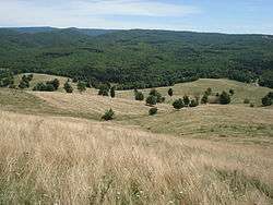
The Monongahela National Forest encompasses most of the southern third of the Allegheny Mountains range (a section of the vast Appalachian Mountains range) and is entirely within the state of West Virginia. Elevations within the Monongahela National Forest range from about 900 feet (270 m) at Petersburg to 4,863 feet (1,482 m) at Spruce Knob. A rain shadow effect caused by slopes of the Allegheny Front results in 60 inches (1,500 mm) of annual precipitation on the west side and about half that on the east side.
Headwaters of six major river systems are located within the forest: Monongahela, Potomac, Greenbrier, Elk, Tygart, and Gauley. Twelve rivers are currently under study for possible inclusion in the National Wild and Scenic Rivers System.
Ecology
The forest is noted for its rugged landscape, views, blueberry thickets, highland bogs and "sods", and open areas with exposed rocks. In addition to the second-growth forest trees, the wide range of botanical species found includes rhododendron, laurel on the moist west side of the Allegheny Front, and cactus and endemic shale barren species on the drier eastern slopes.
There are 230 known species of birds inhabiting the Monongahela National Forest: 159 are known to breed there, 89 are Neotropical migrants; 71 transit the forest during migration, but do not breed there, and 17 non-breeding species are Neotropical. The Brooks Bird Club (BBC) conducts an annual bird banding and survey project in the vicinity of Dolly Sods Scenic Area during migration (August - September). The forest provides habitat for 9 federally listed endangered or threatened species: 2 bird species, 2 bat species, 1 subspecies of flying squirrel, 1 salamander species, and 3 plant species. Fifty other species of rare/sensitive plants and animals also occur in the forest.
Larger animals and game species found in the forest include black bear, wild turkey, white-tailed deer, gray and fox squirrels, rabbits, snowshoe hare, woodcock, and grouse. Limited waterfowl habitat exists in certain places. Furbearers include beaver, red and gray fox, bobcat, fisher, river otter, raccoon and mink. Other hunted species include coyotes, skunks, opossums, woodchucks, crows, and weasels. There are 12 species of game (pan) fish and 60 species of nongame or forage fish. Some 90% of the trout waters of West Virginia are within the forest.
Recreation
The Monongahela National Forest is a recreation destination and tourist attraction, hosting approximately 3 million visitors annually. The backwoods road and trail system is used for hiking, mountain biking, horse riding. There are many miles of railroad grades that are a link in the recreation use of the forest. (The longest is the Glady to Durbin West Fork Railroad Trail which is 23 miles (37 km) long.) Recreation ranges from self-reliant treks in the wildernesses and backcountry areas, to the challenges of mountain climbing, to traditional developed site camping. Canoeing, hunting, trapping, fishing, and wildlife viewing are also common uses.
Campgrounds
The following is a list of campgrounds in the forest:[16]
|
|
|
Commercial resources
The forest administration maintains wildlife and timber programs aimed at managing a mix of tree species and ages. About 81 percent of the total forest area is closed canopy forest over 60 years of age. The tree species most valuable for timber and for wildlife food in the Monongahela National Forest are black cherry and oaks. The forest's commercial timber sale program averages 30 mbf (million board feet) of timber sold per year with a yearly average value of $7.5 million. A variety of cutting techniques are used, from cutting of single trees to clearcutting blocks up to 25 acres (100,000 m2) in size. Regeneration cuts (clearcuts or other treatments designed to start a new timber stand) occur on approximately 1,300 acres (5.3 km2) yearly out of the more than 909,000 acres (3,680 km2) forest total.
Mineral resources located in the Monongahela National Forest include coal, gas, limestone, and gravel; but not oil. Sheep and cattle grazing occurs on about 7,000 acres (28 km2).
Receipts for timber, grazing, land uses, minerals, and recreation use averaged $4,840,466 annually between FY92 and FY96, and 25% of that (an average of $1,210,116 per year) was returned to counties that include Monongahela National Forest lands. This money is intended for use by local schools and for roads. The remaining 75% each year is returned to the U.S. Treasury.
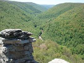
Areas of interest within the Monongahela National Forest

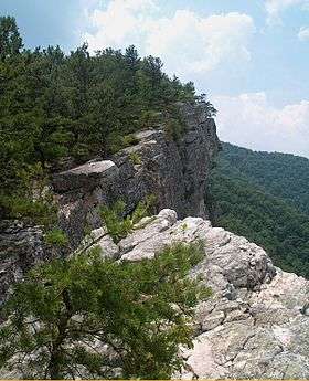
Spruce Knob-Seneca Rocks National Recreation Area
- Spruce Knob
- Seneca Rocks
- River Knobs
- Spruce Knobs lake
- Sites Homestead
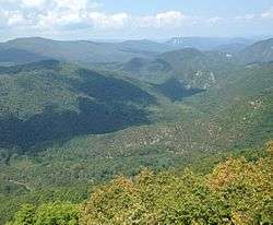
- Smoke Hole Canyon
U.S. Wilderness Areas
- Big Draft Wilderness, 5,144 acres (21 km2)[9]
- Cranberry Wilderness, 47,815 acres (194 km2)[10]
- Dolly Sods Wilderness, 17,371 acres (70 km2)[11]
- Laurel Fork North Wilderness, 6,055 acres (25 km2)[12]
- Laurel Fork South Wilderness, 5,784 acres (23 km2)[12]
- Otter Creek Wilderness, 20,698 acres (84 km2)[13]
- Roaring Plains West Wilderness, 6,792 acres (27 km2)[14]
- Spice Run Wilderness, 6,030 acres (24 km2)[15]
Registered National Natural Landmarks
- Big Run Bog
- Blister Run Swamp
- Canaan Valley
- Cranberry Glades Botanical Area
- Fisher Spring Run Bog
- Gaudineer Scenic Area
- Germany Valley Karst Area
- Shavers Mountain Spruce-Hemlock Stand
- Sinnett-Thorn Mountain Cave System
Sites listed on the National Register of Historic Places
- NB: Only sites actually on USFS land are listed here.
Stands of old growth forest
Some 318 acres (1.29 km2) of true old-growth forest have been documented within the Monongahela National Forest.[17] The largest of these areas are:
- Fanny Bennett Hemlock Grove, a 70-acre (280,000 m2) eastern hemlock stand
- Gaudineer Scenic Area, 50 acres of virgin red spruce forest
- North Fork Mountain Red Pine Botanical Area, 10 acres of red pine old growth forest
- North Spruce Mountain Old Growth Site, about 17 acres (69,000 m2)
- Shavers Mountain Spruce-Hemlock Stand, a 68-acre (280,000 m2) red spruce-hemlock stand, partly in the Otter Creek Wilderness
- Virgin White Pine Botanical Area, a 13-acre (53,000 m2) white pine stand
Other features
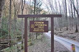
- Fernow Experimental Forest
- Lake Sherwood
- Summit Lake
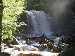
- Falls of Hills Creek
- Highland Scenic Highway
- Williams River
- Stuart Memorial Drive
- Flatrock Plains
- Sinks of Gandy Creek
Gallery

 North Fork Mountain
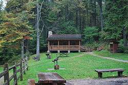 Middle Mountain Cabins
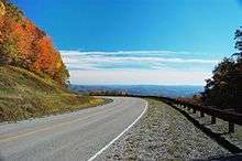
.jpg)


 Smoke Hole Canyon from atop Cave Mountain
 Fanny Bennett Hemlock Grove
See also
- High Allegheny National Park and Preserve, a proposed National Park Service unit that would have encompassed the northern part of Monongahela National Forest
References
Citations
- 1 2 3 "Monongahela National Forest: Land and Resource Management Plan". Monongahela National Forest. September 2006. Archived from the original (PDF) on 2009-01-19. Retrieved 2009-01-19.
- 1 2 "Land Areas of the National Forest System" (PDF). U.S. Forest Service. January 2012. Retrieved June 30, 2012.
- 1 2 "About the Forest". Monongahela National Forest. Retrieved April 13, 2010.
- ↑ DeGarmo, W. R. (1949), A White-tailed Deer Study; Final Report, W-8-R, Phase B, Statewide Wildlife Survey, West Virginia Conservation Commission, Charleston, West Virginia, 184pp.
- ↑ Lesser, Walter A. and Jack I. Cromer Unpublished MS: Historical Review of Wildlife Management in Canaan Valley and Surrounding Area, West Virginia Division of Natural Resources, pg 2.
- ↑ DeGarmo, W.R., and J. Gill (1958), West Virginia White-tails, Conservation Commission of West Virginia, Charleston, West Virginia, 87 pp.
- ↑ "Rainbow Gathering". West Virginia Encyclopedia. West Virginia Humanities Council. Retrieved August 17, 2017.
- ↑ National Park Service (2010-07-09). "National Register Information System". National Register of Historic Places. National Park Service.
- 1 2 "Big Draft Wilderness". Monongahela National Forest. Retrieved April 13, 2010.
- 1 2 "Cranberry Wilderness". Monongahela National Forest. Retrieved April 13, 2010.
- 1 2 "Dolly Sods Wilderness". Monongahela National Forest. Retrieved April 13, 2010.
- 1 2 3 "Laurel Fork Wilderness brochure" (PDF). Monongahela National Forest. Retrieved April 13, 2010.
- 1 2 "Otter Creek Wilderness". Monongahela National Forest. Retrieved April 13, 2010.
- 1 2 "Roaring Plains West Wilderness". Monongahela National Forest. Retrieved April 13, 2010.
- 1 2 "Spice Run Wilderness". Monongahela National Forest. Retrieved April 13, 2010.
- ↑ Monongahela National Forest Campground Information Index
- ↑ Forest Service, U.S. Department of Agriculture (September 2006), Monongahela National Forest Land and Resource Management Plan; Appendix B, pg 4.
Other sources
- McKim, C.R. (1970), Monongahela National Forest History, Unpublished manuscript available at the Monongahela National Forest Office, Elkins, West Virginia.
- de Hart, Allen and Bruce Sundquist (2006), Monongahela National Forest Hiking Guide, 8th edition, West Virginia Highlands Conservancy, Charleston, West Virginia.
- Berman, Gillian Mace, Melissa Conley-Spencer, Barbara J. Howe and Charlene Lattea (1992), The Monongahela National Forest: 1915-1990, Morgantown, West Virginia: WVU Public History Program; For the United States Forest Service: Monongahela National Forest. (March 1992)
- DeMeo, Tom and Julie Concannon (1996), "On the Mon: Image and Substance in West Virginia's National Forest", Inner Voice, Vol. 8, Issue 1, January/February.
- Weitzman, Sidney (1977), Lessons from the Monongahela Experience, USDA, Forest Service, December.
- This article contains information that originally came from US Government publications and websites and is in the public domain.
External links
| Wikimedia Commons has media related to Monongahela National Forest. |
