Billabong Creek
| Billabong | |
| Moulamein[1] | |
| Creek[1] | |
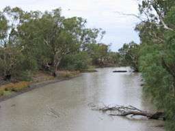 Billabong Creek at Moulamein. | |
| Name origin: Aboriginal: an effluent from a river, sometimes separated from it, sometimes being joined again at time of flood.[1][2] | |
| Country | Australia |
|---|---|
| State | New South Wales |
| Region | Riverina (IBRA) |
| LGA | Federation Council |
| Part of | Murray catchment, Murray-Darling basin |
| Towns | Morven, Culcairn, Walbundrie, Rand, Jerilderie, Conargo, Wanganella, Moulamein |
| Source confluence | Yarra Yarra Creek and Little Billabong Creek |
| - location | near Holbrook |
| - elevation | 322 m (1,056 ft) |
| Mouth | confluence with the Edward River |
| - location | Moulamein |
| - elevation | 70 m (230 ft) |
| - coordinates | 35°5′32″S 144°2′0″E / 35.09222°S 144.03333°ECoordinates: 35°5′32″S 144°2′0″E / 35.09222°S 144.03333°E |
| Length | 320 km (199 mi) |
| Basin | 791 km2 (305 sq mi) |
 Location of the Billabong Creek mouth in New South Wales | |
| Wikimedia Commons: Billabong Creek | |
| [3][4] | |
The Billabong Creek, a partly perennial stream[1] of the Murray River catchment within the Murray-Darling basin, is located in the Riverina region of New South Wales, Australia.
At 320 kilometres (200 mi) (with some estimates ranging up to 596 kilometres (370 mi)[4]), Billabong Creek is believed to be the longest creek in the world.[3]
Course and features
Formed by the confluence of the Yarra Yarra Creek and Little Billabong Creek, Billabong Creek rises on the Great Dividing Range, north of Holbrook, and flows generally west, northwest, and west, joined by sixteen minor tributaries before reaching its confluence with the Edward River, at Moulamein. The creek descends 252 metres (827 ft)[4] over its 320 kilometres (200 mi) course.
From source to mouth, the creek passes through the towns of Morven, Culcairn, Walbundrie, Rand, Jerilderie, Conargo, Wanganella, and Moulamein.
The creek has a catchment area of 791 square kilometres (305 sq mi) and is the main present drainange line between the Murray and the Murrumbidgee rivers.[5] Alluvial deposits from the system fill a long narrow paleovalley that extends for about 150 kilometres (93 mi) from Garryowen (near Holbrook) to Walla Walla.
Gallery
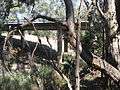 Billabong Creek at Rand.
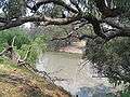 Billabong Creek at Wanganella.
See also
References
- 1 2 3 4 "Billabong Creek". Geographical Names Register (GNR) of NSW. Geographical Names Board of New South Wales. Retrieved 16 June 2013.
- ↑ Reed, A. W. (1973). Place names of Australia. Frenchs Forest, New South Wales: Reed Books. p. 31. ISBN 0-589-50128-3.
- 1 2 "Billabong Creek Salt Interception Scheme". NSW Department of Primary Industries: Office of Water. 2009. Retrieved 16 June 2013.
- 1 2 3 "Map of Billabong Creek, NSW". Bonzle Digital Atlas of Australia. Retrieved 16 June 2013.
- ↑ "Water Resources Overview - New South Wales". ANRA. Government of Australia. 2009. Archived from the original on 21 March 2011. Retrieved 16 October 2010.
External links

- "Murray River catchment (NSW)" (map). Office of Environment and Heritage. Government of New South Wales.
- Map of the Billabong Creek NSW Murray Wetlands Working Group
| Cities | |
|---|---|
| Local government areas | |
| Towns / Communities |
|
| National parks |
|
| Rivers, Water and irrigation entities Other watercourses |
|
| Landmarks | |