Nattai River
| Nattai | |
| River[1] | |
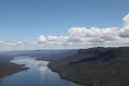 An aerial photograph of the Nattai River to form Lake Burragorang, in 2012. | |
| Country | Australia |
|---|---|
| State | New South Wales |
| Regions | Sydney Basin (IBRA), Southern Highlands |
| LGA | Wollondilly |
| Part of | Hawkesbury-Nepean catchment |
| Tributaries | |
| - left | Wanganderry Creek, Allum River |
| - right | Rocky Waterholes Creek, Martins Creek (Wollondilly), Little River, Gillans Creek |
| Source | Mittagong Range, Great Dividing Range |
| - location | south of Mittagong |
| - elevation | 452 m (1,483 ft) |
| - coordinates | 34°24′48″S 150°26′22″E / 34.41333°S 150.43944°E |
| Mouth | confluence with the Wollondilly River to form Lake Burragorang |
| - location | Nattai |
| - elevation | 116 m (381 ft) |
| - coordinates | 34°5′2″S 150°25′21″E / 34.08389°S 150.42250°ECoordinates: 34°5′2″S 150°25′21″E / 34.08389°S 150.42250°E |
| Length | 51 km (32 mi) |
| National park | Nattai National Park |
| Reservoir | Lake Burragorang |
 Location of the Nattai River mouth in New South Wales | |
| [1][2] | |
The Nattai River, a perennial river[1] that is part of the Hawkesbury-Nepean catchment, is located in the Southern Highlands region of New South Wales, Australia.
Course and features
The Nattai River rises on the Mittagong Range within the Great Dividing Range, south of Mittagong, and flows generally north northwest and then north northeast, joined by nine tributaries including the Little River, before reaching its confluence with the Wollondilly River within Lake Burragorang southwest of the locality of Nattai. The river descends 336 metres (1,102 ft) over its 51-kilometre (32 mi) course.[2]
The river flows through the Nattai National Park and is a source of water for the Sydney region.
See also
References
- 1 2 3 "Nattai River". Geographical Names Register (GNR) of NSW. Geographical Names Board of New South Wales. Retrieved 3 April 2013.
- 1 2 "Nattai River, NSW". Bonzle Digital Atlas of Australia. Retrieved 3 April 2013.
External links
- "Nattai River Subcatchment" (PDF). Hawkesbury Nepean River Health Strategy. Hawkesbury Nepean Catchment Management Authority. 2008. pp. 89–91.
This article is issued from
Wikipedia.
The text is licensed under Creative Commons - Attribution - Sharealike.
Additional terms may apply for the media files.