Belubula River
| Belubula | |
| King Plains Creek, Dungeon Creek[1] | |
| River | |
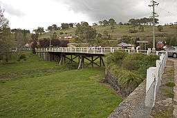 Concrete bridge over the Belubula River in Carcoar | |
| Name origin: Aboriginal: stony river; big lagoon[1] | |
| Country | Australia |
|---|---|
| State | New South Wales |
| Region | IBRA: South Eastern Highlands |
| District | Central West |
| Municipalities | Bathurst, Blayney, Cabonne |
| Part of | Murray–Darling basin |
| Tributaries | |
| - left | Coombing Creek, Mandurama Ponds, Limestone Creek (New South Wales), Jacks Creek (New South Wales) |
| - right | Cadiangullong Creek, Swallow Creek, Panuara Rivulet, Nyrang Creek |
| Landmark | Carcoar Dam |
| Source | |
| - location | south of Vittoria |
| - elevation | 936 m (3,071 ft) |
| Mouth | Lachlan River |
| - location | east of Gooloogong |
| - elevation | 262 m (860 ft) |
| Length | 165 km (103 mi) |
| [2] | |
Belubula River, a perennial river that is part of the Lachlan catchment within the Murray–Darling basin, is located in the central west region of New South Wales, Australia.
Location and features
The river rises south of Vittoria, midway between Bathurst and Orange and generally flows south and west, joined by eight minor tributaries, flowing through Carcoar Lake where its flow is regulated, before reaching its mouth at the Lachlan River, east of Gooloogong; dropping 674 metres (2,211 ft) over its course of 165 kilometres (103 mi).[2]
The name is derived from the Australian Aboriginal meaning for stony river or big lagoon.[1] The original inhabitants of the land alongside the Belubula River are the Australian Aborigines of the Wiradjuri clan.[3]
Towns on the Belubula River, from its source towards its mouth, include Blayney, Carcoar, and Canowindra.
The New South Wales government has begun the second stage of investigations into a potential new dam of up to 700 gigalitres at Cranky Rock on the Belubula River.[4][5]
Gallery
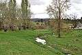 Belubula River, in Carcoar
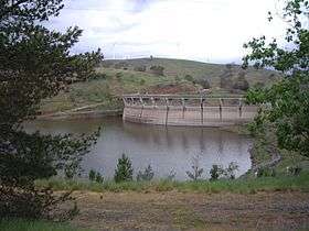 Carcoar Dam, on the Belubula River
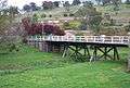 Wooden bridge over the Belubula River, in Carcoar
See also
References
- 1 2 3 "Belubula River". Geographical Names Register (GNR) of NSW. Geographical Names Board of New South Wales. Retrieved 13 January 2013.
- 1 2 "Map of Belubula River". Bonzle.com. Retrieved 13 January 2013.
- ↑ "Cultural heritage". Lachlan Catchment Management Authority. Government of New South Wales. 2013. Retrieved 13 January 2013.
- ↑ "EOI's welcomed for second stage of investigations into potential new dam". WaterNSW. 9 Feb 2016. Retrieved 31 Mar 2017.
- ↑ "Cranky Rock preferred site for Central West Dam". WaterNSW. 9 February 2015. Retrieved 31 Mar 2017.
External links
![]()
- "Lachlan River catchment" (map). Office of Environment and Heritage. Government of New South Wales.
Rivers of the Murrumbidgee River catchment, New South Wales and the Australian Capital Territory, Australia | |||||
|---|---|---|---|---|---|
| |||||
| |||||