Narran River
| Narran River | |
| Watercourse[1] | |
 | |
| Country | Australia |
|---|---|
| States | Queensland, New South Wales |
| Region | IBRA: Brigalow Belt South |
| Districts | Southern Downs, Orana |
| Municipalities | Balonne, Walgett, Brewarrina |
| Part of | Barwon River, Murray–Darling basin |
| Source | A branch of the Balonne River |
| - location | near Dirranbandi, Queensland |
| - elevation | 179 m (587 ft) |
| Mouth | Narran Lake |
| - location | near Brewarrina, New South Wales |
| - elevation | 118 m (387 ft) |
| Length | 299 km (186 mi) |
| Reservoir | Narran Lake |
| [2] | |
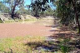
Narran River, a watercourse of the Barwon catchment within the Murray–Darling basin, is located in the Southern Downs district of Queensland and Orana district of New South Wales, Australia.
The river rises south west of Dirranbandi, as a branch of the Balonne River in Queensland, and flows generally to the south and south-west, before reaching its mouth at Narran Lake, between Brewarrina and Walgett in New South Wales; descending 61 metres (200 ft) over its 299 kilometres (186 mi) course.[2]
In March 2010 the Narran River flooded the Angledool Lake at Angledool and then spilled into Weetalabah Creek, crossing the Castlereagh Highway, filling Coocoran Lake near Lightning Ridge.[3]
See also
References
- ↑ "Narran River". Geographical Names Register (GNR) of NSW. Geographical Names Board of New South Wales. Retrieved 10 February 2013.
- 1 2 "Map of Narran River". Bonzle.com. Retrieved 10 February 2013.
- ↑ "Flooding of the Coocoran Lake". Archived from the original on 1 January 2011. Retrieved 5 May 2010.
Rivers of Queensland | |||||||||||||||
|---|---|---|---|---|---|---|---|---|---|---|---|---|---|---|---|
| |||||||||||||||
| |||||||||||||||
| |||||||||||||||
| |||||||||||||||
| |||||||||||||||
| |||||||||||||||
Coordinates: 28°59′57″S 147°48′12″E / 28.99917°S 147.80333°E