Cavan, New South Wales
| Cavan New South Wales | |||||||||||||||
|---|---|---|---|---|---|---|---|---|---|---|---|---|---|---|---|
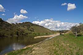 Wee Jasper Road road in Cavan | |||||||||||||||
|
Cavan | |||||||||||||||
| Coordinates | 35°01′S 148°50′E / 35.017°S 148.833°ECoordinates: 35°01′S 148°50′E / 35.017°S 148.833°E | ||||||||||||||
| Population | 47 (2016 census)[1] | ||||||||||||||
| Postcode(s) | 2582 | ||||||||||||||
| Location |
| ||||||||||||||
| LGA(s) | Yass Valley Shire | ||||||||||||||
| County | Cowley | ||||||||||||||
| State electorate(s) | Goulburn | ||||||||||||||
| Federal Division(s) | Eden-Monaro | ||||||||||||||
| |||||||||||||||
Cavan is a rural community situated on the south bank of the Murrumbidgee River in the Yass Valley Shire.[2][3] At the 2016 census, it had a population of 47.[1] It is situated by road, about 40 kilometres southwest of Yass and 43 northwest of Canberra. It was named after the town of Cavan in Ireland.
Cavan Post Office opened on 1 March 1887, closed in 1902, reopened in 1913 and closed in 1951.[4]
References
- 1 2 Australian Bureau of Statistics (27 June 2017). "Cavan (NSW)". 2016 Census QuickStats. Retrieved 22 July 2017.

- ↑ "Cavan". Geographical Names Board of New South Wales. New South Wales Government. Retrieved 22 July 2017.
- ↑ "Cavan". OpenStreetMap. Retrieved 20 December 2017.
- ↑ Premier Postal History, Post Office List, retrieved 2009-06-11
| Wikimedia Commons has media related to Cavan, New South Wales. |
| Towns and residential areas | |
|---|---|
| Localities |
|
Main Article: Local government areas of New South Wales | |
This article is issued from
Wikipedia.
The text is licensed under Creative Commons - Attribution - Sharealike.
Additional terms may apply for the media files.