Mundarlo, New South Wales
| Mundarlo New South Wales | |
|---|---|
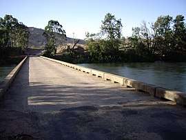 Mundarlo - Murrumbidgee River crossing | |
|
Mundarlo | |
| Coordinates | 35°04′40″S 147°50′39″E / 35.07778°S 147.84417°ECoordinates: 35°04′40″S 147°50′39″E / 35.07778°S 147.84417°E |
| Population | 218 (2006 census)[1] |
| Postcode(s) | 2729 |
| Elevation | 303 m (994 ft) |
| Location |
|
| LGA(s) | Cootamundra Gundagai Regional Council |
| County | Wynyard |
| State electorate(s) | Wagga Wagga |
| Federal Division(s) | Riverina |
Mundarlo is a farming community in the central east part of the Riverina and situated about 13 kilometres south east from Wantabadgery and 18 kilometres north west from Tumblong. At the 2006 census, Mundarlo had a population of 218 people.[1]
Mundarlo is situated on the southern bank of the Murrumbidgee River and there is a low level concrete bridge river crossing at its location.
Mundarloo (as spelt then) Post Office opened on 1 February 1872 but closed the next year.[2]
Notes and references
- 1 2 Australian Bureau of Statistics (25 October 2007). "Mundarlo (State Suburb)". 2006 Census QuickStats. Retrieved 4 November 2009.
- ↑ Premier Postal History, Post Office List, retrieved 2009-06-11
| Wikimedia Commons has media related to Mundarlo, New South Wales. |
This article is issued from
Wikipedia.
The text is licensed under Creative Commons - Attribution - Sharealike.
Additional terms may apply for the media files.