Murrumbidgee Irrigation Area
Coordinates: 34°19′10″S 146°04′02″E / 34.31944°S 146.06722°E
| Irrigation in the Riverina area of New South Wales, Australia | |
|---|---|
| Irrigated area | 660,000 hectares (1,600,000 acres) |
| Water sources for irrigation |
|
| Annual investment in irrigation | A$5 billion |
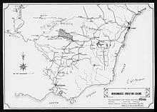
The Murrumbidgee Irrigation Area (MIA) is geographically located within the Riverina area of New South Wales. It was created to control and divert the flow of local river and creek systems for the purpose of food production. The main river systems feeding and fed by the area are the Murrumbidgee and the Tumut. It is one of the most diverse and productive regions in Australia contributing over A$5 billion annually to the Australian economy.[1] The MIA was first established in 1912 after the commissioning of Burrinjuck Dam. Further expansion occurred in the 1970s with the completion of the Snowy Mountains Scheme and construction of Blowering Dam on the Tumut River, which meets the Murrumbidgee near Gundagai.
The system is still regarded as a major engineering achievement comprising an elaborate series of weirs, canals and holding ponds (fed by upstream rivers and dams).
Many of the towns within the area which include Leeton and Griffith were purpose built and designed for the project and remain as thriving communities today. The two towns are growing at a rapid rate due to sustainable employment. The growth of inland centres is unusual for central New South Wales which displays the uniqueness of the MIA.
The layout of the towns of Giffith and Leeton were designed in 1914 by Walter Burley Griffin, an american architect and town planner who had just won the competition for the plan for Canberra in 1912.
The irrigation area has become increasingly controversial in the early twenty-first century, after consecutive years of drought and a growing Australian population have led to demands for greater levels of water conservation.
See also
References
- ↑ "Murrumbidgee Irrigation Limited Productivity Commission Submission" (PDF). Archived from the original (PDF) on 3 June 2011.
External links
![]()
- Murrumbidgee Irrigation Limited corporate website