Borambola, New South Wales
| Borambola New South Wales | |
|---|---|
 Borambola | |
|
Borambola | |
| Coordinates | 35°12′S 147°40′E / 35.200°S 147.667°ECoordinates: 35°12′S 147°40′E / 35.200°S 147.667°E |
| Population | 129 (2006 census)[1] |
| Postcode(s) | 2650 |
| Elevation | 292 m (958 ft) |
| Location |
|
| County | Wynyard |
| State electorate(s) | Wagga Wagga |
Borambola is a rural community in the central east part of the Riverina. It is situated on the Sturt Highway about 16 kilometres east of Alfredtown and 30 kilometres east from Wagga Wagga. At the 2006 census, Borambola had a population of 129 people.[1]
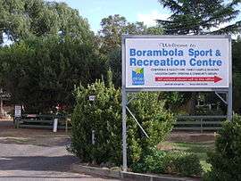
The Borambola area is home to the Borambola Sport and Recreation Centre that caters for conference and facility hire, as well as family, vacation, school camps and reunion camps.[3] Borambola Sport and Recreation Centre is managed by NSW Sport and Recreation.
Notes and references
- 1 2 Australian Bureau of Statistics (25 October 2007). "Borambola (State Suburb)". 2006 Census QuickStats. Retrieved 20 June 2009.
- ↑ Travelmate Archived March 25, 2007, at the Wayback Machine.
- ↑ Borambola Sport and Recreation Centre web page
| Wikimedia Commons has media related to Borambola, New South Wales. |
This article is issued from
Wikipedia.
The text is licensed under Creative Commons - Attribution - Sharealike.
Additional terms may apply for the media files.