Whitton, New South Wales
| Whitton New South Wales | |
|---|---|
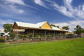 Train station, now disused and relocated to the town museum | |
|
Whitton | |
| Coordinates | 34°30′54″S 146°11′06″E / 34.51500°S 146.18500°ECoordinates: 34°30′54″S 146°11′06″E / 34.51500°S 146.18500°E |
| Population | 496 (2016 census)[1] |
| Postcode(s) | 2705 |
| Elevation | 147 m (482 ft) |
| Location | |
| LGA(s) | Leeton Shire |
| County | Cooper |
| State electorate(s) | Murray |
| Federal Division(s) | Farrer |
Whitton is a small town located in Leeton Shire in the Australian state of New South Wales. Founded in 1850, it is named after John Whitton (1820–98), Engineer-in-Charge of the New South Wales Government Railways. The railway reached Whitton in 1881. At the 2016 census, Whitton had a population of 496.[1]
Hulong Post Office opened on 15 October 1881 and was renamed Whitton in 1883.[2]
Whitton contains the Ricebowl Hotel, 2 general stores, a post office, St Carthage Catholic Church, St John's Anglican Church, a fire station, a bowling club, and a number of houses.
References
- 1 2 Australian Bureau of Statistics (27 June 2017). "Whitton (State Suburb)". 2016 Census QuickStats. Retrieved 27 June 2017.

- ↑ Premier Postal History, Post Office List, retrieved 2009-06-11
.jpg)
Whitton Railway Station (1899-1925)
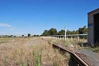
Whitton Railway Station

Whitton Railway Station
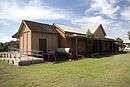
Whitton Railway Station
| Preceding station | NSW Branch lines | Following station | ||
|---|---|---|---|---|
towards Hay | Hay Line (closed section) | towards Junee |
| Wikimedia Commons has media related to Whitton, New South Wales. |
This article is issued from
Wikipedia.
The text is licensed under Creative Commons - Attribution - Sharealike.
Additional terms may apply for the media files.