Illilawa, New South Wales
| Illilawa New South Wales | |
|---|---|
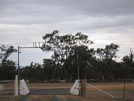 Illilawa station entrance | |
|
Illilawa Location in New South Wales | |
| Coordinates | 34°26′32″S 144°59′32″E / 34.44222°S 144.99222°ECoordinates: 34°26′32″S 144°59′32″E / 34.44222°S 144.99222°E |
| Postcode(s) | 2711 |
| Elevation | 86 m (282 ft) |
| Location | |
| LGA(s) | Hay Shire |
| County | Waradgery |
| State electorate(s) | Murray |
| Federal Division(s) | Farrer |
Illilawa is a locality in the central part of the Riverina, in New South Wales, Australia. It is about 18 kilometres north east from Hay and 48 kilometres south west from Gunbar by road.
Other than private residences and buildings in the area of the small rural population, Illilawa is the site of a disused railway station.
References
| Wikimedia Commons has media related to Illilawa, New South Wales. |
This article is issued from
Wikipedia.
The text is licensed under Creative Commons - Attribution - Sharealike.
Additional terms may apply for the media files.