Rosewood, New South Wales
| Rosewood New South Wales | |
|---|---|
 Entering Rosewood | |
|
Rosewood | |
| Coordinates | 35°40′29″S 147°51′50″E / 35.67472°S 147.86389°ECoordinates: 35°40′29″S 147°51′50″E / 35.67472°S 147.86389°E |
| Population | 214 (2016 census)[1] |
| Postcode(s) | 2652 |
| Elevation | 435 m (1,427 ft) |
| Location |
|
| LGA(s) | Snowy Valleys Council |
| County | Selwyn |
| State electorate(s) | Albury |
| Federal Division(s) | Eden-Monaro |
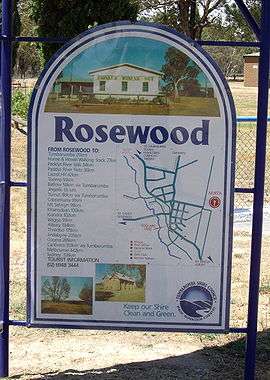
Rosewood is a village community in the south east part of the Riverina. It is situated about 16 kilometres (9.9 mi) south east from Carabost and 19 kilometres (12 mi) north west from Tumbarumba. At the 2016 census, Rosewood had a population of 214.[1] The village is administered at the local government level by the Snowy Valleys Council.
Rosewood Post Office opened on 1 August 1885.[2]
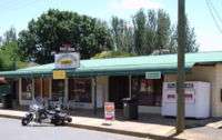
Rosewood General Store and Post Office
Heritage listings
Rosewood has a number of heritage-listed sites, including:
References
- 1 2 Australian Bureau of Statistics (27 June 2017). "Rosewood (Snowy Valleys - NSW) (State Suburb)". 2016 Census QuickStats. Retrieved 29 June 2017.

- ↑ Premier Postal History, Post Office List, retrieved 2009-06-11
- ↑ "Coppabella Blacksmith Shop, Stables and Burial Plot, New South Wales State Heritage Register (NSW SHR) Number H00620". New South Wales State Heritage Register. Office of Environment and Heritage. Retrieved 18 May 2018.
External links
![]()
This article is issued from
Wikipedia.
The text is licensed under Creative Commons - Attribution - Sharealike.
Additional terms may apply for the media files.