Westlock County
Westlock County is a municipal district in central Alberta north of Edmonton. The county was formerly known as the Municipal District of Westlock No. 92, and was created in 1943 from the merger of five smaller municipal districts.
Westlock | |
|---|---|
Municipal district | |
| Westlock County | |
Major communities | |
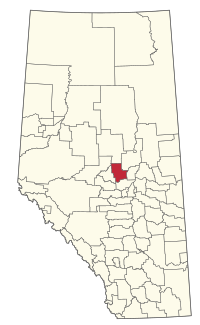 Location within Alberta | |
| Coordinates: 54°09′8″N 113°51′4″W | |
| Country | Canada |
| Province | Alberta |
| Region | Central Alberta |
| Planning region | North Saskatchewan |
| Established | 1943 |
| Incorporated | 1998 |
| Government | |
| • Reeve | Don Savage (acting) |
| • Governing body | Westlock County Council |
| • Office location | Westlock |
| Area (2016)[2] | |
| • Land | 3,171.83 km2 (1,224.65 sq mi) |
| Population (2016)[2] | |
| • Total | 7,220 |
| • Density | 2.3/km2 (6/sq mi) |
| Time zone | UTC−7 (MST) |
| • Summer (DST) | UTC−6 (MDT) |
| Website | westlockcounty.com |
The county lies on the boundary of two of Canada's largest watershed basins. To the north is the Athabasca River, which drains into the Arctic Ocean via the Mackenzie River. To the south is the Sturgeon River which drains via the North Saskatchewan into Hudson Bay.
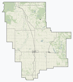
Communities and localities
|
The following urban municipalities are surrounded by Westlock County:[3]
The following hamlets are located within Westlock County:[3]
|
The following localities are located within Westlock County:[4]
|
Demographics
In the 2016 Census of Population conducted by Statistics Canada, Westlock County recorded a population of 7,220 living in 2,670 of its 3,009 total private dwellings, a -5.5% change from its 2011 population of 7,644. With a land area of 3,171.83 km2 (1,224.65 sq mi), it had a population density of 2.3/km2 (5.9/sq mi) in 2016.[2]
In the 2011 Census, Westlock County had a population of 7,644 living in 2,696 of its 2,925 total dwellings, a 10.6% change from its 2006 population of 6,910. With a land area of 3,170.71 km2 (1,224.22 sq mi), it had a population density of 2.4/km2 (6.2/sq mi) in 2011.[5]
Government
The municipal government consists of a reeve and six other elected councillors who work with a permanent staff of 32.
Education
The county is within the Pembina Hills Public Schools, which formed in 1995 as a merger of three school districts.[6]
References
- "Municipal Officials Search". Alberta Municipal Affairs. September 22, 2017. Retrieved September 25, 2017.
- "Population and dwelling counts, for Canada, provinces and territories, and census subdivisions (municipalities), 2016 and 2011 censuses – 100% data (Alberta)". Statistics Canada. February 8, 2017. Retrieved February 8, 2017.
- "Specialized and Rural Municipalities and Their Communities" (PDF). Alberta Municipal Affairs. 2012-03-01. Retrieved 2012-08-12.
- "Standard Geographical Classification (SGC) 2006, Economic Regions: 4813028 - Westlock County, geographical codes and localities, 2006". Statistics Canada. 2010-03-05. Retrieved 2012-08-12.
- "Population and dwelling counts, for Canada, provinces and territories, and census subdivisions (municipalities), 2011 and 2006 censuses (Alberta)". Statistics Canada. February 8, 2012. Retrieved February 8, 2012.
- "Our Division". Pembina Hills Public Schools. Retrieved 2019-08-25.
5310 - 49th Street Barrhead, Alberta T7N 1P3
External links
Places adjacent to Westlock County | |
|---|---|
| Subdivisions | |
|---|---|
| Communities | |
| Cities and urban service areas | |
| Rural municipalities | |
| Specialized municipalities | |
| |