Edmonton Metropolitan Region
The Edmonton Metropolitan Region (EMR), also commonly referred to as the Alberta Capital Region, Greater Edmonton or Metro Edmonton, is a conglomeration of municipalities centred on Alberta's provincial capital of Edmonton.
Edmonton Metropolitan Region Alberta Capital Region Greater Edmonton Metro Edmonton | |
|---|---|
 Downtown Edmonton skyline | |
 Member municipalities of the Edmonton Metropolitan Region Board | |
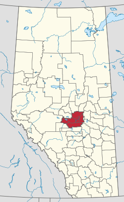 Location of the region in Alberta | |
| Coordinates: 53°34′N 113°31′W | |
| Province | Alberta |
| Country | Canada |
| Area (2016)[1] | |
| • CMA | 9,438.86 km2 (3,644.36 sq mi) |
| Population (2016)[1] | |
| • CMA | 1,321,426 |
| • CMA density | 140.0/km2 (363/sq mi) |
| Time zone | UTC-7 (MST) |
| • Summer (DST) | UTC-6 (MDT) |
| Forward sortation areas | T4X to T6Z, T7X to T8R, T8T, T9E to T9G |
| Area code(s) | 780, 587, 825 |
| Highways | 2, 2A, 14, 15, 16, 16A, 19, 21, 28, 28A, 37, 39, 43, 44, 60, 100, 216 |
| Website | emrb.ca |
The EMR's commonly known boundaries are coincident with those of the Edmonton census metropolitan area (CMA) as delineated by Statistics Canada. However, its boundaries are defined differently for Edmonton Metropolitan Region Board administrative purposes.[2]
The EMR is considered a major gateway to northern Alberta and the Canadian North, particularly for many companies, including airlines and oil/natural gas exploration. Located within central Alberta and at the northern end of the Calgary–Edmonton Corridor, the EMR is the northernmost metropolitan area in Canada.
Edmonton CMA
The Edmonton CMA includes the following 35 census subdivisions (municipalities or municipality equivalents):[3]
- six cities (Beaumont, Edmonton, Fort Saskatchewan, Leduc, St. Albert, and Spruce Grove);
- one specialized municipality (Strathcona County, which includes the Sherwood Park urban service area);
- three municipal districts (Leduc County, Parkland County, and Sturgeon County);
- ten towns (Bon Accord, Bruderheim, Calmar, Devon, Gibbons, Legal, Morinville, Redwater, Thorsby, and Stony Plain);
- three villages (Spring Lake, Wabamun, and Warburg);
- eight summer villages (Betula Beach, Golden Days, Itaska Beach, Kapasiwin, Lakeview, Point Alison, Seba Beach, and Sundance Beach); and
- four Indian reserves for three First Nations (Alexander 134 of the Alexander First Nation, Enoch Cree Nation 135 of the Enoch Cree Nation, and Wabamun 133A and 133B of the Paul First Nation).
The Edmonton CMA is the largest CMA in Canada by area at 9,426.73 km2 (3,639.68 sq mi).[4] In the 2016 Census, it had a population of 1,321,426, making it the sixth largest CMA in Canada by population.[5] The Edmonton CMA comprises the majority of Statistics Canada's Division No. 11 in Alberta.
Demographics
In the 2016 Census of Population conducted by Statistics Canada, the Edmonton metropolitan region recorded a population of 1,321,426 living in 502,143 of its 537,634 total private dwellings, a change of 13.9% from its 2011 population of 1,159,869. With a land area of 9,438.86 km2 (3,644.36 sq mi), it had a population density of 140.0/km2 (362.6/sq mi) in 2016.[1]
Ethnicity
| Ethnic groups in Edmonton's metropolitan region (2016)[1] | Population | % of total population | |
|---|---|---|---|
| Ethnic group | European | 814,405 | 61.6% |
| South Asian | 91,420 | 6.9% | |
| Chinese | 60,200 | 4.6% | |
| Black | 57,820 | 4.4% | |
| Filipino | 61,040 | 4.6% | |
| Aboriginal | 89,865 | 6.8% | |
| Latin American | 18,755 | 1.4% | |
| Arab | 25,505 | 1.9% | |
| Southeast Asian | 17,270 | 1.3% | |
| Korean | 7,585 | 0.6% | |
| West Asian | 6,750 | 0.5% | |
| Japanese | 2,470 | 0.2% | |
| Other visible minority | 4,045 | 0.3% | |
| Mixed visible minority | 11,125 | 0.8% | |
| Total visible minority population | 363,990 | 27.5% | |
| Aboriginal group | First Nations | 54,695 | 4.1% |
| Métis | 38,155 | 2.9% | |
| Inuit | 1,615 | 0.1% | |
| Total Aboriginal population | 89,865 | 6.8% | |
| Total population | 1,321,426 | 100% | |
Edmonton Metropolitan Region Board
A fragmentation in regional cooperation and partnership has long played a divisive role within the EMR. Particularly, Edmonton was frustrated that its surrounding municipalities were receiving an increased tax base for major industrial development, while not contributing to Edmonton's burden to maintain and build new infrastructure within Edmonton used by the residents and businesses of the surrounding municipalities.
After pulling out of the Alberta Capital Region Alliance (ACRA), Edmonton lobbied the provincial government to establish some form of regional government that would be more effective in fostering regional cooperation between it and its surrounding municipalities. As a result, Premier Ed Stelmach announced in December 2007 that a governing board would be established for Edmonton's Capital Region.[6] Four months later, the Capital Region Board was formed on April 15, 2008 with the passing of the Capital Region Board Regulation by Order in Council 127/2008 under the authority of the Municipal Government Act.[7] On October 26, 2017,[8] the Capital Region Board (CRB) was renamed to the Edmonton Metropolitan Region Board (EMRB).[9]
Member municipalities
The CRB was originally established with 25 participating or member municipalities[10] – 23 of which were within the Edmonton CMA and two of which were outside the CMA (Lamont County and the Town of Lamont).[2] The number of member municipalities was reduced to 24 on September 10, 2010[11] after the Village of New Sarepta dissolved to hamlet status under the jurisdiction of Leduc County on September 1, 2010.[12] Concurrent with the CRB's name change to the EMRB in October 2017, municipal membership decreased from 24 to 13 to include only those municipalities with a population of 5,000 or more.[13]
More specifically, the EMRB includes:[13]
- six cities (Beaumont, Edmonton, Fort Saskatchewan, Leduc, St. Albert, and Spruce Grove);
- one specialized municipality (Strathcona County, which includes the Sherwood Park urban service area);
- three municipal districts (Leduc County, Parkland County, and Sturgeon County); and
- three towns (Devon, Morinville, and Stony Plain).
Edmonton Metropolitan Region Growth Plan
Under the CRB Regulation, the CRB was tasked with preparing a growth plan to cover land use, intermunicipal transit, housing, and geographic information services components.[14] In March, 2010, Growing Forward: The Capital Region Growth Plan (CRGP), consisting of individual plans for these four components and two addenda, was approved by the Government of Alberta.[15]
The CRGP includes a population and employment forecast for the Capital Region. With a base population of 1.12 million in 2009, the CRB has forecasted the population of the Capital Region to reach 1.31 million by 2019.[16] However, the 2019 population estimate was reached and exceeded by 2014.[17] The CRGP also designates priority growth areas and cluster country residential areas within the Capital Region.[18]
List of municipalities
The following is a list of municipalities in the Edmonton CMA, with those that are members of the EMRB indicated accordingly.
| Municipality | Municipal status[19] |
Federal census population (2016)[20] |
Latest municipal census population (2016-2017)[21] |
Latest municipal census year[21] |
EMRB member[13] |
|---|---|---|---|---|---|
| Alexander 134 | Indian reserve | 1,099 | N | ||
| Beaumont | City | 17,396 | 18,320 | 2017[22] | Y |
| Betula Beach | Summer village | 16 | N | ||
| Bon Accord | Town | 1,529 | N | ||
| Bruderheim | Town | 1,308 | N | ||
| Calmar | Town | 2,228 | N | ||
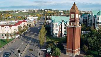
| Devon | Town | 6,578 | Y | ||
| Edmonton | City | 932,546 | 899,447 | 2016 | Y |
| Enoch Cree Nation 135 | Indian reserve | 1,690 | N | ||
| Fort Saskatchewan | City | 24,149 | 25,533 | 2017[23] | Y |
| Gibbons | Town | 3,159 | N | ||
| Golden Days | Summer village | 160 | N | ||
| Itaska Beach | Summer village | 23 | N | ||
| Kapasiwin | Summer village | 10 | N | ||
| Lakeview | Summer village | 30 | N | ||
| Leduc | City | 29,993 | 31,130 | 2017[24] | Y |
| Leduc County | Municipal district | 13,780 | Y | ||
| Legal | Town | 1,345 | N | ||
| Morinville | Town | 9,848 | 9,893 | 2016 | Y |
| Parkland County | Municipal district | 32,097 | Y | ||
| Point Alison | Summer village | 10 | N | ||
| Redwater | Town | 2,053 | N | ||
| Seba Beach | Summer village | 169 | N | ||
| Spring Lake | Village | 699 | N | ||
| Spruce Grove | City | 34,066 | 34,881 | 2017[25] | Y |
| St. Albert | City | 65,589 | 64,645 | 2016 | Y |
| Stony Plain | Town | 17,189 | Y | ||
| Strathcona County | Specialized municipality | 98,044 | Y | ||
| Sturgeon County | Municipal district | 20,495 | Y | ||
| Sundance Beach | Summer village | 73 | N | ||
| Thorsby | Town | 985 | N | ||
| Wabamun | Village | 682 | N | ||
| Wabamun 133A and 133B | Indian reserve | 1,622 | N | ||
| Warburg | Village | 766 | N | ||
| Total Edmonton CMA | 1,321,426 | — | — | — | |
Major industrial areas
Major industrial areas within the ECR include the northwest, southeast and Clover Bar industrial areas in Edmonton, Nisku Industrial Business Park in Leduc County, Acheson Industrial Area in Parkland County, Refinery Row in Strathcona County, and Alberta's Industrial Heartland spanning portions of Sturgeon County, Strathcona County, Lamont County and Fort Saskatchewan.
At the moment, two more major industrial areas are in the final stages of establishment. The establishment of the Horse Hills industrial area in northeast Edmonton is in the final planning stages, while Edmonton Airports is currently planning its inland port development under the Port Alberta initiative at the Edmonton International Airport within Leduc County.
See also
- Edmonton
- Calgary-Edmonton Corridor
- Calgary Metropolitan Region
References
- Statistics Canada (February 8, 2017). "Census Profile, 2016 Census - Edmonton [Census metropolitan area], Alberta and Alberta [Province]". www12.statcan.gc.ca. Statistics Canada - Government of Canada. Archived from the original on February 14, 2020. Retrieved February 14, 2020.
- "Fact Sheet: Geographic Profile" (PDF). Capital Region Board. Archived from the original (PDF) on 2013-03-25. Retrieved 2012-02-13.
- "Census Profile – Geographic hierarchy: Edmonton (Census metropolitan area)". Statistics Canada. 2012-02-08. Archived from the original on August 3, 2016. Retrieved May 28, 2016.
- "Population and dwelling counts, for census metropolitan areas, 2011 and 2006 censuses". Statistics Canada. 2012-02-08. Archived from the original on 2012-06-22. Retrieved 2012-02-13.
- Canada, Government of Canada, Statistics. "Census Profile, 2016 Census - Edmonton [Census metropolitan area], Alberta and Canada [Country]". www12.statcan.gc.ca. Archived from the original on 2018-09-01. Retrieved 2018-08-30.
- Archie McLean & Susan Ruttan (2007-12-19). "Mayor "elated" by new regional planning board". Edmonton Journal. Archived from the original on 2012-11-03. Retrieved 2008-01-09.
- "Order in Council 127/2008". Alberta Queen's Printer. April 15, 2008. Archived from the original on July 16, 2011. Retrieved December 24, 2009.
- "Order in Council 355/2017". Alberta Queen's Printer. October 26, 2017. Archived from the original on December 1, 2017. Retrieved November 18, 2017.
- Simons, Paula (November 1, 2017). "Welcome, neighbours, to the Edmonton Metropolitan Region". Edmonton Journal. Archived from the original on November 7, 2017. Retrieved November 13, 2017.
- "Order in Council (O.C.) 66/2010". Province of Alberta. 2010-03-15. Archived from the original on 2012-04-04. Retrieved 2012-02-13.
- "Order in Council (O.C.) 316/2010". Province of Alberta. 2010-03-15. Archived from the original on 2012-04-04. Retrieved 2012-02-13.
- "Order in Council (O.C.) 230/2010". Alberta Queen's Printer. Archived from the original on 2011-07-16. Retrieved 2010-07-15.
- "New faces for a newly revitalized region". Edmonton Metropolitan Region Board. October 28, 2017. Archived from the original on November 14, 2017. Retrieved November 13, 2017.
- "Capital Region Board". Capital Region Board. Archived from the original on 2012-01-03. Retrieved 2012-01-21.
- "Capital Region Growth Plan: Growing Forward". Capital Region Board. Archived from the original on 2015-03-25. Retrieved 2012-01-21.
- "The Capital Region Growth Plan Addendum" (PDF). Capital Region Board. December 2009. Archived from the original (PDF) on 2013-03-25. Retrieved 2012-01-21.
- "Population of census metropolitan areas". Statcan.gc.ca. 2017-03-08. Archived from the original on 2016-12-16. Retrieved 2017-04-30.
- "The Capital Region Growth Plan Addendum" (PDF). Capital Region Board. October 2009. Archived from the original (PDF) on 2013-03-25. Retrieved 2012-01-21.
- "2010 Municipal Codes" (PDF). Alberta Municipal Affairs. 2010-04-01. Archived (PDF) from the original on 2011-01-03. Retrieved 2010-09-03.
- "Focus on Geography Series, 2016 Census - Census metropolitan area of Edmonton". Statistics Canada. April 23, 2017. Archived from the original on December 2, 2017. Retrieved November 18, 2017.
- "2016 Municipal Affairs Population List" (PDF). Alberta Municipal Affairs. ISBN 978-1-4601-3127-5. Archived (PDF) from the original on June 9, 2017. Retrieved November 19, 2017.
- "2017 Municipal Census Population Results". Town of Beaumont. June 27, 2017. p. 161. Archived from the original on December 1, 2017. Retrieved June 29, 2017.
- "Fort Saskatchewan population continues to grow". City of Fort Saskatchewan. June 6, 2017. Retrieved June 6, 2017.
- "City of Leduc population surpasses 31,000 according to 2017 census". City of Leduc. June 28, 2017. Archived from the original on December 1, 2017. Retrieved June 29, 2017.
- "Municipal Census - 2017 Demographic Report". City of Spruce Grove. August 14, 2017. Archived from the original on December 1, 2017. Retrieved November 19, 2017.
- "Census". Strathcona County. August 23, 2015. Archived from the original on August 27, 2017. Retrieved November 18, 2017.
External links
- Official website

- Edmonton.com - Portal to Greater Edmonton
- EEDC - Edmonton Economic Development Corporation
- Government of Alberta Regional Dashboard economic data for the Edmonton CMA
Places adjacent to Edmonton Metropolitan Region | |
|---|---|
| Subdivisions | |
|---|---|
| Communities | |
| Cities and urban service areas | |
| Regions | |
| |