Camrose County
Camrose County is a municipal district in central Alberta, Canada. It is located in Census Division 10, around the City of Camrose.
Camrose County | |
|---|---|
Municipal district | |
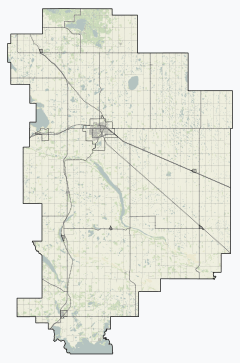 Bawlf Bittern Lake Hay Lakes New Norway Armena Meeting Creek Ohaton Tillicum Beach | |
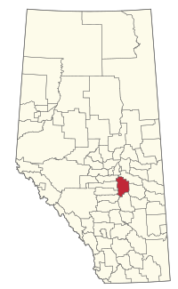 Location within Alberta | |
| Country | Canada |
| Province | Alberta |
| Region | Central Alberta |
| Census division | No. 10 |
| Established | 1944 |
| Incorporated | 1963 |
| Government | |
| • Reeve | Cindy Trautman |
| • Governing body | Camrose County Council
|
| • Administrator | Paul King |
| • Office location | Camrose |
| Area (2016)[2] | |
| • Land | 3,324.21 km2 (1,283.48 sq mi) |
| Population (2016)[2] | |
| • Total | 8,458 |
| • Density | 2.5/km2 (6/sq mi) |
| Time zone | UTC-7 (MST) |
| Website | county.camrose.ab.ca |
Demographics
In the 2016 Census of Population conducted by Statistics Canada, Camrose County recorded a population of 8,458 living in 3,118 of its 3,492 total private dwellings, a 5.7% change from its 2011 population of 8,004. With a land area of 3,324.21 km2 (1,283.48 sq mi), it had a population density of 2.5/km2 (6.6/sq mi) in 2016.[2]
In the 2011 Census, Camrose County had a population of 7,721 living in 2,861 of its 3,173 total dwellings, an 8% change from its 2006 adjusted population of 7,150. With a land area of 3,320.61 km2 (1,282.09 sq mi), it had a population density of 2.3/km2 (6.0/sq mi) in 2011.[3] Following the Village of New Norway's dissolution in 2012, Statistics Canada adjusted Camrose County's 2011 population by an additional 283 people to 8,004.[4]
The population of Camrose County according to its 2008 municipal census is 7,577.[5]
Communities and localities
The following urban municipalities are surrounded by Camrose County:[6][7]
- Bawlf
- Bittern Lake
- Edberg
- Hay Lakes
- Rosalind
- none
The following hamlets are located within Camrose County:[7]
- Armena
- Duhamel
- Ferintosh, dissolved from village status on January 1, 2020[8]
- Kelsey
- Kingman
- Meeting Creek
- New Norway, dissolved from village status on November 1, 2012[9]
- Ohaton
- Pelican Point
- Round Hill
- Tillicum Beach
The following localities are located within Camrose County:[10]
- Localities
- Ankerton
- Barlee Junction
- Battle
- Braim (designated place)
- Campbelton
- Demay
- Dinant
- Dorenlee
- Dried Meat Lake
- Edensville
- Ervick
- Ferlow Junction
- Grouse Meadows
- Kiron
- Mccree Acres
- Meldal Subdivision
- Miquelon Acres
- Paradise Resort
- Sherman Park Subdivision
- Twomey
- Viewpoint
- Woodridge Heights
References
- "Municipal Officials Search". Alberta Municipal Affairs. September 22, 2017. Retrieved September 25, 2017.
- "Population and dwelling counts, for Canada, provinces and territories, and census subdivisions (municipalities), 2016 and 2011 censuses – 100% data (Alberta)". Statistics Canada. February 8, 2017. Retrieved February 8, 2017.
- "Population and dwelling counts, for Canada, provinces and territories, and census subdivisions (municipalities), 2011 and 2006 censuses (Alberta)". Statistics Canada. February 8, 2012. Retrieved February 8, 2012.
- "Interim List of Changes to Municipal Boundaries, Status, and Names From January 2, 2012 to January 1, 2013 (Table 1 – Changes to census subdivisions in alphabetical order by province and territory)" (XLSX). Statistics Canada. August 18, 2012. Retrieved August 17, 2013.
- Alberta Municipal Affairs (September 15, 2009). "Alberta 2009 Official Population List" (PDF). Retrieved September 12, 2010.
- "Camrose, City (Census Subdivision), Alberta". Statistics Canada. 2012-06-20. Retrieved 2012-08-13.
- "Specialized and Rural Municipalities and Their Communities" (PDF). Alberta Municipal Affairs. 2012-03-01. Archived from the original (PDF) on 2012-04-09. Retrieved 2012-08-11.
- "O.C. 190/2019". Government of Alberta. October 8, 2019. Retrieved October 13, 2019.
- "O.C. 328/2012". Province of Alberta. 2012-10-17. Retrieved 2012-11-01.
- "Standard Geographical Classification (SGC) 2006, Economic Regions: 4810001 - Camrose County No. 22, geographical codes and localities, 2006". Statistics Canada. 2010-03-05. Archived from the original on 2013-05-25. Retrieved 2012-08-11.
External links
Places adjacent to Camrose County | |
|---|---|
| Subdivisions | |
|---|---|
| Communities | |
| Cities and urban service areas | |
| Rural municipalities | |
| Specialized municipalities | |
| |