County of Northern Lights
The County of Northern Lights is a municipal district in northwest Alberta, Canada. Located in Census Division 17, its municipal office is located in the Town of Manning.
County of Northern Lights | |
|---|---|
Municipal district | |
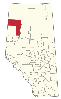 Location within Alberta | |
| Country | |
| Province | |
| Region | Northern Alberta |
| Census division | No. 17 |
| Established | 1995 |
| Incorporated | 1995 |
| Government | |
| • Reeve | Terry Ungarian |
| • Governing body | County of Northern Lights Council |
| • Office location | Manning |
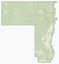
| Area (2016)[2] | |
| • Land | 20,755.37 km2 (8,013.69 sq mi) |
| Population (2016)[2] | |
| • Total | 4,200 |
| • Density | 0.2/km2 (0.5/sq mi) |
| Time zone | UTC-7 (MST) |
| Website | countyofnorthernlights.com |
The municipality recently changed its name from the Municipal District (M.D.) of Northern Lights No. 22 to the County of Northern Lights. The Province of Alberta officially approved the name change on February 3, 2010.[3]
On April 1, 1995, the M.D. of Northern Lights No. 22 was formed through the incorporation of the former Improvement District No. 22 as a municipal district.
Demographics
As a census subdivision in the 2016 Census of Population conducted by Statistics Canada, Northern Lights recorded a population of 4,200 living in 1,538 of its 1,846 total private dwellings, a 2% change from its 2011 population of 4,117.[2] This includes the population of the Paddle Prairie Metis Settlement (544),[4] located within the census subdivision that is a municipality independent of the County of Northern Lights.[5] With a land area of 20,755.37 km2 (8,013.69 sq mi), the census subdivision had a population density of 0.2/km2 (0.5/sq mi) in 2016.[2] Excluding the Paddle Prairie Metis Settlement, the County of Northern Lights had a population of 3,656 in 2016,[2] a change of 2.8% from its 2011 population of 3,555.[6]
As a census subdivision in the 2011 Census of Population, Northern Lights had a population of 4,117 living in 1,527 of its 1,655 total dwellings, a 9.1% change from its 2006 population of 3,772. This includes the population of the Paddle Prairie Metis Settlement (562)[7] located within the census subdivision that is a municipality independent of the County of Northern Lights.[5] With a land area of 20,744.41 km2 (8,009.46 sq mi), the census subdivision had a population density of 0.2/km2 (0.5/sq mi) in 2011.[8] As a municipality in the 2011 Census, the County of Northern Lights had a population of 3,555 without the Paddle Prairie Métis settlement.[6]
Communities and localities
|
The following urban municipalities are surrounded by the County of Northern Lights:[5]
The following hamlets are located within the County of Northern Lights:[5]
|
The following localities are located within the County of Northern Lights:[9]
|
Attractions
- Figure Eight Lake Provincial Recreation Area
- Leddy Lake Provincial Recreation Area
- Sulphur Lake Provincial Recreation Area
- Notikewin Provincial Park
References
- "Municipal Officials Search". Alberta Municipal Affairs. September 22, 2017. Retrieved September 25, 2017.
- "Population and dwelling counts, for Canada, provinces and territories, and census subdivisions (municipalities), 2016 and 2011 censuses – 100% data (Alberta)". Statistics Canada. February 8, 2017. Retrieved February 8, 2017.
- Province of Alberta (2010-02-03). "Order in Council 24/2010". Retrieved 2010-02-03.
- "Population and dwelling counts, for Canada, provinces and territories, and designated places, 2016 and 2011 censuses – 100% data (Alberta)". Statistics Canada. February 8, 2017. Retrieved February 9, 2017.
- "Specialized and Rural Municipalities and Their Communities" (PDF). Alberta Municipal Affairs. December 28, 2012. Retrieved January 6, 2013.
- "2012 Municipal Affairs Population List" (PDF). Alberta Municipal Affairs. November 22, 2012. Retrieved January 6, 2013.
- "Population and dwelling counts, for Canada, provinces and territories, and designated places, 2011 and 2006 censuses (Alberta)". Statistics Canada. April 11, 2012. Retrieved January 6, 2013.
- "Population and dwelling counts, for Canada, provinces and territories, and census subdivisions (municipalities), 2011 and 2006 censuses (Alberta)". Statistics Canada. 2012-02-08. Retrieved 2012-02-08.
- "Standard Geographical Classification (SGC) 2006, Economic Regions: 4817076 - Northern Lights No. 22, geographical codes and localities, 2006". Statistics Canada. 2010-03-05. Archived from the original on 2013-05-25. Retrieved 2012-08-11.
External links
Places adjacent to County of Northern Lights | |
|---|---|
| Subdivisions | |
|---|---|
| Communities | |
| Cities and urban service areas | |
| Rural municipalities | |
| Specialized municipalities | |
| |