Lac Ste. Anne County
Lac Ste. Anne County is a municipal district in central Alberta, Canada.
Lac Ste. Anne County | |
|---|---|
Municipal district | |
Major communities | |
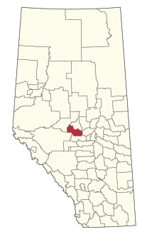 Location within Alberta | |
| Country | Canada |
| Province | Alberta |
| Region | Central Alberta |
| Planning region | Upper Athabasca |
| Established | 1944 |
| Incorporated | 1965 |
| Government | |
| • Reeve | Joe Blakeman |
| • Governing body | Lac Ste. Anne County Council[2]
|
| • Manager | Mike Primeau |
| • Office location | Sangudo |
| Area (2016)[3] | |
| • Land | 2,850.38 km2 (1,100.54 sq mi) |
| Population (2016)[3] | |
| • Total | 10,899 |
| • Density | 3.8/km2 (10/sq mi) |
| Time zone | UTC−07:00 (MST) |
| • Summer (DST) | UTC−06:00 (MDT) |
| Website | lsac.ca |

It is located in Census Division 13, north west of Edmonton. Highway 43 stretches across this county. Its municipal office is located in the Hamlet of Sangudo.
The county was named after Lac Ste. Anne, which in turn was named for Saint Anne.
Demographics
In the 2016 Census of Population conducted by Statistics Canada, Lac Ste. Anne County recorded a population of 10,899 living in 4,346 of its 5,385 total private dwellings, a 6.2% change from its 2011 population of 10,260. With a land area of 2,850.38 km2 (1,100.54 sq mi), it had a population density of 3.8/km2 (9.9/sq mi) in 2016.[3]
In the 2011 Census, Lac Ste. Anne County had a population of 10,260 living in 4,092 of its 4,959 total dwellings, a 3.8% change from its 2006 adjusted population of 9,880. With a land area of 2,845.61 km2 (1,098.70 sq mi), it had a population density of 3.6/km2 (9.3/sq mi) in 2011.[4]
The population of Lac Ste. Anne County according to its 2008 municipal census is 10,220.[5]
Attractions
The municipality of Lac Ste. Anne maintains the Lessard Lake Campground, the Lessard Lake Outdoor Ed Centre, the Riverside Campground, and the Paddle River Dam Campground.
Many summer villages are established, especially on lake shores (such as Lac Ste. Anne, Lac la Nonne, Nakamun Lake, and Lake Isle).
Protected and recreational areas in the county include Lily Lake Provincial Natural Area, Pembina River Provincial Natural Area, Majeau Lake Provincial Natural Area (with two campgrounds), Paddle River Dam Picnic Site, Park Court Provincial Natural Area, Lily Lake Provincial Natural Area and Prefontaine and Brock Lake Provincial Natural Area.
Communities and localities
The following urban municipalities are surrounded by Lac Ste. Anne County:[6]
The following hamlets are located within Lac Ste. Anne County:[6]
- Hamlets
- Cherhill
- Glenevis
- Green Court
- Gunn
- Rich Valley
- Rochfort Bridge
- Sangudo (location of municipal office)
The following localities are located within Lac Ste. Anne County:[7]
- Ardea Park
- Arndt Acres
- Aspen Hills
- Ballantine
- Balm
- Bay Bridge Park
- Bilby
- Birchwood Estates
- Cheviot Hills
- Cheyenne Estates
- Connor Creek
- Corsair Cove Subdivision
- Cosmo
- Darbyson Estates
- Darwell
- Darwell Rolling Woods
- Fern Valley Trailer Park
- Forest West
- Glenford
- Glenister
- Golden Glen Estates
- Hansen-Mayer
- Heatherdown
- Heldar
- Highland Park Subdivision
- Hillview Estates
- Hoffman Beach
- Home Acres
- Horne Beach
- Jalna
- Johnston Park
- Jones Beach
- Lac la Nonne
- Lac Ste. Anne
- Lac Ste. Anne Settlement
- Lake Isle
- Lake Majeau
- Lakewood Estates
- Laurentian Heights
- Lisburn
- Louden Park
- Manly
- Mayfair Park
- Mission Creek Estates
- Nakamun
- Noyes Crossing
- Noyes Crossing Estates
- Padstow
- Paradise Estates
- Peavine
- Pembridge
- Robinson
- Ronan
- Roydale
- Spruce Lane
- Stanger
- Ste Anne
- Stettin
- Tri Lakes Manor
- Valhalla Acres
- Warawa Estates
- Woodland Bay
References
- "Municipal Officials Search". Alberta Municipal Affairs. September 22, 2017. Retrieved September 25, 2017.
- https://www.lsac.ca/index.php/government/county-council/reeve-councillors.html
- "Population and dwelling counts, for Canada, provinces and territories, and census subdivisions (municipalities), 2016 and 2011 censuses – 100% data (Alberta)". Statistics Canada. February 8, 2017. Retrieved February 8, 2017.
- "Population and dwelling counts, for Canada, provinces and territories, and census subdivisions (municipalities), 2011 and 2006 censuses (Alberta)". Statistics Canada. February 8, 2012. Retrieved February 8, 2012.
- Alberta Municipal Affairs (September 15, 2009). "Alberta 2009 Official Population List" (PDF). Retrieved September 12, 2010.
- "Specialized and Rural Municipalities and Their Communities" (PDF). Alberta Municipal Affairs. 2012-03-01. Archived from the original (PDF) on 2012-04-09. Retrieved 2012-08-11.
- "Standard Geographical Classification (SGC) 2006, Economic Regions: 4813001 - Lac Ste. Anne County, geographical codes and localities, 2006". Statistics Canada. 2010-03-05. Archived from the original on 2015-05-18. Retrieved 2012-08-11.
External links
Places adjacent to Lac Ste. Anne County | |
|---|---|
| Subdivisions | |
|---|---|
| Communities | |
| Cities and urban service areas | |
| Rural municipalities | |
| Specialized municipalities | |
| |
| Towns | |
|---|---|
| Villages | |
| Summer villages |
|
| Hamlets |
|
| Métis settlements | |
| Municipal districts | |
| Specialized municipalities | |
| Improvement districts | |
| Indian reserves | |
| National parks | |
| Provincial parks | |
| Other topics | |