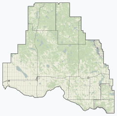
Smoky Lake County
Smoky Lake County is a municipal district in north-eastern Alberta, Canada. Located in Census Division No. 12, its municipal office is located in the Town of Smoky Lake.
Smoky Lake County | |
|---|---|
Municipal district | |
 Location within Alberta | |
| Coordinates: 54°07′15″N 112°28′24″W | |
| Country | Canada |
| Province | Alberta |
| Region | Central Alberta |
| Census division | No. 12 |
| Established | 1943 |
| Incorporated | 1961 (County) |
| Government | |
| • Reeve | Craig Lukinuk |
| • Governing body | Smoky Lake County Council |
| • Office location | Smoky Lake |
| Area (2016)[2] | |
| • Land | 3,412.92 km2 (1,317.74 sq mi) |
| Population (2016)[2] | |
| • Total | 4,107 |
| • Density | 1.2/km2 (3/sq mi) |
| Time zone | UTC−07:00 (MST) |
| • Summer (DST) | UTC−06:00 (MDT) |
| Area code(s) | 780 |
| Website | smokylakecounty.ab.ca |
Demographics
As a census subdivision in the 2016 Census of Population conducted by Statistics Canada, Smoky Lake County recorded a population of 4,107 living in 1,556 of its 2,248 total private dwellings, a 5% change from its 2011 population of 3,910.[2] This includes the population of two Métis settlements, Buffalo Lake (712) and Kikino (934),[3] located within the census subdivision that are municipalities independent of Smoky Lake County.[4] With a land area of 3,412.92 km2 (1,317.74 sq mi), the census subdivision had a population density of 1.2/km2 (3.1/sq mi) in 2016.[2] Excluding the two Métis settlements, Smoky Lake County had a population of 2,461 in 2016,[2] a change of 0.1% from its 2011 population of 2,459.[5]
As a census subdivision in the 2011 Census of Population, Smoky Lake County had a population of 3,910 living in 1,481 of its 1,920 total dwellings, a 16.5% change from its 2006 population of 3,357. This includes the population of two Métis settlements, Buffalo Lake (492) and Kikino (959),[6] located within the census subdivision that are municipalities independent of Smoky Lake County.[4] With a land area of 3,412.81 km2 (1,317.69 sq mi), the census subdivision had a population density of 1.1/km2 (3.0/sq mi) in 2011.[7] As a municipality in the 2011 Census, Smoky Lake County had a population of 2,459 without the two Métis settlements.[5]
Communities and localities
|
The following urban municipalities are surrounded by Smoky Lake County:[4]
The following hamlets are located within Smoky Lake County:[4]
|
The following localities are located within Smoky Lake County:[8]
|
|
See also
References
- "Municipal Officials Search". Alberta Municipal Affairs. September 22, 2017. Retrieved September 25, 2017.
- "Population and dwelling counts, for Canada, provinces and territories, and census subdivisions (municipalities), 2016 and 2011 censuses – 100% data (Alberta)". Statistics Canada. February 8, 2017. Retrieved February 8, 2017.
- "Population and dwelling counts, for Canada, provinces and territories, and designated places, 2016 and 2011 censuses – 100% data (Alberta)". Statistics Canada. February 8, 2017. Retrieved February 9, 2017.
- "Specialized and Rural Municipalities and Their Communities" (PDF). Alberta Municipal Affairs. December 28, 2012. Retrieved January 6, 2013.
- "2012 Municipal Affairs Population List" (PDF). Alberta Municipal Affairs. November 22, 2012. Retrieved January 6, 2013.
- "Population and dwelling counts, for Canada, provinces and territories, and designated places, 2011 and 2006 censuses (Alberta)". Statistics Canada. April 11, 2012. Retrieved January 6, 2013.
- "Population and dwelling counts, for Canada, provinces and territories, and census subdivisions (municipalities), 2011 and 2006 censuses (Alberta)". Statistics Canada. 2012-02-08. Retrieved 2012-02-08.
- "Standard Geographical Classification (SGC) 2006, Economic Regions: 4812022 - Smoky Lake County, geographical codes and localities, 2006". Statistics Canada. 2010-03-05. Retrieved 2012-08-12.
- "Ownership Map" (PDF). Smoky Lake County. July 30, 2013. Retrieved September 1, 2014.
- "Mons View Resort and Mons Lake Estate" (PDF). Smoky Lake County. Retrieved September 1, 2014.
